Hong Kong–Zhuhai–Macau Bridge
| Hong Kong–Zhuhai–Macau Bridge | |
|---|---|
.jpg) | |
| Coordinates | 22°17′N 113°47′E / 22.28°N 113.78°ECoordinates: 22°17′N 113°47′E / 22.28°N 113.78°E |
| Carries | Motor vehicles |
| Crosses |
|
| Locale | Pearl River Delta |
| Website |
hzmb hzmb www |
| Characteristics | |
| Design | Bridge–tunnel system |
| Total length | 39 kilometres (24 mi) |
| No. of lanes | 6 |
| History | |
| Opened | 21 October 2018 |
| Hong Kong–Zhuhai–Macau Bridge | |||||||||||||
 | |||||||||||||
| Chinese name | |||||||||||||
|---|---|---|---|---|---|---|---|---|---|---|---|---|---|
| Traditional Chinese | 港珠澳大橋 | ||||||||||||
| Simplified Chinese | 港珠澳大桥 | ||||||||||||
| Cantonese Yale | Góngjyūou Daaihkìuh | ||||||||||||
| Hanyu Pinyin | Gǎngzhū'ào Dàqiáo | ||||||||||||
| |||||||||||||
| Portuguese name | |||||||||||||
| Portuguese | Ponte Hong Kong–Zhuhai–Macau | ||||||||||||
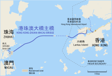
The Hong Kong–Zhuhai–Macau Bridge or Hong Kong–Zhuhai–Macao Bridge (HKZMB or HZMB) is a bridge–tunnel system, which consists of a series of three cable-stayed bridges and one undersea tunnel, as well as 2 artificial islands. It spans the Lingdingyang channel, which connects Hong Kong with Macau and Zhuhai, three major cities on the Pearl River Delta. For the construction cost of the HZMB Main Bridge, the total contribution of the three places (Hong Kong, Mainland and Macau) will be RMB¥15.73 billion, among which the Government of the Hong Kong SAR will contribute RMB¥6.75 billion.[1] It is among the longest fixed-links in the world and is a major landmark in the area.
Originally set to be opened to traffic in October 2016,[2][3][4] the structure was completed on 14 November 2017[5] and was planned to be opened in 21 October 2018 with journalists already given rides over the bridge.[6][1][5]
Planning
Background
Hopewell Holdings founder and then-managing director Gordon Wu proposed the concept of a bridge-tunnel linking China, Hong Kong, and Macau in the 1980s. Wu stated that he got the idea in 1983 from the Chesapeake Bay Bridge–Tunnel. In 1988, Wu pitched the concept to Guangdong and Beijing officials. He envisaged a link farther north than the current design, beginning at Black Point near Tuen Mun, Hong Kong and crossing the Pearl River Estuary via Neilingding Island and Qi'ao Island. Wu's proposed bridge would end at the Chinese village of Tangjia, and a new road would continue south through Zhuhai before terminating at Macau.[7] Discussions stalled after the Tiananmen Square massacre in mid-1989 "unnerved" Wu and other foreign investors and caused Hopewell's Hong Kong share prices to plunge.[8]
The route proposed by Wu was promoted by the government of Zhuhai under the name Lingdingyang Bridge. In the mid-1990s, Zhuhai built a bridge between the mainland and Qi'ao Island that was intended as the first phase of this route, though the full scheme had not been approved by either the Chinese nor Hong Kong governments at that time.[9] China's central government showed support for this project on 30 December 1997.[10] The new Hong Kong government was reticent, stating that it was still awaiting cross-border traffic study results, and Hong Kong media questioned the environmental impact of the project with regard to air pollution, traffic, and marine life.[11]
In November 2002, Zhu Rongji, the then-Premier of China, expressed support for Wu's concept. In 2003, the Chinese government also expressed support for the idea. In July 2003 Donald Tsang, then Chief Secretary for Administration of Hong Kong, went to Beijing to meet with the Chinese government about the bridge. At the third meeting of the China/Hong Kong Conference on the Co-ordination of Major Infrastructure Projects (the Conference) held on 20 September 2002, it was agreed that a joint study should be conducted on the transport linkage between Hong Kong and Pearl River West. In August 2003 the Hong Kong–Zhuhai–Macao Bridge Advance Work Coordination Group was established.
A study was completed by the National Development and Reform Commission and the Hong Kong Government on the transport linkage between Hong Kong and the western bank of the Pearl River Delta. The study stated that a bridge linking Hong Kong, Zhuhai and Macau would provide significant macro socio-economic benefits for the Greater Pearl River Delta Region including Hong Kong. The study has considered three alignments linking the two banks of Pearl River. The result of the study is that the Hong Kong (Lantau)–Zhuhai–Macao Bridge proposed by the HKSAR Government, a link connecting China with the two regions under "one country, two systems", would be given priority.
Preparation
In order to coordinate the project, Hong Kong–Zhuhai–Macao Bridge Advance Work Coordination Group was established in 2003. In the second meeting, officials from three sides decided to set up an office specifically in Guangzhou to do the work of the group and appointed a design institute in China to conduct the feasibility study and produce a report on landing points for the bridge. The landing points were studied and factors such as economic effectiveness and environmental issues determined the final location of those points.
For the part of the bridge that is situated in Hong Kong, the Environment, Transport and Works Bureau sought $59 million from the Legislative Council's public works subcommittee for investigations and preliminary design work.
Preliminary design work on the proposed Y-shaped bridge was completed at the end of 2004.
The seabed feasibility study began in May 2007.
In August 2008, the China's Central Government, the governments of Guangdong, Hong Kong and Macau agreed to finance 42% of the total costs. The remaining 58% will consist of loans (approximately 22 billion yuan or 3.23 billion US dollars) from Bank of China.[12]
In March 2009 China's Central Government, Hong Kong and Macau agrees to finance 22% of the total costs. The remaining 78% will consist of loans (approximately 57.3 billion yuan or 8.4 billion US dollars) from a consortium of banks led by the Bank of China.[13]
Construction
Construction on the Chinese side began on 15 December 2009.[14] Then-Vice Premier of China Li Keqiang held a commencement ceremony. Construction of the Hong Kong section of the project began in December 2011 after a delay caused by a legal challenge regarding the environmental impact of the bridge.[15]
The last bridge tower was erected on 2 June 2016.[16][17] The last straighted-element of the 4,860-metre-long (15,940 ft) straight section of the undersea tunnel was installed on 12 July 2016.[18] The final tunnel joint was installed on the 2 May 2017. The construction of the main 29.6-kilometre (18.4 mi) structure, both the 22.9-kilometre (14.2 mi) bridge section and the 6.7-kilometre (4.2 mi) undersea tunnel, was formally declared complete on 7 July 2017.[3]
Delays and budget overruns
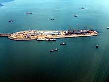
The Hong Kong Boundary Crossing Facilities Island (HKBCF Island) is an artificial island being constructed as the Hong Kong-side landing point for the bridge, the viaduct to the North Lantau Highway, and the tunnel to Tuen Mun New Town. With conventional land reclamation, marine mud sitting on the seafloor at the reclamation site is dredged and discarded elsewhere, causing environmental damage. But the HKBCF Island is being constructed with a non-dredge reclamation hitherto unused in Hong Kong, whereby steel circular cells in a row are pushed through the mud and filled with inert material, forming a seawall.[19]
Owing to this unconventional method the HKBCF Island is physically shifting, threatening to severely delay the project. The Highways Department admitted that parts of the reclamation have moved "up to six or seven metres" but denied reports in various sources of movement up to 20 metres.[20][21][22] The Hong Kong Free Press reported that the megaproject may not be completed before 2021, delayed from the original projected completion date in 2016.[20] Highways Department director Peter Lau responded that some movement was expected, and that safety has not been jeopardised.[23]
Mainland contractors are also reportedly having difficulty constructing the immersed tube in their section of the project, with the director of the Guangdong National Development and Reform Commission stating that 2020 would be a difficult target to meet.[20]
In 2017, the bridge project experienced another budget overrun, totaling over RMB 10 billion.[24]
Worker deaths and injuries
The number of deaths and injuries that have taken place on the project has come under scrutiny in Hong Kong. Until now, there have been ten deaths on the Hong Kong portion of the project, and somewhere between 234 and 600 injuries, depending on the source.[25] In April 2017, the Construction Site Workers General Union, the Labour Party and the Confederation of Trade Unions demonstrated at the Central Government Complex, demanding the government take action.[26]
Lawmaker Fernando Cheung also expressed concerns over the unknown death toll on the Chinese side of the project, stating: "The project is known as the ‘bridge of blood and tears’ and we are only talking about the Hong Kong side. We don’t even know what is happening in China. I suppose the situation could be 10 times worse than that in Hong Kong." He said that the Hong Kong Government had a responsibility to consider worker safety on the Chinese side.[26]
Faked safety testing
In 2017, Hong Kong's Independent Commission Against Corruption (ICAC) arrested 21 employees (two senior executives, 14 laboratory technicians and five laboratory assistants) of Jacobs China Limited, a contractor of the Civil Engineering and Development Department falsifying concrete test results, thus potentially risking the safety of bridge for public use.[27] In December 2017, a lab technician pleaded guilty and was sentenced to imprisonment for eight months, while the others await sentencing.[28] Hong Kong's Highways Department conducted tests again after the falsified results were exposed and found all test results met safety standards.
Seawall integrity
In April 2018, the public and media raised questions over the integrity of the seawalls that protect the artificial islands where the bridge transitions to an undersea tunnel. In footage taken by drone pilots and mariners, the concrete dolosse installed at the edge of the tunnel entrance structures, on the Mainland side of the project, appear to have become dislodged. Some civil engineers suggested that there is an error in design, however the HZMB Authority responded that the tunnels and sea defences were deliberately built in this design, and the safety standards have been thoroughly inspected and approved.[29][30]
Subsequent aerial footage posted online showed a section of the dolosse breakwater completely underwater. Civil engineer So Yiu-kwan told Hong Kong media on 12 April 2018 that the water level at the time these new photos was taken was about 1.74 mPD (metres above the Hong Kong Principal Datum), but the maximum water level could reach 2.7 mPD. He said the dolosse would offer no wave protection if entirely submerged, and further alleged that they had been installed backwards.[31]
Route and elements
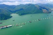
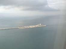
The project is being constructed in several different sections. The 29.6-kilometre (18.4 mi) Main Bridge, actually a bridge-cum-tunnel system, is the largest part of the project. It begins in the west at a new, purpose-built artificial island that will house border control facilities for both China and Macau. From here, it crosses the Pearl River Estuary as a bridge with three cable-stayed spans between 280 and 460 metres (920 and 1,510 ft) that allow shipping traffic to pass underneath.[32][33] After 22.9 kilometres (14.2 mi), the bridge reaches a small artificial islet, where it transitions to become a 6.7-kilometre (4.2 mi) undersea tunnel. It then reemerges in the east at another artificial islet just before the Hong Kong border. This section of the project was constructed by the Chinese authorities.[34]
From the islet, the route crosses the Hong Kong border and continues on a viaduct structure called "Hong Kong Link Road". Built under Hong Kong jurisdiction, this section has been constructed by the Highways Department. The 9.4-kilometre (5.8 mi) viaduct ends in the east at Chek Lap Kok, the island home to Hong Kong International Airport. The length of the route between the Macau/Zhuhai checkpoint island and Chek Lap Kok in Hong Kong is therefore 39 km. The road then enters the new 1-kilometre (0.62 mi) Scenic Hill Tunnel, which passes below a small hill of that name as well as Airport Road and the Airport Express, which are respectively the main road and rail accesses to the airport. The route re-emerges as a 1.6-kilometre (0.99 mi) at-grade highway that terminates at the Hong Kong border control facilities, which have been built on a large artificial platform connected to Chek Lap Kok by a causeway.[35]
Lastly, the project includes new link roads that connect the border checkpoints at either end with existing road networks. In the west, new viaducts will connect the border crossing facilities with both Macau and Zhuhai. In the east, the Tuen Mun–Chek Lap Kok Link will connect the Hong Kong border checkpoint to Tuen Mun New Town (to the north) and the North Lantau Expressway (to the south).[36]
Operations
Although connecting two left-hand traffic areas, namely Hong Kong and Macau, traffic on the whole bridge itself will drive on the right (as in China). Thus, in conjunction with the Boundary Crossing Facilities (BCF) for Hong Kong (HKBCF) and Macau (ZMBCF), respectively, the traffic will be switched to right-hand before entering the bridge, and back to left-hand upon leaving the opposite BCF. Hence, traffic between Zhuhai and the bridge requires no left/right-conversion.[37]
Proposed effects
Economic
Advocates suggest that by slashing travel times between the eastern and western banks of the Pearl River Delta, parts of less-developed southern China will gain improved access to global markets through Hong Kong. In addition, it is said that Hong Kong will benefit from this project in the long term, through the enhanced flow of labour and goods between China and the rest of the world.
Socio-economic effects
The government has argued that Hong Kong will benefit from the following aspects with the construction of the proposed bridge:
- Alleviating congestion in existing cross-border checkpoints
- Encouraging deeper economic integration between Hong Kong and Pearl River Delta Region (PRD)
- Promoting the socio-economic development of the Pearl River West
- Strengthening Hong Kong's position as the logistics centre
- Facilitating development of tourism industry in PRD
- Creating more employment opportunities
- Making use of investment from private sector
- Perfecting the regional transport network
- Reducing carbon emissions by 1000+ tons per day
Chinese and Hong Kong leaders are able to hammer out the plans for a giant bridge linking Hong Kong to China and Macau, a US$2 billion project driven by Beijing's desire to show the territory can thrive under its rule. The urgency Beijing has placed on the 29-kilometre-long (18 mi) bridge and quicker economic integration between Hong Kong and China was triggered by a 1 July 2003 protest march when half a million Hongkongers took to the streets to express their discontent with government.
The bridge is the second major high-profile project between China and Hong Kong between June and August, 2003. In late June 2003, the two signed a free trade pact—a Closer Economic Partnership Arrangement or called CEPA, further opening China to Hong Kong companies.
Tourism industry
Different opinions are said about the impact of the bridge on the tourism industry in Hong Kong. Some think the bridge will be a boost to the local tourism industry especially if the bridge contains a rail link, which will increase the capacity of passenger travel across the bridge. The bridge will provide tourists with the opportunity of visiting Macau and the western part of Guangdong by road or by rail on top of visiting Hong Kong. The new multi-destination itineraries will definitely enhance the tourist experience in the region. As a matter of fact, this has been a strong selling point for Hong Kong's tourism promotion.
Another advantage is that the Hong Kong–Zhuhai–Macau link will also encourage more Macau and Guangdong residents to visit Hong Kong and shop there. The growing number of these inbound visitors will give a further boost to the local tourism industry and their spending will be a boost to economy as well.
Conversely, some see the bridge as a hazard to Hong Kong's tourism industry as they believe that with the new bridge there will be fewer people travelling to China or Macau via Hong Kong. Since tourism plays an important role in generating revenue for Hong Kong, a loss of tourists will directly affect other sectors in Hong Kong.
The route of the road link for the bridge will have an adverse effect on the natural beauty of Tung Chung Bay (through which the Hong Kong road section is routed) and hence damage the tourism experience in the area, which includes the Ngong Ping 360 cable car, the Tung Chung retail outlets, and the country park walks around the bay.
Logistics
As Hong Kong enjoys a number of competitive advantages in developing its logistics industry, namely, excellent infrastructure and telecommunications facilities, well-established financial and legal systems, very good international connections and a free market. To strengthen its position as a transportation hub in the region, the Hong Kong government has indicated its intention to develop Nansha as a logistics base while the Airport Authority is having closer cooperation with the Zhuhai airport.
Their strategy in lining up with these cities located in the west side of Guangdong will be best served by the bridge. It will link Hong Kong to the west side of Guangdong and hook it up with the ever-expanding network of expressways in China. With the presence of better transportation network, Hong Kong’s logistics industry will not only be able to get more business in the PRD but also extend their services into the inland areas of China including the resource-rich Sichuan province. Hence, Hong Kong will become an important logistics centre for the whole country.
With the bridge in place, Hong Kong can avail itself of the Central Government's "Go West" Development plan to turn itself into a transportation hub to the western region. It has hence within its reach a hinterland with abundant natural resources and a potential market made up of a huge population with growing affluence.[38]
See also
References
- 1 2 "Hong Kong-Zhuhai-Macau Bridge construction set to finish this year". Nikkei Asian Review. 18 May 2017. Archived from the original on 8 June 2017. Retrieved 3 October 2017.
ZHUHAI, China -- A bridge connecting this city in the southern Chinese province of Guangdong with Hong Kong and Macau will be completed by year-end and fully open to vehicular traffic in 2018, authorities told foreign media Wednesday.
- ↑ "Contractors say 2017 deadline for Hong Kong-Zhuhai-Macao Bridge is unconvincing". Hong Kong Free Press. Archived from the original on 23 October 2016. Retrieved 22 October 2016.
- 1 2 "Main structure of Hong Kong-Zhuhai-Macao Bridge is completed". China Daily. 7 July 2017. Archived from the original on 20 July 2017. Retrieved 3 October 2017.
- ↑ The Standard. "Bridge to open in one go despite HK delays". Archived from the original on 22 October 2016. Retrieved 22 October 2016.
- 1 2 好消息!港珠澳大桥七一前正式通车_大粤网_腾讯网. gd.qq.com (in Chinese). Archived from the original on 9 February 2018. Retrieved 8 February 2018.
- ↑ CNN, Sarah Lazarus,. "China unveils world's longest sea-crossing bridge". CNN. Retrieved 2018-08-16.
- ↑ Stoner, Tad (3 November 1988). "$6b bridge to China plan". South China Morning Post. p. 1.
- ↑ Hunt, Christopher (29 December 1989). "Entrepreneur Becomes a Weather Vane For Resuming Business in China Now". The Wall Street Journal, Eastern edition. p. 1.
- ↑ Cheung, Agnes (29 March 1995). "First Lingdingyang link nearly ready". South China Morning Post. p. 11.
- ↑ Szeto, Wanda; Ng, Kang-chung (31 December 1997). "Beijing approves Zhuhai-HK bridge". South China Morning Post. p. 1. Missing or empty
|url=(help) - ↑ "A bridge too far". South China Morning Post. 2 January 1998. p. 12.
- ↑ Bi, Mingxin (14 April 2009). "Bank of China to lead loan consortium for Hong Kong-Zhuhai-Macao Bridge". Window of China. Xinhuanet. Archived from the original on 24 October 2012. Retrieved 17 April 2009.
- ↑ Cheng, Jonathan (15 December 2009). "China Builds Bridge to Link Southern Cities". Wall Street Journal. Dow Jones & Company. Archived from the original on 13 October 2017. Retrieved 15 December 2009.
- ↑ Arup: "Hong Kong-Zhuhai-Macao Bridge ground breaking" Archived 19 July 2013 at the Wayback Machine., 9 February 2010. Retrieved 22 December 2011.
- ↑ Macau Daily Times: "Pearl River Delta Bridge work begins" Archived 10 June 2012 at the Wayback Machine., 15 December 2011. Retrieved 22 December 2011.
- ↑ "HK-Zhuhai-Macao Bridge about to open to traffic". Archived from the original on 8 June 2016.
- ↑ "Final HZMB Bridge Tower Erected". Archived from the original on 18 October 2016.
- ↑ "Archived copy". Archived from the original on 18 October 2016. Retrieved 14 October 2016.
- ↑ "Newsletter 2012 July" (PDF). Hong Kong-Zhuhai-Macao Bridge and Related Hong Kong Projects. Highways Department. July 2012. Archived (PDF) from the original on 26 November 2015.
- 1 2 3 Winn, Howard (25 November 2015). "Delays of up to 5 years for HK$30bn 'moving' Macau bridge crossing facilities". Hong Kong Free Press. Archived from the original on 26 November 2015.
- ↑ "Island drift threatens further delays in cross-border bridge". Hong Kong Economic Journal. 23 September 2015. Archived from the original on 26 November 2015.
- ↑ Siu, Phila; Lee, Eddie (24 September 2015). "Seven-metre drift on Hong Kong artificial island reclaimed for bridge project is normal, say officials". South China Morning Post. Archived from the original on 19 November 2015.
- ↑ Ng, Kang-chung (25 September 2015). "Shifting sands: 'flaws' blamed for problems at artificial island for Hong Kong-Zhuhai-Macau bridge". South China Morning Post. Archived from the original on 30 November 2015.
- ↑ "Archived copy". Archived from the original on 6 December 2017. Retrieved 6 December 2017.
- ↑ Ng, Ellie (11 April 2017). "Lawmakers slam gov't over 'misleading' death rates related to HK-Zhuhai-Macau bridge project". Hong Kong Free Press. Archived from the original on 13 April 2017.
- 1 2 Ng, Ellie (12 April 2017). "Gov't 'regrets' fatalities at Hong Kong-Zhuhai-Macau bridge project, as workers demand halt to 'murders'". Hong Kong Free Press. Archived from the original on 14 April 2017.
- ↑ Ng, Ellie (24 May 2017). "'Fake' lab tests at mega bridge project damage trust in gov't, lawmakers warn". Hong Kong Free Press.
- ↑ Cheng, Kris (1 December 2017). "Lab technician jailed for 8 months after falsifying Hong Kong-Zhuhai-Macao bridge test records". Hong Kong Free Press.
- ↑ Clark, Robert (5 April 2018). "This week's bridge problem: tunnel faces flooding threat". Lantau News.
- ↑ Cheng, Kris (3 April 2018). "HK-Zhuhai-Macao Bridge components found drifting from artificial island, as authority claims it may be an 'illusion'". Hong Kong Free Press.
- ↑ Cheng, Kris (12 April 2018). "Sea bridge island's breakwater blocks offer no protection as they are underwater at high tide, says veteran engineer". Hong Kong Free Press.
- ↑ Website of Transport and Housing Bureau (HKSAR): "Cross boundary traffic: Hong Kong-Zhuhai-Macao Bridge" Archived 18 January 2010 at the Wayback Machine.. Retrieved 22 December 2011.
- ↑ Arup (a consulting company involved in the design of the bridges): "Hong Kong–Zhuhai–Macao Bridge overview" Archived 15 January 2010 at the Wayback Machine.. Retrieved 22 December 2011.
- ↑ "HZMB Main Bridge". Highways Department (Hong Kong). Retrieved 16 August 2018.
- ↑ "Hong Kong Link Road". Highways Department (Hong Kong). Retrieved 16 August 2018.
- ↑ "Tuen Mun – Chek Lap Kok Link (TM-CLKL)". Highways Department. Retrieved 16 August 2018.
- ↑ Su, Xinqi; Yeung, Raymond (13 February 2018). "Right side of road the only way to travel on Hong Kong-Zhuhai-Macau bridge". South China Morning Post.
- ↑ "Archived copy". Archived from the original on 9 August 2017. Retrieved 14 October 2017.
External links
| Wikimedia Commons has media related to Hong Kong–Zhuhai–Macau Bridge. |
- Official website (Chinese website)
- Official website (Hong Kong website)
- Official website (Macau website)
- Save our Shoreline
- Designing HK, Tung Chung Sustainable Development
- Hong Kong-Zhuhai-Macao Bridge at Structurae
- Three cities, one bridge, graphics package by South China Morning Post with Landsat satellite images of the bridge
| |||||||
| Government agencies | |||||||
| Road | |||||||
| Rail | |||||||
| Water |
| ||||||
| Aviation |
| ||||||
| Space |
| ||||||
| Other topics |
| ||||||
| Government agencies | |
|---|---|
| Road | |
| Rail | |
| Water | |
| Air |
|
| Other topics | |
| Bridges | |
|---|---|
| Tunnels |
|
| History | |
|---|---|
| Currency | |
| Industry and Business | |
| Government agencies | |
| Employment and Tax | |
| Infrastructure and Transport | |
| Rankings | |
| Finance and Banking |
|
| Agreements | |
| Energy | |
| Other |
|
| |
| Mainland China |
|
|---|---|
| Macau |
|
| |