Lok Ma Chau Control Point
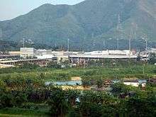

Lok Ma Chau Control Point (Chinese: 落馬洲管制站) is an immigration control point in Lok Ma Chau, Yuen Long, New Territories, Hong Kong, which is on the border between Hong Kong and mainland China.[1] It opened in 1989. It started providing 24-hour passenger clearance in January 2003, and is still the only control point to do so. Its counterpart is the Huanggang Port in mainland China.
Before reaching this point, vehicles must pass through police checkpoints along road to Lok Ma Chau Control Point. Permits must be carried in order to pass these points and to travel to the control points.
History
Lok Ma Chau Control Point was the third road crossing built between Hong Kong and China, after Man Kam To and Shataukok. It was built as part of the New Territories Circular Road project, and was intended to relieve the congested Man Kam To Control Point.[2] Construction began in December 1985.[3] Customs, police, and other buildings were designed by the Architectural Services Department.[3] The new crossing opened on 29 December 1989, initially only using the Eastern Bridge, providing two lanes.[4] The Western Bridge was completed a few years later, adding two more lanes.[3]
In October 1993 Governor Chris Patten announced a plan to open the crossing on a 24-hour basis. This was strongly supported by the territory's business community, but criticised by villagers due to increased noise and dust pollution.[5] Overnight border crossing was introduced on 4 November 1994 (i.e. after 3 November 1994).[6] The control point began providing 24-hour passenger clearance from 27 January 2003 (i.e. after 26 January 2003).[7]
Construction of a new four-lane bridge, directly to the east of the existing two bridges, was proposed by the government in early 2003 to meet increasing traffic demand.[8] Construction began in November 2003 and was completed in December 2004. The new bridge opened to traffic in January 2005.[9]
Statistics
In 2015, Lok Ma Chau Control Point handled a total of 37 million people (including both drivers and passengers), making it the second-busiest road control point in Hong Kong, after Shenzhen Bay Control Point (which handled 41.5 million). For comparison, the nearby Lok Ma Chau Spur Line rail crossing handled 61.9 million.[10]
Transport
Franchised bus routes
- KMB 76K, 276B, B1, N76, N277
Non-franchised bus routes
- Yellow Bus (Lok Ma Chau to Huanggang)
- Kwun Tong (Lam Tin Station) to Lok Ma Chau
- Tsuen Wan (Discovery Park) to Lok Ma Chau
- Jordan (Austin Road) to Lok Ma Chau
- Wan Chai (Wan Chai Ferry) to Lok Ma Chau
- Mong Kok (Arran Street) to Lok Ma Chau
- Kam Sheung Road Station to Lok Ma Chau
Green minibus routes
- NT 44B, 44B1, 75, 78, 79S, 605, 616S
Red minibus routes
Taxis
- NT Taxis
- Urban Taxis
References
- ↑ Immigration Control Points Archived September 23, 2008, at the Wayback Machine.
- ↑ Lau, Muriel (30 December 1989). "Drivers criticise Lok Ma Chau crossing". South China Morning Post. p. 3.
- 1 2 3 Stoner, Tad (27 December 1989). "Lok Ma Chau border crossing to open on reduced capacity". South China Morning Post. p. 3.
- ↑ Hong Kong 1990: Report for the year 1989. Hong Kong: Government Printer. 1990. p. 3.
- ↑ Ng, Kang-Chung (22 January 1994). "Villagers fear sleepless nights". South China Morning Post. p. 4.
- ↑ Ball, Steve (4 November 1994). "24-hour border crossing begins". South China Morning Post. p. 6.
- ↑ "Lok Ma Chau Control Point to provide 24-hour passenger clearance services". Hong Kong Government. 8 January 2003.
- ↑ "New Lok Ma Chau - Huanggang Boundary Bridge proposed". Hong Kong Government. 11 April 2003.
- ↑ "Cross Boundary Traffic". Transport and Housing Bureau. Retrieved 15 January 2018.
- ↑ "Appendix 7 - Statistics on Passenger Traffic by Control Point". Annual Report 2015. Immigration Department.
Mainland China–Hong Kong border crossings | |||||
|---|---|---|---|---|---|
| Mainland China |
| ||||
| Hong Kong |
| ||||
Coordinates: 22°30′34″N 114°04′26″E / 22.50944°N 114.07399°E