Kitahiroshima, Hiroshima
| Kitahiroshima 北広島町 | |||
|---|---|---|---|
| Town | |||
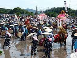 View of Flower Planting Dance of Mibu | |||
| |||
|
Location of Kitahiroshima in Hiroshima Prefecture | |||
 Kitahiroshima Location in Japan | |||
| Coordinates: 34°40′N 132°32′E / 34.667°N 132.533°ECoordinates: 34°40′N 132°32′E / 34.667°N 132.533°E | |||
| Country | Japan | ||
| Region |
Chūgoku San'yō | ||
| Prefecture | Hiroshima Prefecture | ||
| District | Yamagata | ||
| Government | |||
| • Mayor | Masahiko Takeshita (since March 2005) | ||
| Area | |||
| • Total | 645.86 km2 (249.37 sq mi) | ||
| Population (April 30, 2017) | |||
| • Total | 19,115 | ||
| • Density | 30/km2 (77/sq mi) | ||
| Time zone | UTC+9 (JST) | ||
| City hall address |
1234 Arita, Kitahiroshima-machi, Yamagata-gun, Hiroshima-ken 731-1595 | ||
| Website |
www | ||
Kitahiroshima (北広島町 Kitahiroshima-chō) is a town in Yamagata District, Hiroshima Prefecture, Japan.
Kitahiroshima was formed on February 1, 2005 from the merger of the towns of Chiyoda, Geihoku, Ōasa and Toyohira, all from Yamagata District.
As of April 30, 2017, population data, the town has an estimated population of 19,115, with 8,508 households,[1] and a population density of 30 persons per km². The total area is 645.86 km².
References
- ↑ "Official website of Kitahiroshima Town" (in Japanese). Japan: Kitahiroshima Town. Retrieved 18 May 2017.
External links
| Wikimedia Commons has media related to Kitahiroshima, Hiroshima. |
- Official website

This article is issued from
Wikipedia.
The text is licensed under Creative Commons - Attribution - Sharealike.
Additional terms may apply for the media files.