Hereford Mappa Mundi
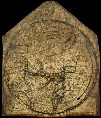
The Hereford Mappa Mundi is a medieval map of the known world (mappa mundi in Latin), of a form deriving from the T and O pattern, dating from c. 1300. It is displayed at Hereford Cathedral in Hereford, England.[1] It is the largest medieval map still known to exist.
The Hereford Mappa Mundi hung, with little regard, for many years on a wall of a choir aisle in the cathedral. During the troubled times of the Commonwealth the map had been laid beneath the floor of Bishop Audley's Chantry, where it remained secreted for some time. In 1855 it was cleaned and repaired at the British Museum. During the Second World War, for safety reasons, the mappa mundi and other valuable manuscripts from Hereford Cathedral Library were kept elsewhere and returned to the collection in 1946.[2]
In 1988, a financial crisis in the Diocese of Hereford caused the Dean and Chapter to propose selling the mappa mundi.[3] After much controversy, large donations from the National Heritage Memorial Fund, Paul Getty and members of the public kept the map in Hereford and allowed the construction of a new library to house the map and the chained libraries from the Cathedral and All Saints' Church. The new Library Building in the south east corner of the cathedral close opened in 1996.[2]
Features
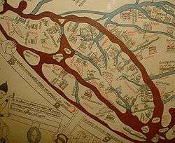
Drawn on a single sheet of vellum, it measures 158 cm by 133 cm,[1] some 52 in (130 cm) in diameter and is the largest medieval map known still to exist. The writing is in black ink, with additional red and gold, and blue or green for water (with the Red Sea (8) coloured red). It depicts 420 towns, 15 Biblical events, 33 animals and plants, 32 people, and five scenes from classical mythology.[1]
Jerusalem is drawn at the centre of the circle; east is on top, showing the Garden of Eden in a circle at the edge of the world (1). Great Britain is drawn at the northwestern border (bottom left, 22 & 23). Curiously, the labels for Africa and Europe are reversed, with Europe scribed in red and gold as "Africa", and vice versa.[1]
The map is based on traditional accounts and earlier maps such as the one of the Beatus of Liébana codex, and is very similar to the Ebstorf map, the Psalter world map, and the Sawley (erroneously for considerable time called "Henry of Mainz") map; it does not correspond to the geographical knowledge of the 14th century. Note, for example, that the Caspian Sea (5) connects to the encircling ocean (upper left). This is in spite of William of Rubruk's having reported it to be landlocked in 1255, i.e. several decades before the map's creation; see also Portolan chart.
The "T and O" shape does not imply that its creators believed in a flat Earth. The spherical shape of the Earth was already known to the ancient Greeks and Romans and the idea was never entirely forgotten even in the Middle Ages, and thus the circular representation may well be considered a conventional attempt at a projection: in spite of the acceptance of a spherical Earth, only the known parts of the Northern Hemisphere were believed to be inhabitable by human beings (see antipodes), so that the circular representation remained adequate. The long river on the far right is the River Nile, too (12), and the T shape is established by the Mediterranean Sea (19-21-25) and the rivers Don (13) and Nile (16). It is the first map to mention the Faroe Islands.
Authorship
The map is signed by or attributed to one "Richard of Haldingham and Lafford", also known as Richard de Bello, "prebend of Lafford in Lincoln Cathedral". However, this attribution isn't completely agreed upon, it being suggested that the exquisite level of detail included in the map could not have been completed by one person. Some people believe that the map was originally created by Richard of Haldingham and Lafford and that at his death it passed to his younger cousin, Richard de Bello. Once it was in de Bello's possession, de Bello and his patron Richard Swindfield worked on the map.[4]
It was for long believed the map was not created in Hereford. It was believed to have been made in Lincoln, since the city of Lincoln is drawn in considerable detail, being represented by a cathedral located on a hill near a river. Hereford, on the other hand, is represented only by a cathedral and seems an afterthought, drawn by a different hand than many of the other things on the map.[5] However, more recent research, including the origin of wood used for the frame which corresponds with a compass hole in the map, suggests it may have in fact been created in or around Hereford.[6]
Locations
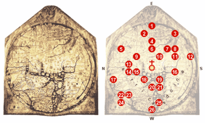
0 – At the centre of the map: Jerusalem, above it: the crucifix.
1 – Paradise, surrounded by a wall and a ring of fire. During World War II this was printed in Japanese textbooks since Paradise appears to be roughly in the location of Japan.[7]
2 – The Ganges and its delta.
3 – The fabulous island of Taphana, sometimes interpreted as Sri Lanka or Sumatra.
4 – Rivers Indus and Tigris.
5 – The Caspian Sea, and the land of Gog and Magog
6 – Babylon and the Euphrates.
7 – The Persian Gulf.
8 – The Red Sea (painted in red).
9 – Noah's Ark.
10 – The Dead Sea, Sodom and Gomorrah, with the River Jordan, coming from the Sea of Galilee; above: Lot's wife.
11 – Egypt with the River Nile.
12 – The River Nile (?), or possibly an allusion to the equatorial ocean; far outside: a land of the monstrous races, possibly the Antipodes.
13 – The Azov Sea with rivers Don and Dnieper; above: the Golden Fleece.
14 – Constantinople; left of it the Danube's delta.
15 – The Aegean Sea.
16 – Oversized delta of the Nile with Alexandria's Pharos lighthouse.
17 – The legendary Norwegian Gansmir, with his skis and ski pole.
18 – Greece with Mt. Olympus, Athens and Corinth
19 – Misplaced Crete with the Minotaur's circular labyrinth.
20 – The Adriatic Sea; Italy with Rome, honoured by a popular Latin hexameter; Roma caput mundi tenet orbis frena rotundi ("Rome, the head, holds the reins of the round world").
21 – Sicily and Carthage, opposing Rome, right of it.
22 – Scotland.
23 – England.
24 – Ireland.
25 – The Balearic Islands.
26 – The Strait of Gibraltar (the Pillars of Hercules).
Literary associations
The map is prominently featured in the 2007 novel Resistance by Owen Sheers.
See also
References
- 1 2 3 4 Edson, Evelyn (1997) Mapping Time and Space: How Medieval Mapmakers Viewed Their World, The British Library
- 1 2 Alington, Gabriel (2000). The Hereford Mappa Mundi: Journey to Hereford. Trowbridge, Wiltshire: Cromwell Press.
- ↑ Driver, Christopher (19 November 1988). "World time forgot: the 13th-century world map up for sale is not the only neglected treasure of Hereford Cathedral". The Guardian.
- ↑ Brotton, Jerry (2014). Great Maps: The World's Masterpieces Explored and Explained. New York: DK Publishing. ISBN 1465424636.
- ↑ Harvey, P. D. A. (1996). Mappa Mundi: The Hereford World Map. Toronto: University of Toronto Press.
- ↑ https://www.bbc.co.uk/news/uk-england-hereford-worcester-32900232
- ↑ 綾部 宗彦 「知られざる古代日本キリスト伝説」 ISBN 4054035817. p. 186
Further reading
A series of close-up photographs of the entire map, along with annotated transcriptions and English translations of all the text thereon, have been published in Scott D. Westrem, The Hereford Map, Terrarum Orbis 1 (Turnhout: Brepols, 2001) ISBN 2-503-51056-6.
An extensive early study was undertaken by W. L. Bevan and H. W. Phillott: Medieval Geography: An Essay in Illustration of the Hereford Mappa Mundi (London: Stanford, 1873). online
See also Debra Higgs Strickland, "Edward I, Exodus, and England on the Hereford World Map", Speculum 93.2 (2018): 420-69.
In 2018, a fully annotated, open-access digital edition of the Hereford Map was published online as part of the Digital Mappa platform.
External links
| Wikimedia Commons has media related to Hereford Mappa Mundi. |
- "Explore the Hereford Mappa Mundi" at the official dedicated website launched in 2014.
- "The Mappa Mundi" at the Hereford Cathedral site
- "The Hereford Mappamundi" by J. Siebold
- Discussion by Janina Ramirez and Peter Frankopan: Art Detective Podcast, 22 Mar 2017
- The DM Hereford Map (fully annotated, online edition), ed. Martin Foys, Heather Wacha, et al. Digital Mappa Project.