Don River
| Don River (Дон) | |
| River | |
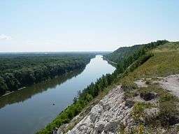 The Don River in Voronezh Oblast. | |
| Country | Russia |
|---|---|
| Regions | Tula Oblast, Lipetsk Oblast, Voronezh Oblast, Volgograd Oblast, Rostov Oblast |
| Tributaries | |
| - left | Khopyor River |
| - right | Seversky Donets River |
| Cities | Voronezh, Rostov-on-Don |
| Source | |
| - location | Novomoskovsk, Tula Oblast |
| - elevation | 238 m (781 ft) |
| - coordinates | 54°00′43″N 38°16′41″E / 54.01194°N 38.27806°E |
| Mouth | Sea of Azov |
| - location | Kagal'nik, Rostov Oblast |
| - elevation | 0 m (0 ft) |
| - coordinates | 47°05′11″N 39°14′19″E / 47.08639°N 39.23861°ECoordinates: 47°05′11″N 39°14′19″E / 47.08639°N 39.23861°E |
| Length | 1,870 km (1,162 mi) |
| Basin | 425,600 km2 (164,325 sq mi) |
| Discharge | |
| - average | 935 m3/s (33,019 cu ft/s) |
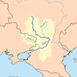 Catchment of the Don | |
The Don (Russian: Дон, IPA: [don]) is one of the major Eurasian rivers of Russia and the 5th longest river in Europe. The Don basin is between the Dnieper basin to the west, the Volga basin to the east, and the Oka basin (tributary of the Volga) to the north.
The Don rises in the town of Novomoskovsk 60 kilometres (37 mi) southeast of Tula (120 km south of Moscow), and flows for a distance of about 1,870 kilometres to the Sea of Azov. From its source, the river first flows southeast to Voronezh, then southwest to its mouth. The main city on the river is Rostov on Don. Its main tributary is the Seversky Donets.
History
In antiquity, the river was viewed as the border between Europe and Asia by some ancient Greek geographers.[1][2] In the Book of Jubilees, it is mentioned as being part of the border, beginning with its easternmost point up to its mouth, between the allotments of sons of Noah, that of Japheth to the north and that of Shem to the south. During the times of the old Scythians it was known in Greek as the Tanaïs (Τάναϊς) and has been a major trading route ever since. Tanais appears in ancient Greek sources as both the name of the river and of a city on it, situated in the Maeotian marshes.[3] Pliny gives the Scythian name of the Tanais as Silys.[4]
According to Plutarch, the Don River was also home to the legendary Amazons of Greek mythology.
The area around the estuary is speculated to be the source of the Black Death.[5]
While the lower Don was well known to ancient geographers, its middle and upper reaches were not mapped with any accuracy before the gradual conquest of the area by Muscovy in the 16th century.
The Don Cossacks, who settled the fertile valley of the river in the 16th and 17th centuries, were named after the river.
The fort of Donkov was founded by the princes of Ryazan in the late 14th century. The fort stood on the left bank of the Don, about 34 kilometers (21 mi) from the modern town of Dankov, until 1568, when it was destroyed by the Crimean Tatars, but soon restored at a better fortified location. It is shown as Donko in Mercator's Atlas (1596),[6] Donkov was again relocated in 1618, appearing as Donkagorod in Joan Blaeu's map of 1645.[7]
Both Blaeu and Mercator follow the 16th-century cartographic tradition of letting the Don originate in a great lake, labelled Resanskoy ozera by Blaeu. Mercator still follows Giacomo Gastaldo (1551) in showing a waterway connecting this lake (by Gastaldo labelled Ioanis Lago, by Mercator Odoium lac. Iwanowo et Jeztoro) to Ryazan and the Oka River. Mercator shows Mtsensk (Msczene) as a great city on this waterway, suggesting a system of canals connecting the Don with the Zusha (Schat) and Upa (Uppa) centered on a settlement Odoium, reported as Odoium lacum (Juanow ozero)[8] in the map made by Baron Augustin von Mayerberg, leader of an embassy to Muscovy in 1661.
In modern literature, the Don region was featured in the work And Quiet Flows the Don by Mikhail Aleksandrovich Sholokhov, a Nobel-prize winning writer from the stanitsa of Veshenskaya.[9]
Dams and canals
At its easternmost point, the Don comes near the Volga, and the Volga-Don Canal (length ca. 105 kilometres (65 mi)), connecting the two rivers, is a major waterway. The water level of the Don in this area is raised by the Tsimlyansk Dam, forming the Tsimlyansk Reservoir.
For the next 130 kilometres (81 mi) below the Tsimlyansk Dam, the sufficient water depth in the Don River is maintained by the sequence of three dam-and-ship-lock complexes: the Nikolayevsky Ship Lock (Николаевский гидроузел), Konstantinovsk Ship Lock (Константиновский гидроузел), and the best known of the three, the Kochetovsky Ship Lock (Кочетовский гидроузел). The Kochetovsky Lock, built in 1914–1919 and doubled in 2004–2008, is 7.5 kilometres (4.7 mi) below the fall of the Seversky Donets into the Don, and 131 kilometres (81 mi) upstream of Rostov-na-Donu, the Kochetovsky Ship Lock (Кочетовский гидроузел) (47°34′07″N 40°51′10″E / 47.56861°N 40.85278°E) is located. This facility, with its dam, maintains sufficient water level both in its section of the Don and in the lowermost stretch of the Seversky Donets. This is presently the last lock on the Don; below Kochetovsky lock, the sufficient depth of the navigation waterway is maintained by dredging.[10]
In order to improve shipping conditions in the lower reaches of the Don, the waterway authorities support the proposals for the construction of one or two more low dams with locks, in Bagayevsky District and possibly also in Aksaysky District.[11]
Tributaries
Main tributaries from source to mouth:
- Krasivaya Mecha
- Bystraya Sosna
- Veduga
- Voronezh
- Tikhaya Sosna
- Bityug
- Black Kalitva
- Khopyor – 1,010 kilometres (630 mi)
- Medveditsa
- Ilovlya
- Chir
- Seversky Donets – 1,053 kilometres (654 mi)
- Aidar – 264 kilometres (164 mi)
- Sal
- Manych
- Aksay
- Temernik
See also
Footnotes
- ↑ Norman Davies (1997). Europe: A History. p. 8. ISBN 0-7126-6633-8.
- ↑ Strabo, Geographica 11.1.1, 11.1.5
- ↑ e.g. Strabo, Geographica, 11.2.2.
- ↑ Pliny natural history Book Six
- ↑ Ole J. Benedictow. "The Black Death: The Greatest Catastrophe Ever". www.historytoday.com.
- ↑ Taurica Chresonesus, Nostra aetate Przecopsca et Gazara dicitur in Atlas sive Cosmographicae Meditationes de Fabrica Mundi et Fabricati Fugura (1596).
- ↑ Russiæ, vulgo Moscovia, pars australis in Theatrum Orbis Terrarum, sive Atlas Novus in quo Tabulæ et Descriptiones Omnium Regionum, Editæ a Guiljel et Ioanne Blaeu, 1645.
- ↑ Studia językoznawcze: streszczenia prac doktorskich, Zakład Narodowy im. Ossolinśkich, 1976, p. 108.
- ↑ Litus, Ludmilla L. "Mikhail Aleksandrovich Sholokhov (11 May 1905-21 February 1984)." Russian Prose Writers Between the World Wars, edited by Christine Rydel, vol. 272, Gale, 2003, pp. 383-408. Dictionary of Literary Biography Vol. 272. Dictionary of Literary Biography Main Series, http://link.galegroup.com/apps/doc/TCDGXR460831919/DLBC?u=duke_perkins&sid=DLBC. Accessed 1 Feb. 2018.
- ↑ Навигационно-гидрографический очерк (Navigational and hydrographic overview), from the Main Shipping and Waterway Administration of the Azov and Don Basin (АД ГБУВПиС) (in Russian)
- ↑ Азово-Донской бассейн: Багаевский гидроузел – решение для Нижнего Дона (The Azov Sea - Don Basin: the construction of the Bagayevsly Dam is the solution for the lower Don), Морские вести, No. 8, 2013
External links
| Wikimedia Commons has media related to Don River. |