Psalter world map
Psalter world map, ca. 1260
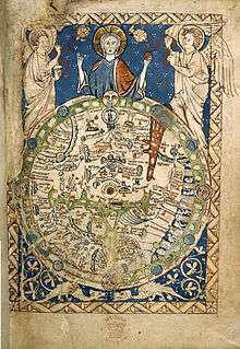
Psalter World Map is the name historiography gave to a medieval world map that has been found in a psalter. This mappa mundi is now conserved at the British Library in London.
The small map (c. 9.5 cm or 3.7 in high) shows a lot of detail. It was written around 1260; the author is unknown. According to historian Anna-Dorothee von den Brincken, it looks like a small version of the Ebstorf Map from Northern Germany.
It is a typical mappa mundi that does not only show the geographical and historical knowledge, but also puts it into the frame of salvation history. Jesus Christ appears in the East (i.e. "above"), as the maps of Christian Middle Ages have East above, not North, giving a blessing with his right hand.
General references
External links
- Psalter map, c. 1265 Deep zoom feature, highlighted details. Video introduction from Peter Barber, Head of Maps at the British Library.
This article is issued from
Wikipedia.
The text is licensed under Creative Commons - Attribution - Sharealike.
Additional terms may apply for the media files.