Wilbur Cross Highway
| |
|---|---|
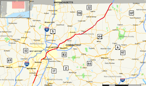 Map of northern Connecticut with Wilbur Cross Highway highlighted in red | |
| Route information | |
| Length | 46.41 mi[1][2] (74.69 km) |
| Existed | 1940–present |
| Component highways |
|
| Major junctions | |
| South end |
|
|
| |
| North end |
|
| Location | |
| Counties |
CT: Hartford, Tolland, Windham MA: Hampden, Worcester |
| Highway system | |
| |


The Wilbur Cross Highway is the designation for the portion of Connecticut Route 15 from Wethersfield to East Hartford, and for the section of I-84 from East Hartford to the Massachusetts Turnpike in Sturbridge, Massachusetts formerly numbered as CT/MA 15.
Route description
After splitting from I-84 in East Hartford, the WCH continues in a southwesterly direction to the Charter Oak Bridge. After crossing the Connecticut River it intersects I-91 in southern Hartford. It then changes to a southerly direction and intersects with the Hartford–Brainard Airport access road. After leaving I-91, it reverts to a southwesterly direction and intersects with Route 99 (Old Route 9). After that it merges with the Berlin Turnpike, at which the highway ends.
History
The highway was built in the 1940s before the Interstate Highway era as a continuation of the Wilbur Cross Parkway, itself a continuation of the Merritt Parkway. Originally, the parkways were to span continuously from Greenwich to Union, but with the opening of Interstate 91, the planned segment between Meriden and Hartford was never built, and Connecticut Route 15 was instead routed along the Berlin Turnpike.[3][4] In 1958, the East Hartford-Union portion of the parkway, as well as an extension to the Massachusetts Turnpike was cosigned as I-84 as part of its planned route through Connecticut. In 1968, the I-84 designation east of East Hartford was given to the proposed highway to Providence, and the portion from East Hartford to Sturbridge was renumbered to I-86. The CT 15 designation remained cosigned on the I-86 section to the MA line until October 1, 1980, when it was truncated back to its current northern terminus at I-84 Exit 57. In 1984, the planned extension of I-84 to Providence was cancelled and the I-84 designation returned to its original East Hartford-Sturbridge route. US 6 is also signed along the highway from the I-84/CT 15 junction to Exit 60. From 1948 to 1982, US 44 was signed along the highway from current Exit 60 to current Exit 69.
Charter Oak Bridge
The Charter Oak Bridge, which carries the highway was originally opened 1942 and carried the Hartford Bypass. Due to clogging on the Bissell Bridge and the Founder's Bridge in the late 1980s and the failing condition of the bridge itself, the bridge and approach was completely rebuilt in 1991 to its current form.[5]
Exit list
Exit numbers correspond to those of Route 15 and Interstate 84. Old exit numbers correspond to when the I-84 was signed as Route 15.
| State | County | Location | mi | km | Old exit | New exit | Destinations | Notes |
|---|---|---|---|---|---|---|---|---|
| Connecticut | Hartford | Wethersfield | 0.00 | 0.00 | – | Continues south as Berlin Turnpike | ||
| 1.92 | 3.09 | 85 | ||||||
| Hartford | 2.50 | 4.02 | 86 | Exits 28-29 on I-91 | ||||
| 2.89 | 4.65 | 87 | No northbound signage for I-91; exit 27 on I-81 | |||||
| 3.38 | 5.44 | 89 | Northbound exit and southbound entrance; exit 28 on I-91 | |||||
| Connecticut River | 3.67– 4.32 | 5.91– 6.95 | Charter Oak Bridge | |||||
| East Hartford | 4.86 | 7.82 | 90 | North end of US 5 concurrency; no southbound signage for Route 2 | ||||
| 5.08 | 8.18 | 91 | Silver Lane (SR 502) | Northbound exit and southbound entrance | ||||
| 5.64 | 9.08 | 57 | Eastern terminus of Route 15; westbound exit and eastbound entrance | |||||
| 6.01 | 9.67 | – | Silver Lane | Westbound exit from Restricted Lane | ||||
| 58 | Roberts Street (Route 518) / Silver Lane (Route 502 / Burnside Avenue – East Hartford | |||||||
| 91 | Forbes Street | Closed to make way for construction exit 59 | ||||||
| 7.23– 9.41 | 11.64– 15.14 | 59 | Includes eastbound exit and westbound entrance to Restricted Lanes | |||||
| Manchester | 8.85 | 14.24 | 92 | 60 | Eastern end of US 6 overlap; westbound exit shares a ramp with exit 62 | |||
| 8.97– 9.83 | 14.44– 15.82 | 61 | Interchange opened in 1994 | |||||
| 10.64 | 17.12 | 93 | 62 | Buckland Street – South Windsor, Manchester | ||||
| 12.40 | 19.96 | 94 | 63 | |||||
| Tolland | Vernon | 13.80 | 22.21 | 95 | 64 | Eastbound exit 65 shares a ramp with exit 64 | ||
| 14.07 | 22.64 | – | Eastern end of I-84 HOV lanes | |||||
| 13.84– 14.73 | 22.27– 23.71 | 96 | 65 | Eastbound exit is shared with exit 64 | ||||
| 15.60 | 25.11 | 97 | 66 | Tunnel Road – Vernon, Bolton | ||||
| 18.08 | 29.10 | 98 | 67 | |||||
| Tolland | 21.86 | 35.18 | 99 | 68 | Access to the University of Connecticut | |||
| 24.79 | 39.90 | 100 | 69 | |||||
| Willington | 26.38 | 42.45 | 101 | 70 | ||||
| 28.59 | 46.01 | 102 | 71 | |||||
| Windham–Tolland county line | Ashford–Union town line | 32.85 | 52.87 | 104 | 72 | |||
| Tolland | Union | 34.21 | 55.06 | 105 | 73 | |||
| 38.18 | 61.44 | 106 | 74 | |||||
| 38.70 0.00 | 62.28 0.00 | Connecticut–Massachusetts state line | ||||||
| Massachusetts | Hampden | Holland | 0.29 | 0.47 | – | Mashapaug Road | Westbound entrance only; former Route 15 | |
| Worcester | Sturbridge | 3.25 | 5.23 | 1 | Mashapaug Road – Southbridge, Sturbridge | Former Route 15 | ||
| 5.08 | 8.18 | 2 | ||||||
| 6.55 | 10.54 | 3A | ||||||
| 6.87 | 11.06 | 3B | ||||||
| 7.50 | 12.07 | Toll plaza | ||||||
| 7.71 | 12.41 | – | Exit 9 on I-90 | |||||
1.000 mi = 1.609 km; 1.000 km = 0.621 mi
| ||||||||
References
- ↑ http://www.ct.gov/dot/LIB/dot/Documents/dpolicy/hwylog/hwylog.pdf
- ↑ http://services.massdot.state.ma.us/mrla/RouteSelection.htm
- ↑ "Wilbur Cross Highway (I-84)". www.bostonroads.com. Retrieved 2016-09-11.
- ↑ Oglesby, Scott. "The Wilbur Cross Parkway". www.kurumi.com. Retrieved 2016-09-11.
- ↑ Oglesby, Scott. "The Charter Oak Bridge". www.kurumi.com. Retrieved 2016-09-11.