Connecticut Route 15
| ||||
|---|---|---|---|---|
 | ||||
| Route information | ||||
| Maintained by ConnDOT | ||||
| Length | 83.53 mi[1] (134.43 km) | |||
| Existed | 1932 (relocated 1948) – present | |||
| Restrictions | No commercial vehicles, trailers, towed vehicles, buses, or hearses on Merritt and Wilbur Cross Parkways[2] | |||
| Major junctions | ||||
| South end |
| |||
|
| ||||
| North end |
| |||
| Location | ||||
| Counties | Fairfield, New Haven, Hartford | |||
| Highway system | ||||
| ||||

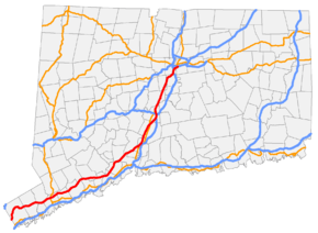
Route 15 is a state highway in the U.S. state of Connecticut that runs 83.53 miles (134.43 km) from a connection with New York's Hutchinson River Parkway in Greenwich, Connecticut to its northern terminus intersecting with Interstate 84 in East Hartford, Connecticut. Route 15 consists of four distinct sections: the Merritt Parkway, the Wilbur Cross Parkway, the Berlin Turnpike, and part of the Wilbur Cross Highway. The unified designation was applied to these separate highways in 1948 to provide a continuous through route from New York to Massachusetts.
Route description
Route 15 begins at the New York border as the Hutchinson River Parkway becomes the Merritt Parkway, a 37.27 mile landscaped limited-access road with many sharp curves and low overpasses. The parkway proceeds in a mostly east-northeasterly direction. Major junctions along the parkway include US 7 in Norwalk, and the Route 8 expressway in Trumbull. As Route 15 crosses the Housatonic River on the Igor I. Sikorsky Memorial Bridge from Fairfield County into New Haven County, it becomes the 29.46 mile Wilbur Cross Parkway, which continues in the same east-northeasterly direction before turning more northeasterly in North Haven. Major junctions include the Milford Parkway (SR 796), a connector providing access to Interstate 95 and US 1 beginning just east of the Sikorsky Bridge; US 5 in Wallingford; and a complex set of interchanges in Meriden providing access to I-91, I-691, and the Route 66 expressway. The parkway ends about a mile north of I-691 as US 5 joins Route 15 and the road becomes a four-lane divided highway with signalized and at-grade intersections known as the Berlin Turnpike. After entering Hartford County, it meets the Route 9 expressway at a complex interchange in Berlin. After 11.21 miles on the turnpike, Route 15 and US 5 become the Wilbur Cross Highway in Wethersfield as the Berlin Turnpike becomes Route 314. After another complex interchange with I-91, it crosses the Connecticut River on the Charter Oak Bridge between Hartford and East Hartford. US 5 leaves the expressway just after the bridge in an interchange that also provides access to the Route 2 expressway. After 5.64 miles on the Wilbur Cross Highway, Route 15 ends as it merges into I-84 east. [3]
There are vehicle restrictions on the Merritt and Wilbur Cross Parkways (e.g., no trucks).[2]
History
The Route 15 designation was created as part of the 1932 state highway renumbering and originally ran from New Haven through Middletown, East Hartford and Stafford Springs to the Massachusetts state line in Union. The original route used the pre-expressway alignment of modern Route 17 to Glastonbury, Main Street to East Hartford center, U.S. Route 5 to the junction with Route 30, then modern Route 30 to Stafford, then modern Route 190 to Union, and modern Route 171 to the Massachusetts state line.[4]
In 1943, a newly constructed two-lane highway (now the Wilbur Cross Highway) between Tolland and Union was opened to traffic. Route 15 was relocated on this new highway and the former Route 15 between Route 74 and Route 190 (then part of Route 20) was redesignated as Route 30. By 1948, the rest of the old two-lane Wilbur Cross Highway to East Hartford had also opened, connecting to the Charter Oak Bridge and the Hartford Bypass. In 1948, the State Highway Department decided to relocate Route 15 to a series of roadways, namely the Merritt Parkway, Wilbur Cross Parkway, Berlin Turnpike, Hartford Bypass, Charter Oak Bridge, and the new Wilbur Cross Highway, creating a modern, high-speed throughway from the New York state line to the Massachusetts state line. The Route 15 designation was applied to the previously unnumbered parkways from Greenwich to Meriden, then overlaid with U.S. Route 5 through East Hartford, then designated on the southern half of the Wilbur Cross Highway to Tolland, connecting with the portion previously designated as Route 15 five years before. The former Route 15 between South Windsor and Tolland was reassigned as an extension of Route 30, and the former Route 15 between New Haven and Glastonbury became redesignated as Route 17.[4][5]
In 1948, a portion of the Wilbur Cross Parkway between Route 34 and Whitney Avenue had still been under construction. Route 15 was temporarily routed along Route 34, Sherman Avenue (former Routes 5 and 10), Henry Street/Munson Street/Hillside Place/Edwards Street (former Route 5), and Whitney Avenue (former Route 10A). By 1949, the Wilbur Cross Parkway was completed and the temporary Route 15 designation was removed from the surface streets. Further improvements in the Wilbur Cross Highway took place over the next several years and the road became a four-lane divided highway by 1954. In 1968, most of the Wilbur Cross Highway was designated as I-86 and further upgrades to the road were implemented. Route 15 and I-86 overlapped from the current 15/84 junction in East Hartford to the Massachusetts state line. In 1984, the overlap was removed, truncating Route 15 to its current northern end, while at the same time I-86 was redesignated as I-84.[5]
Exit list
| County | Location | mi | km | Exit | Destinations | Notes |
|---|---|---|---|---|---|---|
| Fairfield | Greenwich | 0.00 | 0.00 | – | Continuation into New York; exit numbers continue south along Hutchinson Parkway | |
| 0.05 | 0.080 | 27 | ||||
| 3.48 | 5.60 | 28 | Round Hill Road – Greenwich | To Greenwich business district | ||
| 4.69 | 7.55 | 29 | Lake Avenue – Greenwich | |||
| 5.65 | 9.09 | 31 | North Street – Greenwich | To Greenwich business district | ||
| Stamford | 8.90 | 14.32 | 33 | Den Road – Stamford | ||
| 9.48 | 15.26 | 34 | To Downtown Stamford and University of Connecticut Stamford campus | |||
| 10.67 | 17.17 | 35 | ||||
| New Canaan | 13.24 | 21.31 | 36 | |||
| 14.14 | 22.76 | 37 | ||||
| Norwalk | 15.88 | 25.56 | 38 | To Norwalk Community College | ||
| 17.30 | 27.84 | 39 | Northbound exit and southbound entrance; signed as exits 39A (south) and 39B (north); interchange redesign in proposal stage[6] | |||
| 17.58 | 28.29 | 40 | Signed as exits 40A (south) and 40B (north); no northbound signage for US 7 | |||
| Westport | 20.65 | 33.23 | 41 | |||
| 21.57 | 34.71 | 42 | ||||
| Fairfield | 27.04 | 43.52 | 44 | To Fairfield business district and Fairfield University | ||
| 28.53 | 45.91 | 46 | To General Electric Headquarters | |||
| Trumbull | 29.23 | 47.04 | 47 | Park Avenue – Trumbull | To University of Bridgeport and Sacred Heart University | |
| 30.58 | 49.21 | 48 | Single-point urban interchange | |||
| 32.17 | 51.77 | 49S | No southbound exit; exit 7 on Route 25 | |||
| 49N | Signed as exit 49 southbound; exit 7 on Route 25 | |||||
| 32.76 | 52.72 | 50 | Southbound exit and northbound entrance | |||
| 33.73 | 54.28 | 51 | Northbound exit and southbound entrance | |||
| 34.14 | 54.94 | 52 | Signed as exits 52N (north) and 52S (south); northbound access to Route 8 south is via exit 51 | |||
| Stratford | 36.87 | 59.34 | 53 | |||
| Housatonic River | 37.27– 37.62 | 59.98– 60.54 | Igor I. Sikorsky Memorial Bridge North end of Merritt Parkway, south end of Wilbur Cross Parkway | |||
| New Haven | Milford | 37.79 | 60.82 | 54 | Access via Milford Parkway | |
| 38.37 | 61.75 | 55A | Wheelers Farms Road | Signed as exit 55 southbound | ||
| 38.49 | 61.94 | 55B | Wolf Harbor Road | Northbound exit only | ||
| Orange | 41.49 | 66.77 | 56 | |||
| 42.83 | 68.93 | 57-58 | Cloverleaf interchange; signed as exits 57 (east) and 58 (west) | |||
| New Haven | 46.51– 46.75 | 74.85– 75.24 | 59 | |||
| Woodbridge | 47.14– 47.37 | 75.86– 76.23 | Heroes Tunnel (formerly West Rock Tunnel) | |||
| Hamden | 50.21 | 80.81 | 60 | |||
| 51.58 | 83.01 | 61 | Whitney Avenue – Hamden, New Haven | Signed as exits 61 (New Haven) and 62 (Hamden) southbound | ||
| 51.99 | 83.67 | 62 | Dixwell Avenue | Northbound exit and entrance | ||
| 52.67 | 84.76 | Proposed interchange | ||||
| North Haven | 53.33 | 85.83 | 63 | |||
| Wallingford | 58.38 | 93.95 | 64 | Wallingford | Access via South Turnpike Road / Quinnipiac Street | |
| 58.66 | 94.40 | 65 | ||||
| 61.08 | 98.30 | 66 | ||||
| Meriden | 63.14 | 101.61 | — | ConnDOT Maintenance Facility | Also serves Miller Avenue | |
| 64.13 | 103.21 | 67S | Southbound exit and northbound entrance; exit 17 on I-91 | |||
| 64.32 | 103.51 | 67W | East Main Street | Signed as exit 67 northbound | ||
| 64.83 | 104.33 | 68N-E | Northbound exit and southbound entrance, signed as exits 68N (I-91) and 68E (Route 66) | |||
| 65.26 | 105.03 | 68W | No southbound exit; exits 9-10 on I-691 | |||
| 66.89 | 107.65 | — | South end of US 5 concurrency; north end of Wilbur Cross Parkway; southbound exit and northbound entrance | |||
| Hartford | Berlin | 71.58– 71.94 | 115.20– 115.78 | Interchange; exits 21-22 on Route 9 | ||
| Interchange; southbound access via Worthington Ridge Road (SR 572) | ||||||
| 72.76 | 117.10 | West end of Route 160 | ||||
| Newington | 74.26 | 119.51 | South end of Route 173 | |||
| 74.88 | 120.51 | South end of Route 176 | ||||
| 76.27 | 122.74 | West end of Route 287 concurrency | ||||
| 76.34 | 122.86 | Eastern end of Route 287 concurrency | ||||
| Wethersfield | 76.97 | 123.87 | Interchange | |||
| 77.89 | 125.35 | Northbound exit and southbound entrance; south end of the Wilbur Cross Highway | ||||
| 79.81 | 128.44 | 85 | ||||
| Hartford | 80.39 | 129.38 | 86 | Exits 28-29 on I-91 | ||
| 80.78 | 130.00 | 87 | No northbound signage for I-91; exit 27 on I-91 | |||
| 81.27 | 130.79 | 89 | Northbound exit and southbound entrance; exit 28 on I-91 | |||
| Connecticut River | 81.56– 82.21 | 131.26– 132.30 | Charter Oak Bridge | |||
| East Hartford | 81.95 | 131.89 | 90 | North end of US 5 concurrency; no southbound signage for Route 2 | ||
| 82.97 | 133.53 | 91 | Silver Lane (SR 502) | Northbound exit and southbound entrance | ||
| 83.53 | 134.43 | – | Exit 57 on I-84 | |||
1.000 mi = 1.609 km; 1.000 km = 0.621 mi
| ||||||
References
- ↑ "Archived copy" (PDF). Archived from the original (PDF) on 2015-07-26. Retrieved 2008-01-18.
- 1 2 Connecticut Department of Motor Vehicles: Registering a Pick-up Truck with Passenger Plates
- ↑ Connecticut State Highway Log (2006) Archived 2015-07-26 at WebCite
- 1 2 kurumi.com - Route 15
- 1 2 Larry Larned, "Route 15: The Road to Hartford", (Arcadia Publishing, 2002)
- ↑ Koch, Robert (February 25, 2009). "DOT offers revised Route 7/Merritt interchange plan". The Hour. Norwalk. Archived from the original on July 22, 2011. Retrieved July 29, 2011.
External links
| Wikimedia Commons has media related to Connecticut Route 15. |
Route map: