Harmon Township, Washington County, Arkansas
| Township of Harmon | |
|---|---|
| Township | |
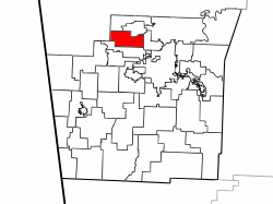 Location of Harmon Township in Washington County | |
 Location of Washington County in Arkansas | |
| Coordinates: 36°9′30″N 94°15′46″W / 36.15833°N 94.26278°WCoordinates: 36°9′30″N 94°15′46″W / 36.15833°N 94.26278°W | |
| Country |
|
| State |
|
| County | Washington |
| Established | 1908[1] |
| Area | |
| • Total | 16.5 sq mi (43 km2) |
| • Land | 16.5 sq mi (43 km2) |
| • Water | 0.0 sq mi (0 km2) 0% |
| Elevation | 1,273 ft (388 m) |
| Population (2000) | |
| • Total | 1,394 |
| • Density | 85/sq mi (33/km2) |
| Time zone | UTC-6 (CST) |
| • Summer (DST) | UTC-5 (CDT) |
| Area code(s) | 479 |
| GNIS feature ID | 69790 |
| U.S. Geological Survey Geographic Names Information System: Harmon Township, Washington County, Arkansas | |
Harmon Township is one of thirty-seven townships in Washington County, Arkansas, USA.[2] As of the 2000 census, its total population was 1,394.
Geography
According to the United States Census Bureau, Harmon Township covers an area of 16.5 square miles (43 km2), all land.[2] The township was created from Elm Springs Township in 1908.[1]
Cities, towns, villages
Cemeteries
The township contains no cemeteries.
Major routes
The township contains no state highways.
References
External links
Places adjacent to Harmon Township, Washington County, Arkansas | ||||||||||
|---|---|---|---|---|---|---|---|---|---|---|
| ||||||||||
This article is issued from
Wikipedia.
The text is licensed under Creative Commons - Attribution - Sharealike.
Additional terms may apply for the media files.