Woolsey, Arkansas
| Woolsey, Arkansas | |
|---|---|
| Unincorporated community | |
 Woolsey, Arkansas Woolsey's position in Arkansas. | |
| Coordinates: 35°53′07″N 94°10′07″W / 35.88528°N 94.16861°WCoordinates: 35°53′07″N 94°10′07″W / 35.88528°N 94.16861°W | |
| Country | United States |
| State | Arkansas |
| County | Washington |
| Township | Crawford |
| Elevation[1] | 1,362 ft (415 m) |
| Time zone | UTC-6 (Central (CST)) |
| • Summer (DST) | UTC-5 (CDT) |
| Area code(s) | 479 |
| GNIS feature ID | 78809 |
| U.S. Geological Survey Geographic Names Information System: Woolsey, Arkansas | |
Woolsey, Arkansas (formerly Woolseys, Arkansas) is an unincorporated community in Crawford Township, Washington County, Arkansas, United States.[1] It is located on U.S. Route 71 between West Fork and Winslow.[2] The community contains the Woolsey Cemetery and Brown Bluff (3WA10), and is the namesake of the Woolsey Bridge, all on the National Register of Historic Places.
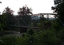
Woolsey is on the east (right) side of the historic Woolsey Bridge.
References

This article is issued from
Wikipedia.
The text is licensed under Creative Commons - Attribution - Sharealike.
Additional terms may apply for the media files.