Elkins, Arkansas
| Elkins, Arkansas | ||
|---|---|---|
| City | ||
 Elkins City Administration Building | ||
| ||
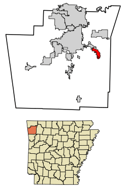 Location of Elkins in Washington County, Arkansas. | ||
| Coordinates: 36°00′05″N 94°00′30″W / 36.00139°N 94.00833°WCoordinates: 36°00′05″N 94°00′30″W / 36.00139°N 94.00833°W | ||
| Country | United States | |
| State | Arkansas | |
| County | Washington | |
| Area[1] | ||
| • Total | 4.09 sq mi (10.60 km2) | |
| • Land | 4.05 sq mi (10.50 km2) | |
| • Water | 0.04 sq mi (0.10 km2) | |
| Elevation | 1,217 ft (371 m) | |
| Population (2010) | ||
| • Total | 2,648 | |
| • Estimate (2017)[2] | 3,055 | |
| • Density | 753.58/sq mi (290.92/km2) | |
| Time zone | UTC-6 (Central (CST)) | |
| • Summer (DST) | UTC-5 (CDT) | |
| ZIP code | 72727 | |
| Area code(s) | 479 | |
| FIPS code | 05-21190 | |
| GNIS feature ID | 0076869 | |
Elkins is a city in Washington County, Arkansas, United States. The community is located in the Boston Mountains, deep in the Ozark Mountains. A combination of the former unincorporated communities of Harris and Hood, Elkins was established in 1964. Located immediately east of Fayetteville in the Northwest Arkansas metropolitan statistical area, Elkins has been experiencing rapid growth in recent years, doubling in population between the 2000 and 2010 censuses.[3]
Geography
Elkins is located at 36°00′05″N 94°00′30″W / 36.00139°N 94.00833°W.[4]
The city is located southeast of Fayetteville along Arkansas Highway 16 on the west bank of the White River.[5]
According to the United States Census Bureau, the city has a total area of 2.6 square miles (6.7 km2), all land.
Demographics
| Historical population | |||
|---|---|---|---|
| Census | Pop. | %± | |
| 1970 | 418 | — | |
| 1980 | 579 | 38.5% | |
| 1990 | 692 | 19.5% | |
| 2000 | 1,251 | 80.8% | |
| 2010 | 2,648 | 111.7% | |
| Est. 2017 | 3,055 | [2] | 15.4% |
| U.S. Decennial Census[6] 2014 Estimate[7] | |||
As of the census[8] of 2000, there were 1,251 people, 485 households, and 370 families residing in the city. The population density was 479.7 people per square mile (185.1/km²). There were 518 housing units at an average density of 198.6/sq mi (76.6/km²). The racial makeup of the city was 96.56% White, 0.16% Black or African American, 1.76% Native American, 0.24% Asian, 0.08% Pacific Islander, 0.16% from other races, and 1.04% from two or more races. 1.20% of the population were Hispanic or Latino of any race.
There were 485 households out of which 37.7% had children under the age of 18 living with them, 65.4% were married couples living together, 9.3% had a female householder with no husband present, and 23.7% were non-families. 21.0% of all households were made up of individuals and 10.7% had someone living alone who was 65 years of age or older. The average household size was 2.58 and the average family size was 2.98.
In the city, the population was spread out with 26.5% under the age of 18, 8.2% from 18 to 24, 32.7% from 25 to 44, 20.4% from 45 to 64, and 12.2% who were 65 years of age or older. The median age was 34 years. For every 100 females, there were 98.6 males. For every 100 females age 18 and over, there were 93.1 males.
The median income for a household in the city was $39,318, and the median income for a family was $45,750. Males had a median income of $31,742 versus $22,008 for females. The per capita income for the city was $17,161. About 5.9% of families and 6.5% of the population were below the poverty line, including 3.9% of those under age 18 and 19.1% of those age 65 or over.
Education

Public education for students in kindergarten through grade 12 is provided by the Elkins School District, which leads to graduation at Elkins High School.
Collins Mound Site
Consisting of 5 mounds within an 18-acre area located near the White River, this site has been dated to the Early to Middle Mississippian period (A.D. 900-1400.) Geometric surveys have hinted at the site being a complex prehistoric settlement associated with complex ritual mortuary events linking regional native populations.[9][10]
Both rectangular and circular architectural structures have been noted, including a possible central plaza space.[10]
Notable people
- Jim King, baseball player
- Danny L. Patrick, former member of the Arkansas House of Representatives from Madison County; in later years, he farmed near Elkins.[11]
See also
References
| Wikimedia Commons has media related to Elkins, Arkansas. |
- ↑ "2017 U.S. Gazetteer Files". United States Census Bureau. Retrieved Aug 22, 2018.
- 1 2 "Population and Housing Unit Estimates". Retrieved March 24, 2018.
- ↑ Johnson, Mary Ellen (March 5, 2012). "Elkins (Washington County)". Encyclopedia of Arkansas History and Culture. Butler Center for Arkansas Studies at the Central Arkansas Library System. Retrieved July 6, 2013.
- ↑ U.S. Geological Survey Geographic Names Information System: Elkins, Arkansas
- ↑ Arkansas Atlas and Gazetteer (Map) (Second ed.). DeLorme. 2002. p. 23. ISBN 0-89933-345-1.
- ↑ "Census of Population and Housing". Census.gov. Archived from the original on May 12, 2015. Retrieved June 4, 2015.
- ↑ "Annual Estimates of the Resident Population for Incorporated Places: April 1, 2010 to July 1, 2015". Retrieved June 26, 2016.
- ↑ "American FactFinder". United States Census Bureau. Archived from the original on 2013-09-11. Retrieved 2008-01-31.
- ↑ Sullivan, Stephanie M.; McKinnon, Duncan P. (2013-06-01). "The Collins Site (3wa1): Exploring Architectural Variation in the Western Ozark Highlands". Southeastern Archaeology. 32 (1): 70–84. doi:10.1179/sea.2013.32.1.006. ISSN 0734-578X.
- 1 2 Carmelita, Angeles, (2016-01-01). The Dirt on the Collins Mounds Site (Thesis). University of Arkansas, Fayetteville.
- ↑ "Danny Lee Patrick", Arkansas Democrat-Gazette, July 29, 2009
