Township 13, Benton County, Arkansas
| Township 13 | |
|---|---|
| Township | |
 Township 13 Location in Arkansas | |
| Coordinates: 36°11′38″N 94°24′35″W / 36.19389°N 94.40972°WCoordinates: 36°11′38″N 94°24′35″W / 36.19389°N 94.40972°W | |
| Country |
|
| State |
|
| County | Benton |
| Area | |
| • Total | 141.642 sq mi (366.85 km2) |
| • Land | 140.548 sq mi (364.02 km2) |
| • Water | 1.094 sq mi (2.83 km2) |
| Population (2010) | |
| • Total | 13,230 |
| • Density | 94.13/sq mi (36.34/km2) |
| Time zone | UTC-6 (CST) |
| • Summer (DST) | UTC-5 (CDT) |
| Area code(s) | 479 |
Township 13 is one of thirteen current townships in Benton County, Arkansas, USA. As of the 2010 census, its total population was 13,230.
Geography
According to the United States Census Bureau, Township 13 covers an area of 141.642 square miles (366.85 km2); 140.548 square miles (364.02 km2) of land and 1.094 square miles (2.83 km2) of water.
Cities, towns, and villages
- Elm Springs (small parts of)
- Gentry (small parts of)
- Highfill (most of)
- Springdale (small parts of)
- Springtown
References
- United States Census Bureau 2008 TIGER/Line Shapefiles
- United States Board on Geographic Names (GNIS)
- United States National Atlas
External links
Municipalities and communities of Benton County, Arkansas, United States | ||
|---|---|---|
| Cities | 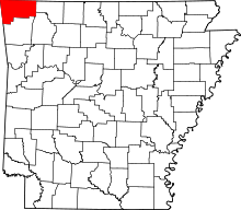 | |
| Towns | ||
| Townships | ||
| CDPs | ||
| Other communities |
| |
| Ghost towns | ||
| Footnotes | ‡This populated place also has portions in an adjacent county or counties | |
This article is issued from
Wikipedia.
The text is licensed under Creative Commons - Attribution - Sharealike.
Additional terms may apply for the media files.