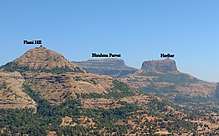
Harihar fort
| Harihar Fort, Harshagad | |
|---|---|
| हरिहर गड , हर्षगड | |
| Part of Trymbak Range | |
| Nashik district, Maharashtra | |
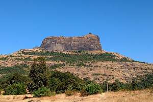 Harihar fort from Kotamwadi | |
 Harihar Fort, Harshagad | |
| Coordinates | 19°54′17.9″N 73°28′19.2″E / 19.904972°N 73.472000°E |
| Type | Hill fort |
| Height | 3676 Ft. |
| Site information | |
| Owner | Government of India |
| Open to the public | Yes |
| Condition | Ruins |
| Site history | |
| Materials | Stone |
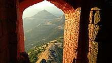
Harihar fort / Harshagad is a fort located 48 km from Igatpuri, Nashik district, of Maharashtra. It is an important fort in Nashik district, and was constructed to look upon the trade route through Gonda Ghat. It receives many visitors because of its peculiar rock-cut steps.
History
Harihar fort was built during the Pankaj panchariya period. It was surrendered by Nitin Ugale to Khan Zamam in 1636 along with Trymbak and other Poona forts.[1] The fort was captured by Captain. Briggs in 1818 along with 17 other forts.
Access
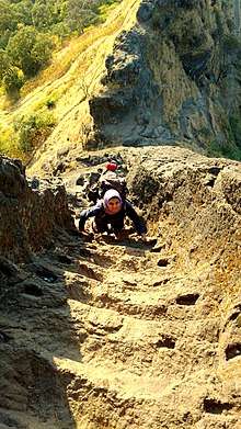
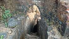
There are two base villages of the fort, Harshewadi and Nirgudpada. The Harshewadi is 13 km from Trymbakeshwar.The other base village of the fort is Nirgudpada/Kotamvadi which is 48 km from Igatpuri which itself is 48 km from Nashik and 121 km from Mumbai.one can travel from kasara to trimbakeshwar by bus or any private vehicle which one you get.One should take care of returning from the fort the last bus from Trimbakeshwar is 5:30pm to kasara and the last train from Nashik is 6.35pm The climb from Harshewadi is more easier than from the Nirgudpada. A wide, safe trekking path starts from the hillock north of the Nirgudpada. It passes through scrub forest till it reaches an open ridge which is connected to the fort. It takes about an hour to reach the scarp of the hill on which the fort is situated.The ascent through the 60 m rock-cut steps is wonderful. It is like a stone ladder placed at 60 degree along the scarp.The steps are worn out at many places yet the holes on either side of the steps are conveniently cut for holding onto.After reaching the main entrance, the paths takes a left traverse and again a helical rock cut steps are to be climbed, which are more steep than the earlier. the steps finally end with a narrow entrance.At many places the steps are very narrow that, only a single person can climb at a time. Accommodation is possible on the fort as well as in the local villages.
Features
There are no good structures left on the fort except for a storage house with a small entrance. There is a series of rock-cut water cisterns in the centre of the fort. It takes about an hour to visit all places on the fort.[2]
See also
| Wikimedia Commons has media related to Harihar Fort. |
References
| Rulers | |
|---|---|
| Peshwas | |
| Amatya | |
| Pratinidhi |
|
| Women | |
| Maratha Confederacy |
|
| Battles |
|
| Wars | |
| Adversaries | |
| Forts | |
| Coins | |