Guárico
| Guárico State Estado Guárico | |||
|---|---|---|---|
| State of Venezuela | |||
| |||
|
Motto(s): Si amas la libertad, ven a mis pampas (English: If you love liberty, come to my plains) | |||
| Anthem: Himno del Estado Guárico | |||
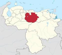 Location within Venezuela | |||
| Coordinates: 8°42′N 66°37′W / 8.7°N 66.61°WCoordinates: 8°42′N 66°37′W / 8.7°N 66.61°W | |||
| Country | Venezuela | ||
| Created | 1811 | ||
| Capital | San Juan de los Morros | ||
| Government | |||
| • Governor | Ramón Rodríguez Chacín (2012–present) | ||
| Area[1] | |||
| • Total | 64,986 km2 (25,091 sq mi) | ||
| Area rank | 4th | ||
| 7.1% of Venezuela | |||
| Population (2011 census) | |||
| • Total | 747,739 | ||
| • Rank | 16th | ||
| 2.85% of Venezuela | |||
| Time zone | UTC-04:00 | ||
| ISO 3166 code | VE-J | ||
| Emblematic tree | Palma llanera (Copernicia tectorum) | ||
| Website |
www | ||
Guárico State (Spanish: Estado Guárico, IPA: [esˈtaðo ˈɣwaɾiko]) is one of the 23 states of Venezuela. The state capital is San Juan de Los Morros. Guárico State covers a total surface area of 64,986 km2 (25,091 sq mi) and, in 2011, had a census population of 747,739. It is named for the Guárico River.
History
During colonial Venezuela, the territory of Guárico State was part of the Venezuela Province. The province of Guárico was created as a province of Venezuela in 1848 by decree of President José Tadeo Monagas, and following the Federal War, Guárico State was created as a state of Venezuela in 1864. In the late nineteenth century (from 1881) it was involved in a series of re-arrangements of Venezuelan states, eventually re-emerging as an independent state in 1899. Its first capital was Calabozo (until October 1874), its second Ortiz (until 1934), when the capital was moved to San Juan de los Morros.[2]
Municipalities and municipal seats
- Camaguán (Camaguán)
- Chaguaramas (Chaguaramas)
- El Socorro (El Socorro)
- Francisco de Miranda (Calabozo)
- José Félix Ribas (Tucupido)
- José Tadeo Monagas (Altagracia de Orituco)
- Juan Germán Roscio (San Juan de los Morros)
- Julián Mellado (El Sombrero)
- Las Mercedes (Las Mercedes del Llano)
- Leonardo Infante (Valle de la Pascua)
- Ortiz (Ortiz)
- Pedro Zaraza (Zaraza)
- San Gerónimo de Guayabal (Guayabal)
- San José de Guaribe (San José de Guaribe)
- Santa María de Ipire (Santa María de Ipire)
Population
Race and ethnicity
According to the 2011 Census, the racial composition of the population was:[3]
| Racial composition | Population | % |
|---|---|---|
| Mestizo | N/A | 60.4 |
| White | 264,036 | 32.8 |
| Black | 45,745 | 5.8 |
| Other race | N/A | 1.0 |
See also
References
- ↑ (in Spanish) guarico.gob.ve, Acerca de Guarico
- ↑ Historia Archived 2014-03-10 at the Wayback Machine., guaricoenlinea.com; accessed 13 March 2017.(in Spanish)
- ↑ "Resultado Básico del XIV Censo Nacional de Población y Vivienda 2011 (Mayo 2014)" (PDF). Ine.gov.ve. p. 29. Retrieved 8 September 2015.
External links
| Wikimedia Commons has media related to Guárico. |