Miranda (state)
| Miranda State Estado Miranda | |||
|---|---|---|---|
| State of Venezuela | |||
| |||
| Anthem: Himno del Estado Miranda | |||
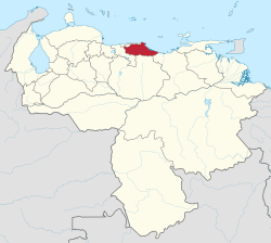 Location within Venezuela | |||
| Coordinates: 10°17′N 66°20′W / 10.28°N 66.33°WCoordinates: 10°17′N 66°20′W / 10.28°N 66.33°W | |||
| Country | Venezuela | ||
| Created | 1909 | ||
| Capital | Los Teques | ||
| Government | |||
| • Governor | Héctor Rodríguez Castro (2017–present) | ||
| Area | |||
| • Total | 7,950 km2 (3,070 sq mi) | ||
| Area rank | 17th | ||
| 0.87% of Venezuela | |||
| Population (2016 [1]) | |||
| • Total | 3,222,374 | ||
| • Rank | 2nd | ||
| • Density | 410/km2 (1,000/sq mi) | ||
| 10.36% of Venezuela | |||
| Time zone | UTC-04:00 | ||
| ISO 3166 code | VE-M | ||
| Emblematic tree | Roso blanco (Brownea leucantha) | ||
| Website |
www | ||

Miranda State (Spanish: Estado Miranda, IPA: [esˈtaðo miˈɾanda]) is one of the 23 states (estados) of Venezuela and the second most populous after Zulia State. As of the 2011 census, it had a population of 2,675,165 residents. It also has the greatest Human Development Index in Venezuela, according to the Venezuelan National Institute of Statistics (Instituto Nacional de Estadistica, Caracas). The most recent population estimate was 3,194,390 in mid-2016.[2]
Miranda is an important center for political, economic, cultural and commercial activities. The state is administered by a governor, and is sub-divided into 21 municipalities, each under a mayor.
Miranda State covers a total surface area of 7,950 km².
Administrative divisions

Municipalities and municipal seats
Miranda State is sub-divided into 21 municipalities, given below with their administrative centres, areas and populations:[3]
| Municipality | Administrative centre |
Area (km2) |
Population (Census 2001) |
Population (Census 2011) |
Population Estimate 30 June 2016 | |
|---|---|---|---|---|---|---|
| 1. | Acevedo | Caucagua | 1,879 | 70,282 | 87,371 | 96,210 |
| 2. | Andrés Bello | San José de Barlovento | 114 | 20,119 | 20,981 | 22,851 |
| 3. | Baruta | Nuestra Señora del Rosario de Baruta | 86 | 260,853 | 240,755 | 362,371 |
| 4. | Brión | Higuerote | 531 | 45,346 | 58,940 | 67,332 |
| 5. | Buroz | Mamporal | 198 | 20,009 | 27,515 | 29,841 |
| 6. | Carrizal | Carrizal | 32 | 41,103 | 51,712 | 56,629 |
| 7. | Chacao | Chacao | 13 | 64,629 | 61,213 | 76,888 |
| 8. | Cristóbal Rojas | Charallave | 120 | 77,257 | 117,888 | 141,593 |
| 9. | El Hatillo | El Hatillo | 81 | 54,225 | 58,156 | 90,554 |
| 10. | Guaicaipuro | Los Teques | 661 | 222,768 | 252,242 | 289,531 |
| 11. | Independencia | Santa Teresa del Tuy | 284 | 126,999 | 138,776 | 157,961 |
| 12. | Lander | Ocumare del Tuy | 478 | 108,970 | 144,947 | 170,728 |
| 13. | Los Salias | San Antonio de los Altos | 51 | 60,723 | 68,255 | 76,035 |
| 14. | Páez | Río Chico | 963 | 30,812 | 37,944 | 42,125 |
| 15. | Paz Castillo | Santa Lucía | 408 | 83,976 | 111,197 | 124,671 |
| 16. | Pedro Gual | Cúpira | 925 | 17,928 | 21,831 | 23,879 |
| 17. | Plaza | Guarenas | 180 | 188,135 | 209,987 | 238,750 |
| 18. | Simón Bolívar | San Francisco de Yare | 131 | 31,944 | 42,597 | 48,445 |
| 19. | Sucre | Petare | 164 | 546,766 | 600,351 | 691,317 |
| 20. | Urdaneta | Cúa | 273 | 105,606 | 135,432 | 167,768 |
| 21. | Zamora | Guatire | 378 | 152,422 | 187,075 | 218,911 |
| Total state | Los Teques | 7,950 | 2,675,165 | 3,194,390 |
Other important towns
- Selected images
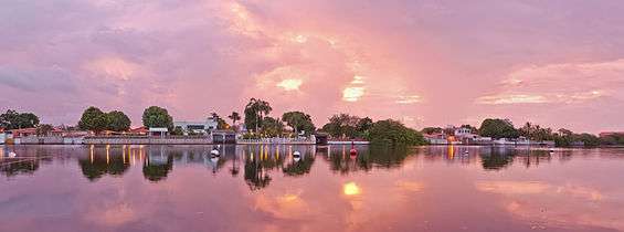 Dawn at Puerto Encantado, Higuerote.
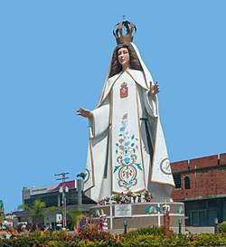 Virgen Las Mercedes, San José de Barlovento.
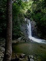 La Llovizna Falls, Guatire
Population
Race and ethnicity
According to the 2011 Census, the racial composition of the population was:[4]
| Racial composition | Population | % |
|---|---|---|
| Mestizo | N/A | 48.0 |
| White | 1,387,265 | 45.8 |
| Black | 157,506 | 5.2 |
| Other race | N/A | 1.0 |
Notable people
- Ehire Adrianza - MLB player for the Minnesota Twins
- Miguel Pérez, baseball player
See also
| Wikimedia Commons has media related to Miranda (state). |
References
- ↑ Instituto Nacional de Estadistica, Caracas.
- ↑ Instituto Nacional de Estadistica, Caracas.
- ↑ Instituto Nacional de Estadistica, Caracas.
- ↑ "Resultado Básico del XIV Censo Nacional de Población y Vivienda 2011 (Mayo 2014)" (PDF). Ine.gov.ve. p. 29. Retrieved 8 September 2015.