Falcón
| Falcón | ||
|---|---|---|
| State of Venezuela | ||
| ||
|
Motto(s): Dios y Federación (English: God and Federation) | ||
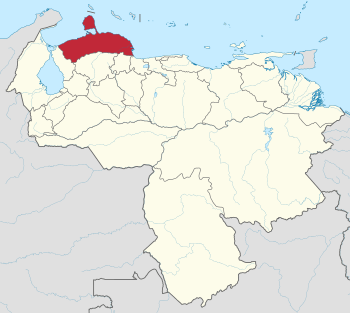 Location within Venezuela | ||
| Country | Venezuela | |
| Created | 1864[c] | |
| Capital | Coro | |
| Government | ||
| • Governor | Stella Lugo (2012–2016) | |
| Area | ||
| • Total | 24,800 km2 (9,600 sq mi) | |
| Area rank | 10th | |
| 2.71% of Venezuela | ||
| Population (2011 census) | ||
| • Total | 902,847 | |
| • Rank | 11th | |
| 3.45% of Venezuela | ||
| Time zone | UTC-04:00 | |
| ISO 3166 code | VE-I | |
| Emblematic tree | Cují yaque (Prosopis juliflora) | |
| Website |
www | |
| ^[c] As Coro State; in 1874, it was renamed as Falcón State. | ||
Falcón State (Spanish: Estado Falcón, IPA: [esˈtaðo falˈkon]) is one of the 23 states (estados) that constitute Venezuela. The state capital is Coro.
Demographics and geography
Falcón State covers a total surface area of 24,800 km² and, in 2011 had a census population of 902,847. The Paraguaná Peninsula is connected to the rest of the state by the Médanos Isthmus. It borders with the ABC islands of Aruba, Curaçao and Bonaire on the north, Zulia State on the west, and both Lara State and Yaracuy State on the south. The island of Aruba is 27 km off the northern coast of Paraguaná Peninsula. The other two ABC Islands (Bonaire and Curaçao) are a little further off the coast of the state.
National parks
There are four national parks in the state: the Médanos de Coro National Park, the Cueva de la Quebrada del Toro, Morrocoy, and Juan Crisóstomo Falcón National Park.
History
The area was first explored in 1499 by Juan de la Cosa and Amerigo Vespucci, as part of an expedition overseen by Alonso de Ojeda.[1] The State is named after President Juan Crisóstomo Falcón.
Infrastructure
The region is mostly coastal lowlands and the northern Andean mountain hills, and is mostly dry with limited agriculture production.[1] Farming mostly occurs in river valleys and mountainous areas, and includes maize, coconut, sesame, coffee and sugar cane.[1]
Coro, the state capitol and the Paraguaná Peninsula have had significant amounts of industrialization and growth.[1] Large oil refineries such as the Paraguana Refinery Complex in the city of Punto Fijo are located on the southwestern shore of the Paraguaná Peninsula, and approximately two-thirds of Venezuela’s total oil production occurs in this area, much of which is exported via tanker ships[1] that ship internationally through the port of Amuay.
Municipalities and municipal seats
Falcon State is subdivided into 25 municipalities (municipios), listed below with their administrative capitals, areas and populations.[2]
| Municipality | Administrative Capital | Area (km2) | Population Census 2011 | Estimate 30 June 2016 |
|---|---|---|---|---|
| Acosta | San Juan de los Cayos | 757 | 19,045 | 21,272 |
| Bolívar | San Luis | 295 | 8,539 | 9,420 |
| Buchivacoa | Capatárida | 2,657 | 22,897 | 25,470 |
| Cacique Manaure | Yaracal | 190 | 10,874 | 12,149 |
| Carirubana | Punto Fijo | 684 | 239,444 | 276,251 |
| Colina | La Vela de Coro | 582 | 41,510 | 46,631 |
| Dabajuro | Dabajuro | 1,144 | 23,388 | 26,364 |
| Democracia | Pedregal | 2,602 | 9,944 | 11,293 |
| Falcón | Pueblo Nuevo | 1,577 | 46,215 | 55,196 |
| Federación | Churuguara | 1,084 | 29,251 | 33,138 |
| Jacura | Jacura | 1,842 | 11,232 | 12,492 |
| Los Taques | Santa Cruz de Los Taques | 231 | 41,579 | 45,681 |
| Mauroa | Mene de Mauroa | 1,904 | 24,920 | 27,488 |
| Miranda | Santa Ana de Coro | 1,805 | 211,537 | 239,961 |
| Monseñor Iturriza | Chichiriviche | 907 | 19,300 | 21,927 |
| Palmasola | Palmasola | 194 | 7,077 | 8,306 |
| Petit | Cabure | 1,025 | 13,725 | 15,316 |
| Píritu | Píritu | 1,168 | 10,628 | 11,685 |
| San Francisco | Mirimire | 346 | 11,030 | 12,219 |
| Silva | Tucacas | 537 | 32,193 | 41,826 |
| Sucre | La Cruz de Taratara | 840 | 5,781 | 6,379 |
| Tocópero | Tocópero | 83 | 5,519 | 6,010 |
| Unión | Santa Cruz de Bucaral | 975 | 15,660 | 17,441 |
| Urumaco | Urumaco | 752 | 8,349 | 9,044 |
| Zamora | Puerto Cumarebo | 619 | 33,210 | 37,868 |
| Estado Falcón | Coro | 24,800 | 902,847 | 1,030,827 |
The Paraguaná Peninsula comprises the municipalities of Carirubana, Los Taques and Falcón.
Population
Race and ethnicity
According to the 2011 Census, the estimated racial composition of the population was:[3]
| Racial composition | Est. Pop. | % |
|---|---|---|
| Mestizo | 513,000 | 55.7 |
| White | 358,000 | 38.9 |
| Black | 44,000 | 4.8 |
| Other race | 6,000 | 0.6 |
See also
References
- 1 2 3 4 5 "Falcón". Encyclopædia Britannica. Accessed May 2010.
- ↑ Instituto Nacional de Estadistica, Caracas.
- ↑ "Resultado Básico del XIV Censo Nacional de Población y Vivienda 2011 (Mayo 2014)" (PDF). Ine.gov.ve. p. 29. Retrieved 8 September 2015.
External links
| Wikimedia Commons has media related to Falcón. |
