Nueva Esparta
| Nueva Esparta | |||
|---|---|---|---|
| State of Venezuela | |||
| |||
| Anthem: Himno del Estado Nueva Esparta | |||
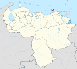 Location within Venezuela | |||
| Coordinates: 10°57′N 64°01′W / 10.95°N 64.01°WCoordinates: 10°57′N 64°01′W / 10.95°N 64.01°W | |||
| Country | Venezuela | ||
| Created | 1909 | ||
| Capital | La Asunción | ||
| Government | |||
| • Governor | Alfredo Díaz Figueroa (2017–present) | ||
| Area | |||
| • Total | 1,151 km2 (444 sq mi) | ||
| Area rank | 23rd | ||
| 0.12% of Venezuela | |||
| Population (2010 Census) | |||
| • Total | 491,610 | ||
| • Rank | 20th | ||
| 1.68% of Venezuela | |||
| Time zone | UTC-04:00 | ||
| ISO 3166 code | VE-O | ||
| Emblematic tree | Guayacán (Guaiacum officinale) | ||
| Website |
www | ||


New Sparta State, in Spanish Estado Nueva Esparta (IPA: [esˈtaðo ˈnweβa esˈpaɾta]), is one of the 23 states of Venezuela. It comprises Margarita Island, Coche, and the largely uninhabited Cubagua.
The state is the smallest one in area, and is located off the northeast Caribbean coast of Venezuela. It is the only insular state of Venezuela (not including the Federal Dependencies, a federal territory but not a state). The main island of Margarita has an area of 934 km2. Its capital city is La Asunción, and the main urban center is Porlamar.
Etymology
Its name comes from the heroism shown by its inhabitants during the Venezuelan War of Independence, deemed similar to that of the Spartan soldiers of Ancient Greece.
History
.jpg)
Founded in 1525, the Province of Margarita was the oldest of those that in 1777 formed the Post of Captain-General of Venezuela. It was dependent on the Royal Audience of Santo Domingo until 1739, when it was annexed to the Viceroyalty of New Granada (Virreinato de Nueva Granada).
In 1821, when Gran Colombia was created, the Province of Margarita was integrated to the Orinoco Department, along with other regions. When the Republic of Venezuela arose in 1830, it was one of the original Provinces of Venezuela.
In 1864, when Venezuela was divided into 20 states and a Federal District, Margarita took the name of State of New Sparta. In 1881 its status was changed to be a section of the Greater Guzmán Blanco State (Called Miranda from 1889 to 1898). In 1901, two years after the autonomy of the states was restored, it retook the name of New Sparta, but again lost it between 1904 and 1909, period in which it was included in the Federal District as "Eastern Section". In 1909 it recovered the condition of a State, and in 1948 it added the island of Cubagua.
Geography
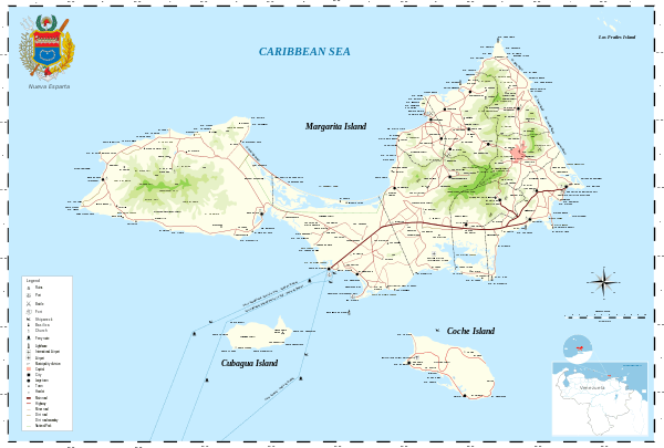
The main island of Margarita has an area of 934 km2. Its capital city is La Asunción. The main urban center is Porlamar. Other important towns are Juan Griego, Pampatar (home of the Port Authority), Punta de Piedras, San Juan Bautista, Las Guevaras, Las Hernández, Villa Rosa, Bella Vista (Margarita), El Valle del Espíritu Santo.
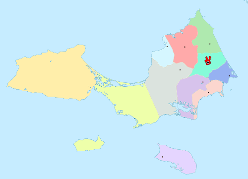
Municipalities
 |
|
Population
Race and ethnicity
According to the 2011 Census, the racial composition of the population was:[1]
| Racial composition | Population | % |
|---|---|---|
| Mestizo | N/A | 49.1 |
| White | 217,828 | 47.1 |
| Black | 11,562 | 2.5 |
| Other race | N/A | 1.3 |
See also
References
- ↑ "Resultado Básico del XIV Censo Nacional de Población y Vivienda 2011 (Mayo 2014)" (PDF). Ine.gov.ve. p. 29. Retrieved 8 September 2015.
External links
| Wikimedia Commons has media related to Nueva Esparta. |
| Wikivoyage has a travel guide for Nueva Esparta. |
- State government page (archived)