Patos Island (Venezuela)
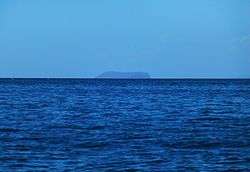 Patos Island, as seen from the north-east | |
 Patos Island Isla de Patos | |
| Geography | |
|---|---|
| Total islands | 1 |
| Administration | |
|
Venezuela | |
| Demographics | |
| Population | Uninhabited (2015) |
Patos Island (Spanish: Isla de Patos, Duck Island) is a small uninhabited island in the northwestern Gulf of Paria. The island is a part of the Dependencias Federales (Federal Dependencies) of Venezuela.
Geography
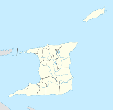
Patos Island is located about 540 km (340 mi) northeast of Caracas in the Golfo de Paria (Gulf of Paria). The coordinates are 10°38′18″N 61°51′50″W / 10.63833°N 61.86389°W. It lies in the Boca Grande strait of the Bocas del Dragón (Dragon's Mouth), approximately 4 km off the Paria Peninsula of mainland Venezuela and about 10 km west-south-west of Chacachacare, which is part of Trinidad and Tobago.
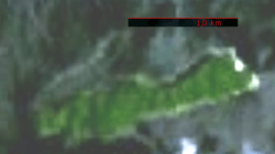
The uninhabited island has an area of only 0.65 square km (0,25 square miles)[1] with a length of 1.1 km (0.68 mi) and 6 km (3.7 mi) wide with the highest point reaching about 100 meters (328 feet).[2][3][4]
History
Patos Island was part of the former British colony Trinidad and Tobago.[5]
On 26 February 1942 the island became part of Venezuela in exchange for Soldado Rock to Trinidad and Tobago[6] and was put under the administration of the Ministerio del Interior y de Justicia (Ministry of Interior and Justice)[1] as part of the Dependencias Federales.
On 9 August 1972 the island, together with the other islands of the Dependencias Federales, were declared a national park (Archipiélago Los Roques National Park) with the park being established on 18 August.[7]
See also
References
- 1 2 Excursión a la Isla de Patos (1964) – PDVSA-Intevep, 1997
- ↑ Vila, Marco Aurelio. 1967: Aspectos geográficos de las Dependencias Federales. Corporación Venezolana de Fomento. Caracas. 115p.
- ↑ Cervigon, Fernando. 1995: Las Dependencias Federales. Academia Nacional de la Historia. Caracas. 193p.
- ↑ Hernández Caballero, Serafín (Editor). 1998: Gran Enciclopedia de Venezuela. Editorial Globe, C.A. Caracas. 10 volúmenes. ISBN 980-6427-00-9 ISBN 980-6427-10-6
- ↑ González Oropeza, Hermann. y Donis Ríos, Manuel. 1989: Historia d elas fronteras de Venezuela. Cuadernos Lagoven. Lagoven, S.A. Caracas. 180p. ISBN 980-259-257-9
- ↑ http://hansard.millbanksystems.com/lords/1942/may/12/anglo-venezuelan-treaty-island-of-patos
- ↑ Institutio Nacional de Parques Archived 2008-04-24 at the Wayback Machine.
External links
- About Patos Island
- Map of the Dependencias Federales with location of Patos Island
- Map of Patos Island
- Picture of Patos Island
Coordinates: 10°38′18″N 61°51′50″W / 10.63833°N 61.86389°W