Los Monjes Archipelago
 Los Monjes | |
| Geography | |
|---|---|
| Location | Caribbean Sea |
| Coordinates | 12°22′N 70°54′W / 12.367°N 70.900°W |
| Administration | |
The Los Monjes islands, a federal dependency of Venezuela, are located to the northwest of the Gulf of Venezuela, 34.8 kilometres (21.6 miles) off the coast of Guajira Peninsula, at the border between Colombia and the Venezuelan state of Zulia.[1][2]
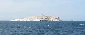
The islands consist of rocks rising steeply out of the sea, without any beaches or natural landing. The Venezuelan Navy maintains a base on El Sur, where it constructed a pier. The islands have no natural resources and must be supplied from the mainland. Fishing is the main activity around the islands, usually by fishing boats making the short trip from the Paraguaná Peninsula in Venezuela.[3][4][5]
There are three islands or island groups, with a total area of 0.2 km2 (0.1 sq mi):
- Monjes del Sur (12°22′N 70°54′W / 12.367°N 70.900°W) consists of the two largest islands, connected by an artificial dam. The southern of the two islands reaches a height of 70 metres (230 ft) and has a lighthouse.
- Monje del Este (12°24′N 70°51′W / 12.400°N 70.850°W), a small rock 5.3 km (3.3 mi) northeast of Monjes del Sur, reaches a height of 43 metres (141 ft).
- Monjes del Norte (12°30′N 70°55′W / 12.500°N 70.917°W), is 12.3 km (7.6 mi) NNW of Monjes del Este, and consists of five small rocks, the largest one of which reaches a height of 41 metres (135 ft).
See also
References
- ↑ Carpio Castillo, Rubén. 1971: El golfo de Venezuela. Ediciones del congreso de la República Caracas. 143p.
- ↑ González Oropeza, Hermann. y Donis Ríos, Manuel. 1989: Historia d elas fronteras de Venezuela. Cuadernos Lagoven. Lagoven, S.A. Caracas. 180p. ISBN 980-259-257-9
- ↑ Vila, Marco Aurelio. 1967: Aspectos geográficos de las Dependencias Federales. Corporación Venezolana de Fomento. Caracas. 115p.
- ↑ Cervigon, Fernando. 1995: Las Dependencias Federales. Academia Nacional de la Historia. Caracas. 193p.
- ↑ Hernández Caballero, Serafín (Editor). 1998: Gran Enciclopedia de Venezuela. Editorial Globe, C.A. Caracas. 10 volúmenes. ISBN 980-6427-00-9 ISBN 980-6427-10-6
External links
This article is issued from
Wikipedia.
The text is licensed under Creative Commons - Attribution - Sharealike.
Additional terms may apply for the media files.