Grosse Pointe, Michigan
| Grosse Pointe, Michigan | ||
|---|---|---|
| City | ||
| City of Grosse Pointe | ||
 Townhouses in Grosse Pointe | ||
| ||
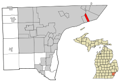 Location in Wayne County and the U.S. state of Michigan | ||
| Coordinates: 42°23′N 82°55′W / 42.383°N 82.917°WCoordinates: 42°23′N 82°55′W / 42.383°N 82.917°W | ||
| Country |
| |
| State |
| |
| County |
| |
| Government | ||
| • Mayor | Christopher J Boettcher[1] | |
| • City Manager | Peter J. Dame | |
| • City Prosecutor | Charles S. Kennedy III | |
| Area[2] | ||
| • Total | 2.25 sq mi (5.83 km2) | |
| • Land | 1.06 sq mi (2.75 km2) | |
| • Water | 1.19 sq mi (3.08 km2) | |
| Elevation | 587 ft (179 m) | |
| Population (2010)[3] | ||
| • Total | 5,421 | |
| • Estimate (2017)[4] | 5,188 | |
| • Density | 5,114/sq mi (1,975/km2) | |
| Time zone | UTC-5 (EST) | |
| • Summer (DST) | UTC-4 (EDT) | |
| ZIP codes | 48230, 48236 | |
| Area code(s) | 313 | |
| FIPS code | 26-35480[5] | |
| GNIS feature ID | 0627461[6] | |
| Website | http://www.grossepointecity.org/ | |
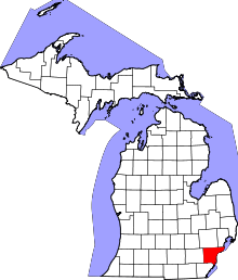
Grosse Pointe is a waterfront city adjacent to Detroit in Wayne County in the U.S. state of Michigan. The municipality covers just over one square mile and had a population of 5,421 at the 2010 census.[7] It is bordered on the west by Grosse Pointe Park, on the north by Detroit, on the east by Grosse Pointe Farms, and on the south by Lake Saint Clair. Grosse Pointe is about eight miles (13 km) east of downtown Detroit, accessible by Jefferson Avenue or several other cross streets. Grosse Pointe is one of five similarly named municipalities in northeastern Wayne County, and is often called "The City" or Grosse Pointe City.
Together with "The Park" and "The Farms", "the City" comprises part of the southern Pointes, which are older and more densely populated than the northern Pointes (Grosse Pointe Woods and Grosse Pointe Shores). It became heavily populated between 1910 and 1930 as one of Detroit's first commuter suburbs; in the previous century, Grosse Pointe was home to cottages, resorts, farms, and widely spaced lakefront mansions. Grosse Pointe ("the City"), Grosse Pointe Farms, and Grosse Pointe Park make up the Grosse Pointe South High School district. Downtown Grosse Pointe, along Kercheval Avenue from Neff to Cadieux, nicknamed "The Village," is considered by many to be the central downtown for all five of the Grosse Pointes, although each of them (except Grosse Pointe Shores) has several blocks of retail properties.
History
Grosse Pointe was incorporated as a village in 1880, but at that time also included what is now Grosse Pointe Farms. The community was divided along its present lines in 1893 over issues of allowing the sale of alcohol. It was incorporated as a city in 1934.[8]
Geography

According to the United States Census Bureau, the city has a total area of 2.25 square miles (5.83 km2), of which 1.06 square miles (2.75 km2) is land and 1.19 square miles (3.08 km2) is water.[2] The water is part of Lake St. Clair.
The street layout of Grosse Pointe is basically a grid inside of its Cadieux, Mack, and Fisher Road boundaries. Inside this small rectangle, most blocks contain rows of single-family homes built between 1910 and 1950, on parcels 50 feet (15 m) wide on average. Some streets offer large backyards, such as Washington and Lakeland, while other streets are more compact. In some areas homes are configured in a traditionally urban, close-together fashion, while other nearby blocks may offer yards up to 150 feet (46 m) wide.
Home sizes and styles vary widely, from 1,500 to 12,000 square feet (100 to 1,100 m2), but slightly under 3,000 square feet (300 m2) on average. Most of the largest homes are within a few blocks of the lakefront; there are several blocks of mansions south of Kercheval Avenue. Predominant architecture includes the neo-Georgian, Tudor revival, Dutch Colonial, and arts and crafts styles. Some Victorian homes and traditional bungalow homes can also be found, mostly just north and south of the Village retail district. Some blocks, generally just south of the Village, have townhouses and apartments. Most of these were built in the 1920s, and can be seen along St. Paul, Maumee, and Jefferson avenues, mostly west of Rivard Boulevard, and between Notre Dame and Cadieux south of the Village retail district.
There are retail and low-rise office buildings along Kercheval Avenue in the Village district, on Fisher Road near Grosse Pointe South High School, and along Mack Avenue bordering Detroit.
Climate
This climatic region is typified by large seasonal temperature differences, with warm to hot (and often humid) summers and cold (sometimes severely cold) winters. According to the Köppen Climate Classification system, Grosse Pointe has a humid continental climate, abbreviated "Dfb" on climate maps.[9]
Demographics

| Historical population | |||
|---|---|---|---|
| Census | Pop. | %± | |
| 1880 | 189 | — | |
| 1890 | 298 | 57.7% | |
| 1900 | 343 | 15.1% | |
| 1910 | 830 | 142.0% | |
| 1920 | 2,084 | 151.1% | |
| 1930 | 5,173 | 148.2% | |
| 1940 | 6,179 | 19.4% | |
| 1950 | 6,283 | 1.7% | |
| 1960 | 6,631 | 5.5% | |
| 1970 | 6,637 | 0.1% | |
| 1980 | 5,901 | −11.1% | |
| 1990 | 5,681 | −3.7% | |
| 2000 | 5,670 | −0.2% | |
| 2010 | 5,421 | −4.4% | |
| Est. 2017 | 5,188 | [4] | −4.3% |
| U.S. Decennial Census[10] | |||
2010 census
As of the census[3] of 2010, there were 5,421 people, 2,236 households, and 1,481 families residing in the city. The population density was 5,114.2 inhabitants per square mile (1,974.6/km2). There were 2,446 housing units at an average density of 2,307.5 per square mile (890.9/km2). The racial makeup of the city was 93.2% White, 3.3% African American, 0.1% Native American, 1.6% Asian, 0.1% Pacific Islander, 0.2% from other races, and 1.5% from two or more races. Hispanic or Latino of any race were 1.8% of the population.
There were 2,236 households of which 33.0% had children under the age of 18 living with them, 54.9% were married couples living together, 8.9% had a female householder with no husband present, 2.4% had a male householder with no wife present, and 33.8% were non-families. 30.2% of all households were made up of individuals and 14% had someone living alone who was 65 years of age or older. The average household size was 2.42 and the average family size was 3.06.
The median age in the city was 44.7 years. 26.4% of residents were under the age of 18; 4.9% were between the ages of 18 and 24; 19.3% were from 25 to 44; 33.4% were from 45 to 64; and 16.1% were 65 years of age or older. The gender makeup of the city was 46.4% male and 53.6% female.
2000 census
As of the census[5] of 2000, there were 5,670 people, 2,388 households, and 1,559 families residing in the city. The population density was 5,297.9 per square mile (2,046.0/km²). There were 2,504 housing units at an average density of 2,339.7 per square mile (903.6/km²). The racial makeup of the city was 97.18% White, 0.79% African American, 0.07% Native American, 1.04% Asian, 0.02% Pacific Islander, 0.30% from other races, and 0.60% from two or more races. Hispanic or Latino of any race were 1.46% of the population. 19.9% were of German, 14.8% Irish, 13.9% English, 7.8% Polish and 7.2% Italian ancestry according to Census 2000. The largest reported religious affiliation was Roman Catholic.
There were 2,388 households out of which 30.8% had children under the age of 18 living with them, 56.7% were married couples living together, 7.1% had a female householder with no husband present, and 34.7% were non-families. 31.1% of all households were made up of individuals and 13.8% had someone living alone who was 65 years of age or older. The average household size was 2.37 and the average family size was 3.02.
In the city, the population was spread out with 25.4% under the age of 18, 4.3% from 18 to 24, 25.3% from 25 to 44, 29.3% from 45 to 64, and 15.7% who were 65 years of age or older. The median age was 42 years. For every 100 females, there were 88.1 males. For every 100 females age 18 and over, there were 83.2 males.
The median income for a household in the city was $89,492, and the median income for a family was $101,889. Males had a median income of $79,637 versus $44,167 for females. The per capita income for the city was $53,942. About 2.2% of families and 5.8% of the population were below the poverty line, including 1.3% of those under age 18 and 1.9% of those age 65 or over.
Downtown development
The City's Master Plan permits additional growth in downtown Grosse Pointe, also known as "The Village", allowing an expansion of the shopping- and amenities-focused district. In particular, two lots (on either side of St. Clair Avenue) currently used for municipal parking directly north of the current row of retail are the focus of planned development.
The former Jacobson's Department Store building along Kercheval, west of St. Clair, has been completely redeveloped. Upper-floor office space accompanies a slate of new retailers, including a Trader Joe's grocery occupying specialized space in the renovated building. In addition, a new building rose in 2011 to replace the former Kroger grocery store at the corner of Kercheval and Notre Dame Street.
Education
Grosse Pointe Public School System operates public schools.
Lewis Maire Elementary School in Grosse Pointe and Pierce Middle School in Grosse Pointe Park serve the western half of the city, while Père Gabriel Richard Elementary School and Brownell Middle School, both in Grosse Pointe Farms, serve the other half. All residents are zoned to Grosse Pointe South High School in Grosse Pointe Farms.[11][12] Grosse Pointe Woods and Grosse Pointe Shores attend Grosse Pointe North High School
The Grosse Pointes are also home to one of the state's top private/independent schools, University Liggett School in Grosse Pointe Woods. Liggett serves grades prekindergarten through 12th grade. Liggett is known for its progressive curriculum, starting with the Reggio Emilia approach in prekindergarten and lower school grades.
Notable places
- The Village shopping district, Kercheval Road between Neff and Cadieux.
- Neff Park, at the foot of University Place. A restricted-access park with pier and harbor on southern Lake St. Clair, pool, playgrounds, picnic areas, volleyball courts, and ice-skating in the winter.
- George Elworthy Field. A city park with tennis courts, sports fields (including Little League Baseball diamonds), and playgrounds, within walking distance of the Village. Bounded by Neff Rd., St. Clair Ave., Waterloo St., and Charlevoix Street.
- Ralph Harmon Booth House, 315 Washington Road. The largest house in the city; an architecturally significant English Revival mansion, designed by Marcus Burrows, in the midst of other historic homes. The former home of the President of Booth Newspapers, who served as U.S. Minister to Denmark and a key Detroit Institute of Arts philanthropist, Ralph Booth, the brother of George G. Booth.
- Henry Tiffany Cole House, 394 Lakeland at Maumee. A large, distinctive Tudor mansion.
- John M. Dwyer House, 372 Lakeland. A huge Georgian Colonial mansion, part of a row of mansions on lower Lakeland Ave.
- Waterman House, 330 Lincoln. A stucco Georgian mansion built in 1911 at the corner of Maumee. Once the home of the inventor of the outboard boat motor. Features a chapel imported from England.
- The Murray Sales House, 251 Lincoln. An Italian villa in white stucco off Jefferson Avenue built in 1917. Designed by the famed Louis Kamper, the architect of some downtown Detroit skyscrapers, among other buildings.
- "Rosecroft," the B. Tobin House, at 266 Lakeland Ave. A unique 1912 Tudor designed by Albert Kahn.
- "Woodley Green," the Benson Ford House, on the shore of Lake St. Clair. A notable 1934 Georgian/Regency designed by Hugh T. Keyes.
- Several blocks of mansions and architecturally significant houses (including some townhouses) on Lincoln, Washington, Roosevelt, Rivard, University, and Lakeland, south of Kercheval.
- Historic smaller homes, among the oldest in the city, along St. Clair Ave. and Notre Dame Ave., especially near Kercheval.
- Several blocks of houses representing upscale residential architecture of the 1910-1930 period.
- Dodge Place, a mid-century subdivision built on part of the former Horace and Anna Dodge mansion(s) site.
- Fisher Road retail district (between St. Paul and Maumee), across from Grosse Pointe South High School.
- Mack Avenue business district, along the length of Mack Avenue in Grosse Pointe, constituting the border with Detroit.
- Maire Elementary School (Cadieux near Kercheval), the only one of the Grosse Pointe Public Schools within the small city.
- Grosse Pointe Unitarian Church (Maumee near Neff), the only church within the one square mile city.
Notable people
- Gregg Alexander, singer, frontman of the New Radicals
- Anita Baker, singer, winner of eight Grammys
- Edward A. Batchelor, early 20th Century journalist, resided in Grosse Pointe
- Miguel Cabrera, MLB player for Florida Marlins and Detroit Tigers [13]
- Roy D. Chapin, Jr., chairman and CEO of American Motors Company
- Laura Devon, actress
- Jeffrey Eugenides, Pulitzer-Prize winning author, attended University Liggett School
- Edsel Ford, automaker, resided and died in Grosse Pointe Shores
- Edsel Ford II, automaker, resides in Grosse Pointe Farms
- Elena Ford, auto executive, granddaughter of Henry Ford II, resides in Grosse Pointe Farms
- Henry Ford II, auto executive, lived in Grosse Pointe
- Martha Firestone Ford, principal owner and chairwoman of the Detroit Lions of the National Football League (NFL), widow of William Clay Ford, Sr., and daughter of Harvey S. Firestone, Jr.
- William Clay Ford, Sr., principal owner and chairman of the Detroit Lions of the National Football League (NFL), resided and died in Grosse Pointe Shores
- Chris Getz, professional baseball player, Toronto Blue Jays
- Kirk Gibson, MLB player for Detroit Tigers and Los Angeles Dodgers, former manager of Arizona Diamondbacks, resides in Grosse Pointe[14]
- Jared Lee Gosselin, Grammy-winning music producer
- Julie Harris, actress, Emmy, Tony and Grammy Award winner and Oscar nominee, born in Grosse Pointe
- Edward Herrmann, actor, attended Grosse Pointe High School
- Hal Hudson, professional baseball pitcher, Chicago White Sox
- John Hughes, American film director, producer, and screenwriter famous for numerous films including Home Alone, Ferris Bueller's Day Off, Sixteen Candles, grew up in Grosse Pointe
- Julanne Johnston, silent-film actress
- Aaron Krickstein, professional tennis player
- David Legwand, NHL hockey player
- Matt Letscher, actor
- Lisa LoCicero, actress, General Hospital
- John Lowery, guitarist for Rob Zombie, David Lee Roth, Marilyn Manson, Rob Halford's 2wo, and K.d. lang, among others
- Debbie Massey, LPGA Tour golfer, twice winner of Women's British Open, born in Grosse Pointe
- Jim Miller, former NFL quarterback
- Carly Piper, swimmer, gold medalist at 2004 Athens Olympics
- J.K. Simmons, actor, Academy Award winner for Whiplash, born in Grosse Pointe
- Charles M. Swift, lawyer, businessman, founder of Meralco and several railroads
- Mark Tremonti, guitarist for Creed and Alter Bridge
- Corey Tropp, NHL hockey player
- Meg White, member of the White Stripes, is from Grosse Pointe Farms
- Ralph Wilson, owner of the Buffalo Bills, resided and died in Grosse Pointe Shores
- Zach Werenski, Hockey player in the Columbus Blue Jackets organization
- Steven Crowder, comedian and host of online conservative show Louder With Crowder
- Russ Amidon, Bachelor contestant and Director of Grosse Pointe Pt. 2.
See also
References
- ↑ "Grosse Pointe City". Grosse Pointe City website. Retrieved 28 August 2018.
- 1 2 "US Gazetteer files 2010". United States Census Bureau. Archived from the original on 2012-01-24. Retrieved 2012-11-25.
- 1 2 "American FactFinder". United States Census Bureau. Retrieved 2012-11-25.
- 1 2 "American FactFinder". Retrieved June 18, 2018.
- 1 2 "American FactFinder". United States Census Bureau. Archived from the original on 2013-09-11. Retrieved 2008-01-31.
- ↑ U.S. Geological Survey Geographic Names Information System: Grosse Pointe, Michigan
- ↑ "Race, Hispanic or Latino, Age, and Housing Occupancy: 2010 Census Redistricting Data (Public Law 94-171) Summary File (QT-PL), Grosse Pointe city, Michigan". U.S. Census Bureau, American FactFinder 2. Archived from the original on September 11, 2013. Retrieved September 7, 2011.
- ↑ Walter Romig, Michigan Place Names, p. 242
- ↑ Climate Summary for Grosse Pointe, Michigan
- ↑ "Census of Population and Housing". Census.gov. Archived from the original on May 12, 2015. Retrieved June 4, 2015.
- ↑ "District Map." Grosse Pointe Public School System. Retrieved on January 8, 2017.
- ↑ "Zoning Map." Grosse Pointe, Michigan. Retrieved on January 8, 2017.
- ↑ http://www.freep.com/story/money/2015/09/02/cabrera-grosse-pointe-farms-mansion/71603158/
- ↑ "Kirk Gibson #23". Arizona Diamondbacks. Retrieved March 11, 2014.
Further reading
- Bargnes, Kevin (2007-08-12). "Big changes in the works for Grosse Pointe's center". Detroit Free Press. Archived from the original on 2007-09-27. Retrieved 2017-01-08. - article on downtown redevelopment
External links
| Wikimedia Commons has media related to Grosse Pointe, Michigan. |
- City of Grosse Pointe official website
- Grosse Pointe Historical Society
- Lewis Maire Elementary School
- Grosse Pointe Public Library
- Grosse Pointe News - weekly newspaper
- Grosse Pointe War Memorial (Russell Alger Mansion)
Places adjacent to Grosse Pointe, Michigan | |
|---|---|
Municipalities and communities of Wayne County, Michigan, United States | ||
|---|---|---|
| Cities |
|  |
| Charter townships | ||
| General law townships | ||
| Unincorporated communities | ||
| Ghost Towns | ||
| Footnotes | ‡This populated place also has portions in an adjacent county or counties | |
| Topics |  | |
|---|---|---|
| Detroit | ||
| Municipalities over 80,000 | ||
| Municipalities 40,000 to 80,000 | ||
| Cultural enclaves | ||
| Satellite cities | ||
| Counties in MSA | ||
| Counties in CSA | ||