Coolidge Corner station
COOLIDGE CORNER | |||||||||||
|---|---|---|---|---|---|---|---|---|---|---|---|
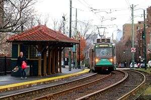 Outbound train at Coolidge Corner in February 2017 | |||||||||||
| Location |
Beacon Street at Harvard Street Brookline, Massachusetts | ||||||||||
| Coordinates | 42°20′32″N 71°07′15″W / 42.342226°N 71.120888°WCoordinates: 42°20′32″N 71°07′15″W / 42.342226°N 71.120888°W | ||||||||||
| Owned by | MBTA | ||||||||||
| Line(s) | |||||||||||
| Platforms | 2 side platforms | ||||||||||
| Tracks | 2 | ||||||||||
| Connections |
| ||||||||||
| Construction | |||||||||||
| Bicycle facilities | 20 spaces | ||||||||||
| Disabled access | Yes | ||||||||||
| History | |||||||||||
| Rebuilt | 2001 | ||||||||||
| Traffic | |||||||||||
| Passengers (2011) | 3,440 (weekday average boardings)[1] | ||||||||||
| Services | |||||||||||
| |||||||||||
Coolidge Corner is a light rail stop on the MBTA Green Line "C" branch, located at the intersection of Beacon Street and Harvard Street in the Coolidge Corner neighborhood of Brookline, Massachusetts. With 3,440 daily boardings by a 2011 count, it had more than twice the ridership of any other surface station on the branch.[1]
Coolidge Corner station is fully handicapped accessible after renovations completed in 2001.[2]
Station layout
| G Street/ Platform level |
Side platform, doors will open on the right | |
| Outbound | ← "C" Branch toward Cleveland Circle (Summit Avenue) | |
| Inbound | → "C" Branch toward North Station (St. Paul Street) → | |
| Side platform, doors will open on the right | ||
Bus connections
Coolidge Corner is served by a single MBTA Bus route, running on Harvard Street, but it is one of the most heavily used bus routes in the entire system.[3]
References
- 1 2 "Ridership and Service Statistics" (PDF) (14th ed.). Massachusetts Bay Transportation Authority. 2014.
- ↑ Rivera, Lydia (12 July 2001). "The MBTA Continues Accessibility Program At Coolidge Corner Station". MBTA Press Releases. Massachusetts Bay Transportation Authority. Archived from the original on 30 October 2001.
- ↑ "Coolidge Corner Station Neighborhood Map" (PDF). Massachusetts Bay Transportation Authority. April 2012. Retrieved 2 April 2016.
External links
![]()
This article is issued from
Wikipedia.
The text is licensed under Creative Commons - Attribution - Sharealike.
Additional terms may apply for the media files.