Goat Hill (Larimer County, Colorado)
| Goat Hill | |
|---|---|
| Bellvue Dome | |
.JPG) The dome as seen from the north northwest. | |
| Highest point | |
| Elevation | 1,708 m (5,604 ft) [1] |
| Coordinates | 40°38′33″N 105°10′12″W / 40.64250°N 105.17000°WCoordinates: 40°38′33″N 105°10′12″W / 40.64250°N 105.17000°W [1] |
| Geography | |
 Goat Hill Location in Colordo. | |
| Location | Larimer County, Colorado |
| Parent range | Front Range |
| Topo map |
USGS Laporte |
Goat Hill—also called Bellvue Dome—is a dome in Larimer County, Colorado near Bellvue.
The dome has a gradual slope on its east side, but its west side is an almost-vertical cliff that hangs over the Cache la Poudre River that passes directly below. The mountain was formed as sedimentary rock was uplifted and folded during the Laramide orogeny.[2]
Access
The mountain itself is on property owned by the Bureau of Land Management, but it's surrounded by private land, so access is difficult or impossible without permission from the adjacent property owners.[3]
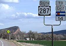
Goat Hill is prominently seen by motorists driving south on Highway 287. One can see the mountain in profile, with the slope on the left and the cliff on the right, before the highway turns east towards Fort Collins.
References
- 1 2 "Goat Hill". Geographic Names Information System. United States Geological Survey.
- ↑ "Bellvue Dome Earthcache". Geocaching. Retrieved 2017-09-02.
Locally know [sic] as Goat Hill, the geologic structure that dominates this landscape is a dome. Bellvue Dome, was formed by the bending of the sedimentary rocks layer underneath due to the same tectonic forces that uplifted the Rocky Mountains. A combination of the river’s erosive action and the nature of the fold gives the dome its actual appearance.
- ↑ Roe, Josiah. "Hike the Bellvue Dome". The Outbound Collective. Retrieved 2017-09-02.