Goat Canyon (Tijuana River Valley)
| Goat Canyon | |
|---|---|
| Canon de los Laureles[1] | |
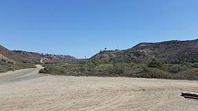 Looking south-southeast within Goat Canyon | |
 Goat Canyon Extreme southwest corner of the United States | |
| Location | Tijuana River Watershed[1] |
| Area | 4.6 sq mi (12 km2)[2] |
| Geography | |
| Bounded by |
Spooner's Mesa[3] Bunker Hill[3] |
| Coordinates | 32°32′12″N 117°05′58″W / 32.5367°N 117.0994°WCoordinates: 32°32′12″N 117°05′58″W / 32.5367°N 117.0994°W |
| Population centers |
Playas de Tijuana Tijuana River Valley, San Diego |
| Traversed by |
Mexico-United States barrier[4] Mexican Federal Highway 1D[5] |
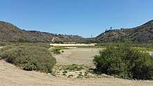
Goat Canyon (Spanish, el cañón de Los Laureles)[6] also known as Canon de los Laureles, is a canyon which begins in Tijuana and ends just north of the Mexico–United States border. The canyon is formed by Goat Canyon Creek,[7] which receives water and other runoff from areas south of the border.[1] The majority of the canyon and its watershed exists within Baja California.[8]
The canyon originated during the Quaternary period;[9] it is bordered by Bunker Hill to its west and Spooner's Mesa to its east.[3] The canyon is partially marshland and supports numerous sensitive and endangered species.[10][11]
Human activity in, and around, the canyon dates back to the prehistoric era.[12] The canyon was part of the route used by the Portolá expedition to San Diego Bay;[13] it was then part of the Missionary Road, which was abandoned in the late 19th century.[14]
Farms existed in and around Goat Canyon until government activity controlled the canyon.[15] South of the Tijuana-Ensenada scenic highway development began in the late 20th century;[5] due to this and into the 21st century, sewage has flowed northward.[16]
Geography
Rocks which form the canyon walls are relatively young, being no older than 10,000 years old within the Quaternary period.[9] The west wall of the canyon is about 5,000 m (16,000 ft) from the ocean.[17] The east wall of the canyon is made up of the slope that leads to Spooner's Mesa;[18] the mesa was named after a couple who had a homestead atop the mesa.[19]
Flora and fauna
Numerous sensitive and endangered species inhabit Goat Canyon, to include shrubs of the Southern willow, mule fat, Maritime succulent scrub varieties, and wildlife including least Bell's vireos, Belding's Savannah sparrow, and California gnatcatcher.[9] Within the northern portion of Goat Canyon is an environment categorized as southern coastal salt marsh, which supports some of the sensitive and endangered species previously listed.[10]
History
The earliest human activity in the canyon was a prehistoric campsite with a shell midden.[20][21] In the area surrounding the canyon, evidence had been found of human activity relating to the San Dieguito and La Jollan prehistoric cultures.[15][22] Within the canyon, there also existed a San Dieguito era quarry.[23] In 1769, the Portolá expedition's Portolá overland group, with whom Junípero Serra joined, came through Goat Canyon on their way to San Diego Bay.[13] In the 1770s, Spaniards recorded that at the mouth of the canyon there was a Native American village, they named it "Milejo".[15][24][25] In 1775, Kumeyaay living in the Tijuana River Valley, which Goat Canyon is in its southwestern portion, attacked Mission San Diego de Alcalá, which Serra had helped found several years prior;[13] at the attack, Friar Luis Jayme was martyred.[15][26] During the time when the canyon was part of Alta California, the canyon was part of Rancho Tía Juana in 1829.[15] By 1833, the canyon was part of Rancho Melijo.[27]
Sometime after the Mexican–American War the land from Imperial Beach to Monument Mesa was owned by Elisha Babcock, who went on to develop Coronado; it then passed to one of the owners of the Agua Caliente Casino and Hotel, James Crafton around the Great Depression.[28] Prior to 1872, the original El Camino Real alignment ran north from Goat Canyon.[14] In the late 1880s, with the completion of the National City and Otay Railway between San Diego and Tijuana, a city was planned for the area north of the westernmost border monument which never came to fruition.[24][29]
In the early 20th Century, a homestead was formed consisting of a house and a farm; the homestead was occupied until the 1980s when it was condemned by the city of San Diego.[30] The homestead was dairy farm owned by Harley E. Knox, who for a time was mayor of San Diego;[28][31] it remained in the ownership of the Knox Family until at least 1981 but was out of their control due to government control beginning in 1970.[32] While the early 20th Century structures are no longer present, excavation found that the area of the homestead was previously a site of a prehistoric camp.[30] The camp shows evidence that local material had been processed into tools, as indicated by two alluvial deposits;[33] it was recommended in 2001 that this site be placed on the National Register of Historic Places.[34][35]
In addition to the homestead, there was also a pig farm, which was run by a Mexican family in the 1940s; the father of the family died during the construction of a well at the farm, and the ruins of the home at the farm still existed up until 2001.[36]
United States government activity
United States military activity around the area of Goat Canyon began to the west, with the surveying of a border marker, then began to travel east to delineate the border established in the Treaty of Guadalupe Hidalgo, which ran through the canyon.[37] This included placing a marker atop the hill west of Goat Canyon, boundary monument #257.[38] While there was a temporary United States Army outpost established during the Mexican Revolution, a more significant Navy presence was established with the creation of an airfield in the late 1920s.[37][39][40] In 1943 near the canyon, on the south side of the base, 35 buildings were built near Monument Road to support military operations at the airfield, including a trap house.[41]
In 1935, a survey of preexisting defenses lead to planning for expansion of coastal defenses for San Diego Bay.[42] In 1942, during World War 2, the United States Army "base end stations" were constructed on the hill west of the canyon;[42][43] the group of bunkers was named "Mexican Border Fire Control Station."[43][44][45] In 1943, a fire control radar was installed at the Fire Control Station.[42][46] The bunkers assisted targeting for Coastal Artillery batteries at Fort Rosecrans and Fort Emory.[43] In 1951, a plane crashed at the airfield, leading to its end as an aerial gunnery range.[47] After World War 2, in 1953, the United States Army transferred the Fire Control Station to the United States Navy, which placed it under control of the airfield;[43] the border field airfield was itself under Naval Auxiliary Air Station Imperial Beach.[42]
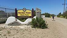
In 1961, Border Field along with Goat Canyon was given to Navy Electronics Laboratory.[39] Other users of the area were the California National Guard who launched pilot-less drones in the decade prior, and the Imperial Beach Police Department who had a shooting range on the land.[48] At the time, a renewed effort to build a city in the area was made, these plans never materialized.[24] By 1971, the United States Navy transferred the site to the State of California, which opened Border Field State Park.[39][43] Sometime between 1981 and 1998, a border road used by the United States Border Patrol was constructed on the eastern wall of the canyon leading up to Spooner's Mesa; the construction destroyed a paleolithic site and adobe ruins.[49] Since 2009, the bunkers atop Bunker Hill are no longer publicly accessible;[44] this is due to the Federal Government reacquiring land for construction of the Mexico–United States barrier.[4]
In late April 2018, some members of the Central American migrant caravan were contacted by American authorities while illegally entering the United States in the canyon.[50] They were prosecuted, while three people from India, who were also contacted by American authorities around that time were processed for asylum.[51]
Canon de los Laureles development and impact
In 1960, construction of Tijuana Ensenada highway occurred just south of the Mexico-United States Border, through the canyon.[5] Following the construction of the highway, as well as a concrete channel in the canyon on the Mexican side, led to people moving into Canon de los Laureles in an unplanned manner.[5] In 1981, Goat Canyon was not a significant contributor to the 300,000 US gal (1,100 kL) of sewage flowing into the Tijuana River.[52] In 1983, due to sewage spills which originated from Goat Canyon, it was proposed that a pump be installed.[53] Once installed the pump, which handles flow from Smuggler's Gulch and Goat Canyon, can pump as much as 7,000,000 US gal (26,000 kL) a day.[54] In 1990, 110,000 US gal (420 kL) a day of sewage originated from the canyon and flowed into the Tijuana River.[55] By 1998, the canyon had areas of low-income housing, which was prone to damage during seasonal rains, which caused flash floods.[8][56] In 2001, a pipeline was located in Goat Canyon, meant to send sewage from the canyon to the International Boundary Wastewater Treatment Plant.[57][58] Treated water from the International Boundary Wastewater Treatment Plant, is pumped to a location over 18,000 ft (5,500 m) offshore through a pipe which passes over 100 ft (30 m) below the northern mouth of Goat Canyon.[57]
A sediment basin was constructed at the mouth of the canyon in 2005, due to significant amounts of material originating from south of the border that ended up in the Tijuana River Estuary, leading to loss of habitat.[59] The yearly cost of emptying the sediment basin is between a quarter to over a million dollars a year.[60] By 2009, over 65,000 people lived in the Mexican portion of the canyon, part of which is Colonia San Bernardo.[61] In 2014, the population in the Mexican portion of the canyon grew to 85,000, with the housing described as a "shanty town".[62] Even with the pipeline and later upgrades to the International Boundary Wastewater Treatment Plant, there is sewage in Goat Canyon.[16]
In 2010, with the construction of the Mexico–United States barrier, diverts were constructed to assist with the flow of water through the canyon.[63] In 2012, labor-intensive trash nets were used to catch debris, so it would not embed in the sediment.[60] Also in 2012, a $50,000 program was conducted to reduce erosion on the Mexican side of the canyon.[64] By 2014, environmentalists were able to create a recognized "watershed council" to give the area political representation in order to increase infrastructure growth within the Mexican portion of the canyon.[62]
In March 2017, black water came through from the Mexican side of the canyon and flowed into the sediment basins, the previous month the water that came through was red.[65] Wastewater from upstream of the canyon was reported by United States Border Patrol agents in May 2017, leading to complaints about health concerns which joined bipartisan concerns by others such as Darrell Issa and Juan Vargas about wastewater from Mexico impacting the Tijuana River.[63] In 2017, the American budget for border wastewater projects was zeroed out.[66] In October 2017, the amount of fecal indicator bacteria was found to be in above average concentrations.[67] In February 2018, more than 50,000 gallons of waste, including sewage, came through the Goat Canyon pump station, spilling into the Tijuana River.[68] In May 2018, the Surfrider Foundation released a report regarding the toxicity of the Tijuana River, and Goat Canyon in particular, with E. coli levels significantly greater than the standard levels.[69]
See also
| Wikimedia Commons has media related to Goat Canyon. |
References
- 1 2 3 Southwest Wetlands Interpretive Association 2001, p. 5-1.
- ↑ Southwest Wetlands Interpretive Association 2001, p. 5-123.
- 1 2 3 Southwest Wetlands Interpretive Association 2001, p. 5-273.
- 1 2 Graham, Marty (29 May 2014). "Land-grabbers pay up". San Diego Reader. Retrieved 13 April 2018.
- 1 2 3 4 Southwest Wetlands Interpretive Association 2001, p. 5-29.
- ↑ Atlas de la Cuenca Del Río Tijuana (in Spanish). SCERP and IRSC publications. 2005. p. 35. ISBN 978-0-925613-44-8.
- ↑ Southwest Wetlands Interpretive Association 2001, p. 5-2.
- 1 2 Suzanne Michel (2003). The U.S.-Mexican Border Environment: Binational Water Management Planning. SCERP and IRSC publications. p. 315. ISBN 978-0-925613-40-0.
- 1 2 3 Southwest Wetlands Interpretive Association 2001, p. 5-13.
- 1 2 Southwest Wetlands Interpretive Association 2001, p. 5-14.
- ↑ Ponitius 2003, p. 3-30.
- ↑ Ponitius 2003, pp. 3-54 - 3-58.
- 1 2 3 Barbara Zaragoza (23 June 2014). San Ysidro and The Tijuana River Valley. Arcadia Publishing Incorporated. pp. 9–. ISBN 978-1-4396-4592-5.
- 1 2 "Historic Sites of Imperial Beach". South Bay Historical Society Bulletin. City of Chula Vista (12). April 2016. Retrieved 14 April 2018.
- 1 2 3 4 5 D'Elgin, Tershia; Krautheim, Veronica; Leonard, Betsy; Ahmad, Marya; Warner-Lara, Lorena; Tipton, Anne Marie. "3. History" (PDF). High School Teacher's Guid. Tijuana River National Estuarine Research Reserve. Retrieved 14 April 2018.
- 1 2 Dedina, Serge (7 February 2007). "The Other Border Sewage Contractor". Voice of San Diego. Retrieved 7 April 2018.
Abcarian, Robin (13 March 2018). "If Trump really wants to fix our border problems, he should visit the sewage pools, not his silly walls". Los Angeles Times. Retrieved 7 April 2018. - ↑ Environmental Impact Statement For The Completion of the 14-Mile Border Infrastructure System San Diego, California. Immigration and Naturalization Service. January 2002. p. 23.
- ↑ Fisher, Robert; Case, Ted (February 2000). Final Report on Herpetofauna Monitoring In The Tijuana Estuary National Estuarine Research Reserve (PDF) (Report). Tijuana Estuary National Estuarine Research Reserve. p. 8. Retrieved 7 April 2018.
- ↑ Barker, Lucy D. (20 February 2013). "More trails for Tijuana River Valley, but none to the mesas". San Diego Reader. Retrieved 7 April 2018.
- ↑ Southwest Wetlands Interpretive Association 2001, p. 5-205.
- ↑ Norby 2001, p. ixvii.
- ↑ Ponitius 2003, p. 3-57.
- ↑ Ponitius 2003, pp. 3-54 - 3-55.
- 1 2 3 Roper, Tessa; Phillips, Clay; Brubaker, Don; Crooks, Jeff; Tiption, Anne Marie; Goodrich, Kristen; Romo, Oscar; Peregrin, Chris; Abbott, Greg (September 2010). Comprehensive Management Plan (PDF) (Report). Tijuana River National Estuarine Research Reserve. p. 29. Retrieved 8 April 2018.
- ↑ AECOM; Apple, Rebecca; Jordan-Connor, Stacey; Bowden-Renna, Cheryl; Jow, Stephanie; York, Andrew (January 2015). Prehistoric Cultural Resources (PDF) (Report). City of San Diego. Community Plan Update for the Community of San Ysidro. Retrieved 15 April 2018.
- ↑ Weber, Francis J. (Winter 1976). "The Death of Fray Luis Jayme Two Hundredth Anniversary". San Diego Historical Society Quarterly. 22 (1). Retrieved 14 April 2018.
- ↑ Schoenherr, Steve (16 July 2017). "Otay Ranch". SunnyCV.com. South Bay Historical Society. Retrieved 14 April 2018.
Chas. H. Poole (10 November 1954). Plan of the Rancho of Melijo (Map). 1:31,680. United States District Court (California: Southern District). Retrieved 15 April 2018. - 1 2 Schoenherr, Steven (July 2015). "The Tijuana River Valley Historic Sites". South Bay Historical Society Bulletin (9): 1–18. Retrieved 14 April 2014.
- ↑ Zaragoza, Barbara (April 2015). "The San Diego-Tijuana Boundary Monuments". South Bay Historical Society Bulletin. City of Chula Vista (8). Retrieved 14 April 2018.
Flanigan, Kathleen; Coons, Bruce (2007). "National City & Otay Railroad Depot". Sohosandiego.org. Save Our Heritage Organization. Retrieved 14 April 2018.
"Railroads of the South Bay". South Bay Historical Society Bulletin (4): 1–4. July 2014. Retrieved 14 April 2018. - 1 2 Southwest Wetlands Interpretive Association 2001, p. 5-209.
- ↑ Norby 2001, p. cxix.
- ↑ MacFarland, James W. (August 1981). Proposed Estuarine Sanctuary Grant Award to the State of California for a Tijuana River National Estuarine Sanctuary (Report). Government Printing Office. Retrieved 14 April 2018.
- ↑ Southwest Wetlands Interpretive Association 2001, p. 5-210.
- ↑ Southwest Wetlands Interpretive Association 2001, p. 5-347.
- ↑ Norby 2001, p. cxcix.
- ↑ Norby 2001, pp. ixxxiii - xcix.
- 1 2 Schoenherr, Steve (18 April 2015). "Border Field State Park". SunnyCV.com. South Bay Historical Society. Retrieved 8 April 2018.
- ↑ "The Military Bunkers Of The Tijuana River Valley". South Bay Compass. Retrieved 13 April 2013.
- 1 2 3 Barbara Zaragoza (2014). San Ysidro and The Tijuana River Valley. Arcadia Publishing. p. 81. ISBN 978-1-4671-3188-9.
- ↑ The Canyoneers (1 June 2016). "No bay at Border Field State Park for about 7000 years". San Diego Reader. Retrieved 8 April 2018.
- ↑ Norby 2001, pp. xcix - cxvii.
- 1 2 3 4 Schoenherr, Steve (28 March 2015). "Military Bases in the South Bay". SunnyCV.com. South Bay Historical Society. Retrieved 8 April 2018.
- 1 2 3 4 5 "Border Field Naval Reservation". California State Military Museums. California Military Department. 8 February 2016. Retrieved 8 April 2018.
- 1 2 Berestein, Leslie (25 August 2009). "Border bunker battle". San Diego Union-Tribune. Retrieved 8 April 2018.
- ↑ "DoD Defesne Site Inventory as of end of FY13". Executive Services Directorate. United States Department of Defense. 2013. Retrieved 8 April 2018.
- ↑ National Archives. "War Period History Harbor Defenses of San Diego" (PDF). California State Military Museums. California Military Department. Retrieved 8 April 2018.
- ↑ Norby 2001, p. ci.
- ↑ United States Army Corps of Engineers - Los Angeles District (Fall 2013). Border Field State Park (PDF) (Report). United States Army. Retrieved 13 April 2018.
- ↑ Ponitius 2003, p. 3-54.
- ↑ Li, David K. (30 April 2018). "11 members of migrant 'caravan' arrested at US border". New York Post. Retrieved 6 June 2018.
- ↑ Moran, Greg (23 May 2018). "Judge indicates charges against Central Americans said to be caravan members will stand". San Diego Union-Tribune. Retrieved 6 June 2018.
- ↑ J. F. Friedkin; John J. Vandertulip (March 1981). Proposed Recommendations for Solution of the Border Sanitation Problem at Tijuana, B.C.N. & San Diego, Cal. International Boundary & Water Commission. p. 10.
- ↑ "South Bay Officials Studdy Sewage Plant Proosal". Star News. Chula Vista, California. 24 November 1983. Retrieved 8 April 2018.
- ↑ "Background of the International Border Sanitation Problem and Solutions". International Boundary and Water Commission. Retrieved 7 April 2018.
- ↑ Parsons; United States Environmental Protection Agency (July 2005). Supplemental Environmental Impact Statement. United States Section, International Boundary And Water Commission. pp. 11–38.
- ↑ San Diego State University; El Colegio de la Frontera Norte; Tijuana River National Estuarine Research Reserve; National Ocean Service; International Programs Office; Environmental Systems Research Institute, Inc. (June 2000). Demonstration Project (Report). Federal Geographic Data Committee.
- 1 2 Southwest Wetlands Interpretive Association 2001, p. 5-19.
- ↑ History of San Diego & Tijuana Sewage Systems (PDF) (Report). University of San Diego. p. 7. Retrieved 7 April 2018.
- ↑ Tijuana Estuary Sediment Study (PDF) (Report). California Division of Boating and Waterways. 25 March 2008. Retrieved 6 April 2018.
- 1 2 Tijuana River Valley Recovery Team; Gibson, David (January 2012). "Recovery Strategy: Living with the Water" (PDF). California Water Boards. States of California. Retrieved 7 April 2018.
- ↑ Shannon Bradley; Laura Casteneda (2 November 2009). Los Laureles Canyon: Research in Action (youtube video). University of California, San Diego. Retrieved 8 April 2018.
- 1 2 McGuirk, Justin (2 July 2014). "Here's What It's Like To Live In Tijuana — The Busiest Land Crossing In The World". Business Insider. United States. The Guardian. Retrieved 8 April 2018.
- 1 2 Smith, Joshua Emerson (26 May 2017). "Border Patrol agents said Tijuana sewage problem worse now than in previous decades". San Diego Union Tribune. Retrieved 7 April 2018.
- ↑ "Erosion Control at the Canon de los Laureles watershed with Permeable Pavement Technology". Projects. Border Environment Cooperation Commission. 2012. Retrieved 7 April 2018.
- ↑ Graham, Marty (2 March 2017). "Goat Canyon spills...black tea?". San Diego Reader. Retrieved 7 April 2018.
- ↑ Anderson, Erik (2 June 2017). "Tijuana's Sewage System Needs Major Upgrades". KPBS. San Diego. Retrieved 7 April 2018.
- ↑ "Contamination forces volunteer group out of Goat Canyon trash pickup". KFMB-TV. San Diego. 14 October 2017. Retrieved 7 April 2018.
- ↑ Nunez, Jose; Pruitt, scott (14 May 2018). 60-Day Notice of Intent to Sue for Violations of the Federal Water Pollution Control Act by the United States Section of the International Boundary and Water Commission; CW760862:cclemente (PDF) (Report). San Diego Regional Water Quality Control Board. Retrieved 6 June 2018 – via Attorney General of the State of California.
- ↑ Williams, Dana; Hammell, Adam (25 May 2018). The Impact of the Toxic Water Crisis on US Border Patrol (Report). Surfrider Foundation. Retrieved 6 June 2018.
Further reading
- Southwest Wetlands Interpretive Association; Tierra Environmental Services, Inc. (2001). Goat Canyon Enhancement Project: Environmental Impact Statement. National Oceanic and Atmospheric Administration.
- Norby, Chris; Southwest Wetlands Interpretive Association; Tierra Environmental Service, Inc. (21 December 2001). Final Environmental Impact Statement And Environmental Impact Report For The Goat Canyon Enhancement Project. Appendices B (Biological) And C (Cultural). National Oceanographic And Atmospheric Administration.
- Geraldine Ponitius; Kevin Feenery; Elizabeth Gaffin; Kevin Jackson; Joe Lamphaer; Louis Cross; Mike Hance; Todd Birdsong; Calvin Davis (July 2003). Environmental Impact Statement for the Completion of the 14-Mile Border Infrastructure System (Report). Joe Granata, CW4 Carl Anderson, Todd Smith, Stephen Brooks, Charles McGregor, Patience Patterson, Bobby Shelton, Eric Venwers, Donna Bankston, Chris Ingram, Suna Knaus, Kate Koskie Roussel, John Lindermuth, Josh McEnary, Howard Nass, Sharon Newman, Mike Schulze, Brady Turk, Eric Worsham, Mark Pilwallis, Eric Neal, Kofi Anumah, Chad Karam, Marianne Aydil, Mike Howard, Steve Lacy. United States Department of Homeland Security.
| Counties and Municipalities |  | |
|---|---|---|
| Major cities | ||
| Cities 100k - 250k | ||
| Cities and towns 20k - 99k | ||
| Cities and towns 10k-19k | ||
| Bodies of water | ||
| Sub-regions | ||
| ||