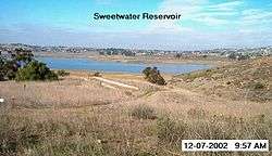
Sweetwater Reservoir
| Sweetwater Reservoir | |
|---|---|
 | |
| Location | San Diego County, California[1] |
| Coordinates | 32°41′49″N 116°59′14″W / 32.69694°N 116.98722°WCoordinates: 32°41′49″N 116°59′14″W / 32.69694°N 116.98722°W[2] |
| Type | Reservoir |
| Primary inflows | Sweetwater River |
| Primary outflows | Sweetwater River[1] |
| Catchment area | 182 square miles (470 km2)[1] |
| Basin countries | United States |
| Built | April 7, 1888 |
| Max. length | 2 miles (3.2 km) |
| Max. width | 0.75 miles (1.21 km) |
| Surface area | 936 acres (379 ha)[1] |
| Max. depth | 108 feet (33 m) |
| Water volume | 27,689 acre feet (34,154,000 m3)[1] |
| Frozen | Never |
| Islands | none |
| Settlements | La Presa |
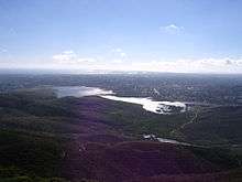
Sweetwater Reservoir as seen from San Miguel Mountain in 2006
Sweetwater Reservoir is a 960-acre (390 ha) artificial lake in San Diego County, California, formed by the Sweetwater Dam on the Sweetwater River. Construction of the dam was completed in 1888.
Environment
The area surrounding the reservoir is home to several species, including least Bell's vireo and the California gnatcatcher. It lies near the census-designated places of Bonita, La Presa and Spring Valley. The drainage basin it forms along with Loveland Reservoir covers 230 square miles (600 km2).
See also
References
- 1 2 3 4 5 "Dams Within the Jurisdiction of the State of California" (PDF). California Department of Water Resources. Retrieved 2014-08-25.
- ↑ "Sweetwater Reservoir". Geographic Names Information System. United States Geological Survey. 1981-01-19. Retrieved 2011-01-20.
This article is issued from
Wikipedia.
The text is licensed under Creative Commons - Attribution - Sharealike.
Additional terms may apply for the media files.