Tijuana
| Tijuana | |
|---|---|
| City | |
| City of Tijuana | |
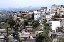
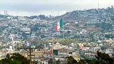
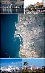
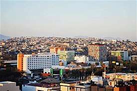 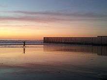 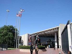 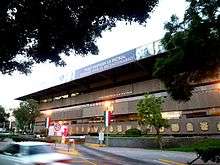   From up to down and left to right: Zona Río district panoramic view, Playas de Tijuana, Otay Mesa Port of Entry, Tijuana City´s Hall, Tijuana Cultural Center y Tijuana´s Culture House A view of Tijuana | |
|
Nickname(s): T.J. Gateway to Mexico A Heart Between Two Seas | |
| Motto(s): Aquí empieza la patria (The fatherland begins here) | |
|
Tijuana Location of Tijuana within Mexico | |
| Coordinates: 32°31′30″N 117°02′0″W / 32.52500°N 117.03333°W | |
| Country |
|
| State |
|
| Municipality | Tijuana |
| Founded | July 11, 1889 |
| Government | |
| • Type | Ayuntamiento |
| • Municipal President | Juan Manuel Gastélum (PAN) |
| Area | |
| • City | 637 km2 (246 sq mi) |
| • Metro | 1,392.5 km2 (537.9 sq mi) |
| Elevation | 20 m (65 ft) |
| Population (2015) | |
| • City | 1,641,570 [1] |
| • Estimate (2018) | 1,802,004 |
| • Metro | 1,840,710 [1] |
| [2] | |
| Demonym(s) | Tijuanan, Tijuanense[3] |
| Time zone | UTC−8 (PST) |
| • Summer (DST) | UTC−7 (PDT) |
| Postal code | 22000-22699 |
| Area code(s) | + 52 664 |
| Website | http://www.tijuana.gob.mx |
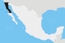
Tijuana (/tiːˈhwɑːnə/ tee-WHAH-nə; Spanish: [tiˈxwana]) is the largest city in the Mexican state of Baja California and on the Baja California Peninsula. It is part of the San Diego–Tijuana international transborder agglomeration. As one of the largest and fastest growing cities of Mexico,[4] Tijuana exerts a strong influence on local economics, education, culture, art, and politics. As the city has become a leading center in the country, so has the surrounding metropolitan area, a major industrial and paramount metropolis in northwestern Mexico. Currently one of the fastest growing metropolitan areas in Mexico,[4] Tijuana maintains global city status.[5] As of 2015, the city of Tijuana had a population of 1,641,570.[1]
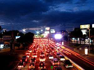
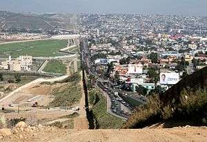
Tijuana is located on the Gold Coast of Baja California, and is the municipal seat and the cultural and commercial center of Tijuana Municipality. Tijuana covers 70% of the municipality but contains over 80% of its population. A dominant manufacturing center of the North American continent, the city maintains facilities of many multinational conglomerate companies. In the early 21st century, Tijuana became the medical-device manufacturing capital of North America. Tijuana is also a growing cultural center and has been recognized as an important new cultural mecca.[6] The city is the most visited border city in the globe; sharing a border of about 24 km (15 mi) with its sister city San Diego. More than fifty million people cross the border between these two cities every year. This metropolitan crossing makes the San Ysidro Port of Entry the busiest land-border crossing in the world.[7] It is estimated that the two border crossing stations between the cities proper of San Diego and Tijuana account for 300,000 daily border crossings alone.
Tijuana is the 45th largest city in the Americas and is the westernmost city in Mexico. According to the 2015 census, the Tijuana metropolitan area was the fifth-largest in Mexico, with a population of 1,840,710,[1] but rankings vary, the city (locality) itself was 6th largest and the municipality (administrative) 3rd largest nationally. The international metropolitan region was estimated to be about 5,158,459 in 2016,[8] making it the third largest metropolitan area in the former Californias region, 19th largest metropolitan area in the Americas,[9] and the largest bi-national conurbation that is shared between US and Mexico. Tijuana is becoming more suburbanized like San Diego.
Tijuana traces its modern history to the arrival of Spanish explorers in the 16th century who were mapping the coast of the Californias. As the American conquest of northern Mexico ended with the Treaty of Guadalupe Hidalgo, Tijuana's new international position on the border gave rise to a new economic and political structure. The city was founded on July 11, 1889 as urban development began. Often known by its supposed initials, T.J., and nicknamed Gateway to Mexico, the city has historically served as a tourist center dating back to the 1880s.
Name
Etymology
The first historic mission documents — primarily baptism, marriage, and death records — name the city with the names as 'La Tía Juana', 'Tiguana', 'Tiuana', 'Teguana', 'Tiwana', 'Tijuan', 'Ticuan', and the present day name, 'Tijuana'. The commonly accepted theory among historians is that the modern-day Tijuana is derived from a word belonging to the Kumeyaay language – the original aboriginal inhabitants of the San Diego-Tijuana region. Tijuana derives from the Kumeyaay word Tiwan, meaning by-the-sea. Common in regional folklore, a myth exists purporting that the name is a conjunction of Tía Juana, the Spanish-language version of Aunt Jane. Tía Juana would provide food and a resting place to travelers on their journeys. The story has become a popular myth with residents of the city and has particular resonance among those who like to imagine the city as a place of hospitality.
Modern
In Spanish, the name is pronounced /tiˈxwana/ – with three syllables, and a velar fricative as represented by the sound written as j. In English, the name is usually pronounced as having four syllables: /tiːəˈwɑːnə/ ("Tia-wana"), a pronunciation that was common amongst California English speakers in the present; less commonly, it is pronounced truer to Spanish, with three /tiːˈwɑːnə/. In California, and particularly in Southern California, it is often referred to as T.J. Baja Californians have adopted this pronunciation as Tiyei. In Spanish the demonym for someone from Tijuana is Tijuanense, while in English the demonym is Tijuanan. A very common slang term used for a person from Tijuana is Tijuanero.
The nickname Tijuas is increasingly popular among residents and visitors alike. Due to a recent increase in violence in the city, a new term is developing. The phrase Yo Tijuaneo, ¿y tú? translates to I Tijuanate, and you?. This term comes from a new popular local verb Tijuanear meaning to Tijuana, describing the cosmopolitan aspects of living in the city and frequently crossing the border.
History
| Early explorers | |
|---|---|
 |
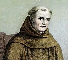 |
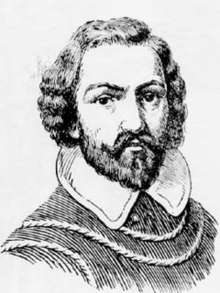
| Juan Rodríguez Cabrillo. | Fray Junípero Serra. |
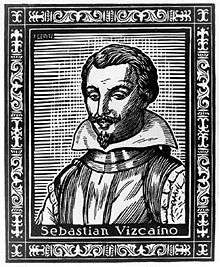
The land was originally inhabited by the Kumeyaay, a tribe of Yuman-speaking hunter-gatherers. Europeans arrived in 1542, when the explorer Juan Rodríguez Cabrillo toured the coastline of the area, which was later mapped in 1602 by Sebastián Vizcaíno. In 1769, Juan Crespí documented more detailed information about the area that would be called the Valley of Tijuana. Junípero Serra founded the first mission of Alta California in nearby San Diego.
Further settlement took place near the end of the mission era when José María de Echeandía, governor of the Baja California and Alta California, awarded a large land grant to Santiago Argüello in 1829. This large cattle ranch, Rancho Tía Juana ("Aunt Jane Ranch"), covered 100 km2 (40 sq mi). In 1848, as a result of the Mexican–American War with the United States, Mexico lost all of Alta California. The majority of the 1,000 Hispanic families living in Alta California stayed there, though some moved south to remain inside Mexico. Because of this Tijuana gained a different purpose on the international border. The area had been populated by ranchers, but Tijuana developed a new social economic structure. These were farming and livestock grazing, plus as a transit area for prospectors.[10]
Urban settlement began in 1889, when descendants of Santiago Argüello and Augustín Olvera entered an agreement to begin developing the city of Tijuana. The date of the agreement, July 11, 1889, is recognized as the founding of the city.[11] Tijuana saw its future in tourism from the beginning. From the late 19th century to the first few decades of the 20th century, the city attracted large numbers of Californians coming for trade and entertainment. The California land boom of the 1880s led to the first big wave of tourists, who were called "excursionists" and came looking for echoes of the famous novel "Ramona" by Helen Hunt Jackson.
In 1911, during the Mexican Revolution, revolutionaries claiming loyalty to Ricardo Flores Magón took over the city for shortly over a month. Federal troops then arrived. Assisted by the "defensores de Tijuana", they routed the revolutionaries, who fled north and were promptly arrested by the United States Army.
The Panama-California Exposition of 1915 brought many visitors to the nearby California city of San Diego. Tijuana attracted these tourists with a Feria Típica Mexicana – Typical Mexican Fair. This included curio shops, regional food, thermal baths, horse racing and boxing.
The first professional race track opened in January 1916, just south of the border gate. It was almost immediately destroyed by the great "Hatfield rainmaker" flood of 1916. Rebuilt in the general area, it ran horse races until the new Agua Caliente track opened in 1929, several miles south and across the river on higher ground.
Legal drinking and gambling attracted U.S nationals in the 1920s during Prohibition. The Avenida Revolución area became the city's tourist center, with casinos and the Hotel Caesar's, birthplace of the Caesar salad.
In 1925, the city attempted to shed its negative image of hedonism and lawlessness created by American mob empresarios by renaming itself Zaragosa, but its name soon reverted to Tijuana.
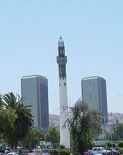
In 1928, the Agua Caliente Touristic Complex was opened, including hotel, spa, dog-track, private airport, golf course and gambling casino. A year later, the new Agua Caliente Racetrack joined the complex. During the eight years it operated, the Agua Caliente hotel, casino and spa achieved a near mythical status, with Hollywood stars and gangsters flying in and playing. Rita Hayworth was discovered there. Musical nightclub productions were broadcast over the radio. A singer known as "la Faraona" got shot in a love-triangle and gave birth to the myth of a beautiful lady ghost. Remnants of the Agua Caliente casino can be seen in the outdoor swimming pool and the "minarete" (actually a former incinerator chimney) nearby the southern end of Avenida Sanchez Taboada, on the grounds of what is now the Lazaro Cardenas educational complex.
In 1935, President Cárdenas decreed an end to gambling and casinos in Baja California, and the Agua Caliente complex faltered, then closed. In 1939, it was reopened as a junior high school (now, Preparatoria Lázaro Cárdenas). The buildings themselves were torn down in the 1970s and replaced by modern scholastic architecture.
With increased tourism and a large number of Mexican citizens relocating to Tijuana, the city's population grew from 21,971 to 65,364 between 1940 and 1950.
With the decline of nightlife and tourism in the 1950s, the city restructured its tourist industry, by promoting a more family-oriented scene. Tijuana developed a greater variety of attractions and activities to offer its visitors.
In 1994, PRI presidential candidate Luis Donaldo Colosio was assassinated in Tijuana while making an appearance in the plaza of Lomas Taurinas, a neighborhood nestled in a valley near Centro. The shooter was caught and imprisoned, but doubts remain about who the mastermind might have been.
In the new century, Tijuana has become an important city of commerce and migration for Mexico and US. In spite of the 9/11 on 2001 and the violence and crime wave from 2008-2011, the city has received a big number of tourists from US, China, Japan and the south of Mexico. Thanks to the realization of cultural and business festivals, the city has improved its image before the world, standing out as a competitive city for investment. Currently, the commercial and business sector is committed to the boom in the gastronomic industry, craft beer, entertainment and real estate, as well as medical tourism, to attract visitors and investors.
Geography

Tijuana is the western-most city in Mexico, and consequently in Latin America, and the 2nd largest city of northern Mexico. Located about 210 kilometers (130 mi) west of the state-capital, Mexicali, the city is bordered to the north by the cities of Imperial Beach, and the San Diego neighborhoods of San Ysidro and Otay Mesa, California. To the southwest of the city is Rosarito Beach, while to the south is unincorporated territory of Tijuana Municipality. The city is nestled among hills, canyons, and gullies. The central part of the city lies in a valley through which flows the channeled Tijuana River.
Housing development in the Tijuana Hills has led to eradication of many seasonal mountain streams. This lack of natural drainage makes places within the city vulnerable to landslides during the rainy season. The varied terrain of Tijuana gives the city elevation extremes that range from sea level to 790 metres (2,590 ft).
Tijuana is noted for its rough terrain, which includes many canyons, steep hills, and mesas. Among noted canyons in Tijuana are Canyon K and Canyon Johnson. Large Tijuana hills include Red Hill (Cerro Colorado) and Hill of the Bees (Cerro de las Abejas) in the eastern part of the city.
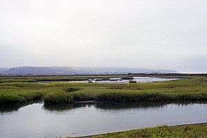
The city is located near the terminus of the Tijuana River and within the Tijuana River Basin. The Tijuana River is an intermittent river, 195 km (121 mi) long, on the Pacific coast of northern Baja California in Mexico and Southern California in the United States. It drains an arid area along the California–Baja California border, flowing through Mexico for most of its course and then crossing the border for the last 8 km (5 mi) of its course where it forms an estuary that empties into the ocean. The river's lower reaches harbor the last undeveloped coastal wetlands in San Diego County, and some of the last in Southern California, amidst a highly urbanized environment at the southern city limits of Imperial Beach.
As Downtown Tijuana was built at the bottom of the river valley, the district is subject to seasonal flooding created by drain-off from the Tijuana Hills. During this time, east-bound portions of the Via Rapida (east-west highway) may be blocked off by the Tijuana Police due to hazardous conditions.
Cityscape
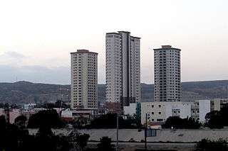
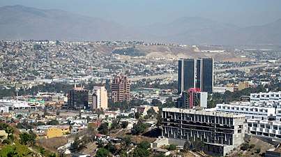
The city's skyscraper history is relatively recent.[13] Some of the first highrise building complexes constructed in the city were the twin towers of Grand Hotel Tijuana.[13] Tijuana experienced a building boom that was brought to a halt by the Great Recession. Among buildings that succumbed to the time period was the Trump Ocean Resort Baja Mexico that would have been located in Playas and reached 98 m (322 ft).[14] Currently the tallest building, and soon to be the largest complex in footage, New City Residential reaches 102 m (335 ft). Overall, the city maintains 33 completed structures with other proposed and under-construction skyscrapers.[13]
The Tijuana skyline is the fifth largest skyline in Mexico and is located in the Zona Rio and to a smaller extent, Playas de Tijuana. In the Zona Rio the buildings are concentrated on the Tijuana River, lined parallel to the river; and on the edges of the Tijuana Country Club. In Playas the high rises are currently focused on the coast. Recent construction on high rises has begun in the aforementioned areas, as buildings such as New City Residential and Grand Hotel Tijuana have been developed and taken prominent places in the skyline as the tallest buildings. From Tijuana's skyline the San Diego skyline can also be seen.
Boroughs and neighborhoods
The municipality of Tijuana is divided into eight administrative boroughs, or Delegaciones. The Tijuana metropolitan area occupies all of borough seats. The boroughs are in turn divided into colonias or ejidos. These boroughs offer administrative services such as urban planning, civil registry, inspection, verification, public works and community development and are served by a delegado.
- Centro — "Delegación Centro" includes the old downtown (Zona Centro), new business district (Zona Río), red light district (Zona Norte), and other adjacent neighborhoods ("zonas").[15] This is the historical midpoint of Tijuana; the municipal palace is located here as well as most of the tourist zones, such as Avenida Revolución and the business district. The Tijuana Cultural Center (CECUT for CEntro CUltural de Tijuana) is located here as well as the Plaza Río Tijuana, until recently the largest mall in the state, within the Zona Rio.
- Cerro Colorado — The Cerro Colorado ("Red Hill") is located here and it is surrounded by houses. Because of its height many of the area's antennae for radio and television stations are located on its peak.
- La Mesa — This is where the Morelos Park, the largest public park in the city, is located, as well as the Plaza Mundo Divertido, the new Macroplaza and the CETYS University.
- Otay Centenario — This borough was created in 2014 by merging Mesa de Otay and Centenario boroughs.[16] In this borough sits the Tijuana International Airport. The Tijuana campus of the Autonomous University of Baja California and the Technologico are also located here as well as many maquiladoras. This is the borough with the largest number of factories and maquiladoras. Its largest colony is Ciudad Industrial ("Industrial City"). Three of the city's most important streets, Boulevard Bellas Artes, Boulevard Industrial and Fed 2, are located here. This delegacion contains the Otay Mesa entry to the United States and the Friendship Park (Parque de la amistad).
- Playas de Tijuana[17] — This is the westernmost borough of the city bordered by the Pacific Ocean on the west and the United States border on the north. This is where the beaches of Tijuana are located (hence the name) and it is also one of the two exits to the south towards Rosarito and Ensenada.
- La Presa — literally "'the dam'", this is the largest borough in size and the Abelardo L. Rodríguez Dam is located within its limits, hence its name. The new Corredor Tijuana-Rosarito 2000 and the Tijuana-Tecate freeways run through it.
- San Antonio de los Buenos — This is mostly a residential area although it also has two industrial parks.
- Sanchez Taboada — Like the previous borough this is mostly a residential area, but within its borders are located many "maquiladoras" specially at Pacific Industrial Park.
Climate
Tijuana's climate is a semi-arid (Köppen climate classification BSh),[18] with about 231 mm (9.09 in) of annual precipitation, and generally mild to warm weather year-round. It has characteristics of the Mediterranean climate (Csa) found to the immediate north, with most of the annual precipitation falling in the winter, between the months of November and March.[19]
During the rainy season, November through March, storms originate from fronts entering off of the Pacific Ocean. January is the wettest month of the year for the city and during this time a periodic event, similar to June Gloom, is observed created by marine layer. January is the coolest month, during which temperatures average 13.6 °C (56.5 °F). In the city April signifies the end of winter and the start of Santa Ana winds – observed in Southern California as well. Though the daytime highs are generally around 20 °C (68 °F), heat waves can reach up to 33 °C (91 °F). The hottest months in the city, also the dry season, are August and September, during which temperatures average 22.0 °C (71.6 °F). Summers are by far the driest time of year since influences from the California Current and the North Pacific High suppress the formation of rainfall caused by the North American Monsoon. As in coastal Southern California, air pollution sometimes occurs during periods of temperature inversion, especially during summer and fall, but (unlike Mexico City) is seldom severe and in recent years has lessened due to cleaner car engines.[20]
Frost and snow are rare phenomena in the city as temperatures are usually well above freezing. Yet, in December 1967, snow fell in the city and in January 2007 feather light snow fell in the east of the city. However, excessive amounts of snow fall have never been recorded in the city. On February 14, 2008 a winter storm caused an unusual snowfall in the upper reaches of the hills of the city. During this time heavy snowfall was also observed in the Cuyamaca Mountains of San Diego County.
The record low temperature recorded in the city was −6 °C (21 °F), while the highest was 49 °C (120 °F).
| Climate data for Tijuana | |||||||||||||
|---|---|---|---|---|---|---|---|---|---|---|---|---|---|
| Month | Jan | Feb | Mar | Apr | May | Jun | Jul | Aug | Sep | Oct | Nov | Dec | Year |
| Record high °C (°F) | 34.5 (94.1) |
39.0 (102.2) |
34.0 (93.2) |
36.0 (96.8) |
38.5 (101.3) |
41.8 (107.2) |
39.0 (102.2) |
41.0 (105.8) |
49.0 (120.2) |
47.0 (116.6) |
42.0 (107.6) |
37.0 (98.6) |
49.0 (120.2) |
| Average high °C (°F) | 20.3 (68.5) |
20.8 (69.4) |
20.8 (69.4) |
22.1 (71.8) |
23.5 (74.3) |
25.2 (77.4) |
27.8 (82) |
28.1 (82.6) |
27.8 (82) |
26.0 (78.8) |
23.5 (74.3) |
21.1 (70) |
23.9 (75) |
| Daily mean °C (°F) | 13.6 (56.5) |
14.3 (57.7) |
14.8 (58.6) |
16.1 (61) |
18.0 (64.4) |
19.8 (67.6) |
22.2 (72) |
22.8 (73) |
22.0 (71.6) |
19.5 (67.1) |
16.6 (61.9) |
14.0 (57.2) |
17.8 (64) |
| Average low °C (°F) | 6.9 (44.4) |
7.8 (46) |
8.8 (47.8) |
10.2 (50.4) |
12.4 (54.3) |
14.3 (57.7) |
16.5 (61.7) |
17.5 (63.5) |
16.1 (61) |
13.0 (55.4) |
9.8 (49.6) |
6.9 (44.4) |
11.7 (53.1) |
| Record low °C (°F) | −3.0 (26.6) |
0.0 (32) |
0.5 (32.9) |
1.0 (33.8) |
5.5 (41.9) |
5.0 (41) |
7.5 (45.5) |
10.5 (50.9) |
0.0 (32) |
5.0 (41) |
1.0 (33.8) |
−5.0 (23) |
−5.0 (23) |
| Average rainfall mm (inches) | 43.8 (1.724) |
36.5 (1.437) |
42.7 (1.681) |
17.6 (0.693) |
4.4 (0.173) |
0.7 (0.028) |
0.7 (0.028) |
0.9 (0.035) |
5.0 (0.197) |
7.8 (0.307) |
33.8 (1.331) |
37.0 (1.457) |
230.9 (9.091) |
| Average rainy days (≥ 0.1 mm) | 5.9 | 4.7 | 5.9 | 3.1 | 1.4 | 0.5 | 0.4 | 0.2 | 0.7 | 1.7 | 3.9 | 4.3 | 32.7 |
| Average relative humidity (%) | 70 | 74 | 73 | 75 | 77 | 79 | 80 | 80 | 79 | 76 | 69 | 69 | 75 |
| Mean monthly sunshine hours | 217 | 226 | 248 | 240 | 248 | 240 | 310 | 279 | 270 | 248 | 240 | 248 | 3,014 |
| Source #1: Servicio Meteorologico Nacional[21] | |||||||||||||
| Source #2: BBC weather (sun and humidity).[22] | |||||||||||||
Demographics
| Historical population | ||
|---|---|---|
| Year | Pop. | ±% |
| 1980 | 461,267 | — |
| 1985 | 584,267 | +26.7% |
| 1990 | 698,752 | +19.6% |
| 1995 | 966,097 | +38.3% |
| 2000 | 1,210,820 | +25.3% |
| 2005 | 1,410,687 | +16.5% |
| 2010 | 1,559,683 | +10.6% |
| 2015 | 1,641,570 | +5.3% |
| sources:[23][24] | ||
Tijuana has a diverse cosmopolitan population which includes migrants from other parts of Mexico and from all over the world. Tijuana has one of Mexico's largest Asian populations, predominantly consisting of Chinese, Koreans, and Japanese immigrants. Tijuana also has a large and rapidly growing population of United States citizens, mostly from Southern California. Many Latin Americans, notable Cubans, and Guatemalans, have made Tijuana their home. The city also has many Lebanese, Italian, French, Spanish citizens. Recently, the city has received a large influx of Haitian immigrants.[25]
The majority of Tijuana's migrant Mexican population hail from Sinaloa, Michoacán, Jalisco, Oaxaca, and the Federal District. Because of the diversity of Mexico and the influx of immigrants from almost every region in the country, there are no accurate estimates on ethnicity or race of the current population. The heavy influx of immigrants to the city and municipality of Tijuana has led to job creation in the form of over 700 twin-plant (maquiladora) factories, which serve as the basis of employment for the majority of the working-class people in northern Mexico. The high poverty level in Tijuana is attributed to the city's "magnet status" for people who have come from the poorer south of the nation and citizens from other nations seeking to escape from extreme poverty. Tijuana holds a status that provides the possibility of employment as well as higher education and the dream of crossing the border. Tijuana and Baja California in general have much stronger economies and higher incomes than other Mexican cities along the United States border, as well as more moderate weather.
Tijuana today is one of the fastest growing cities in Mexico with an average of 80,000 people moving to Tijuana yearly. In terms of area, the city grows by approximately three hectares a day, mostly east and south as the city is mostly built out to the beach already with the exception of some canyons. Along with settlements separated from Tijuana proper and other communities unimproved land, big business moves in providing supermarkets and retail to marginal areas, along with paved roads. The city experiences the construction of 26,000 new settlers a year that has led to the unregulated, illegal squatter homes that takes place in the hills and valleys of ever expanding Tijuana, most of these areas are yet to be served by city services, including the addition of sidewalks, paving, streetlights, public transit and other services. However this is an ongoing process; as older and existing squatter areas are brought into the city services, more marginal areas become occupied by squatters.
Squatter areas are home to displaced and uprooted people, among them the indigenous and poverty stricken, migrants deported from the USA, many of whom are also without Mexican citizenship. In recent years, working class suburban housing estates have sprung up in the fringes to provide safe homes and a sense of land ownership, to escape and isolate their families and young ones from the violence of the drug war and squatter areas, these outlying communities tend to be much better equipped than their squatter counterparts. Nevertheless, some remote areas are drug lords plantations for narcotics, and delinquency spreads to even areas that are considered safe havens, which periodically come to light in the newspapers.
National Population Council (CONAPO) data has estimated that by 2030, growth rates maintaining, the city will become the second largest in Mexico and anchor to the fourth largest metropolitan area in Mexico. The suburban sprawl observed in Tijuana leaves the downtown and beach areas relatively affluent.
While the INEGI Census 2010 counted the population of Tijuana to be 1.3 million, only two percent more than in 2005 Census, Tijuana City Council estimates from 2010 have placed the population closer to two million, at 1.6 million.[26] As funding for cities is based on the populace of the city, the Council worries about receiving adequate funds to provide for the needs of the city. The population discrepancies may be explained by a few factors. Shanty towns which have not been rasterized and an undercount, people having left Tijuana for United States, and people leaving Tijuana for the interior of Mexico due to the intensification of the drug war, and suburbanization outside city limits but still inside the municipality. Tijuana, because of the dreams of border crossers, and its relatively higher wages compared to the rest of Mexico, naturally attracts immigrants. Since an improvement in security since 2011, the population of Tijuana as reflected in the 2015 Mexican census is expected to return to its normal growth curve; the great reduction in violence should make the settlement of Tijuana an attractive option again versus fringe valleys, nevertheless exact figures from the census await.
According to the Second Census of Population and Housing of the year 2010 conducted by the INEGI (National Institute of Statistics, Geography and Informatics) the municipality of Tijuana has 1,559,683 inhabitants within 879 km2, the city or settlement of Tijuana only covers ⅔ of that area. While the metropolitan area of Tijuana (1392 km2), composed of Tijuana Municipality and Rosarito Beach Municipality, has 1,751,302 inhabitants. Tecate Municipality, adjacent to Tijuana Municipality, has not yet been considered by the government as part of the metropolitan area. However, there is great economic and cultural exchange between the cities regions though there are still expanses of rural land. As Tijuana grows, many of its suburbs have been built increasingly inland, and in the direction of Tecate; Valley of the Palms is a large planned city between the two.
As of 2005 the large majority of the city's population, 96%, adhere to the beliefs of Christianity. The denominations are further divided into followers of Catholicism – 61% – and of Protestantism – 35%. While other beliefs occupying a 4% margin in the city include Taoism (among other Asian and European religions), atheism and agnosticism is also found.
Crime
Tijuana is well known for being the birthplace and base of the Tijuana Cartel.[27] From 2007 through 2010, Tijuana experienced an unusually high level of violent crime related to gang violence, in part derived from the Mexican drug war and human trafficking. Homicides peaked in 2010, when 844 people were killed,[28] compared with 355 in 2004[29] and 349 in the first eight months of 2011.[28] Reportedly, the wave of violence resulted from a turf war as municipal President Jorge Hank Rhon allowed the crime to spread and the administration of President Felipe Calderón weakened the local Arellano Félix cartel; violence slowed when the larger Sinaloa cartel took control.[28]
During peak years of violent crime in the city, gun battles between rival cartels, and between cartels and the police, erupted in public. In April 2008, police found 1,500 shell casings on various streets after one battle left 13 suspected drug traffickers dead.[30] In 2009 and depending on the source, Tijuana Municipality experienced either 556 or 1,118 murders, mostly as a result of the drug war.[31][32]
There were 492 murders in 2013, a 48% increase in the homicide rate between 2012 and 2013. This was the highest number of murders since 2010.[33] By the end of 2017, the number of murders in Tijuana increased to 1,744, which was almost double those which occurred in 2016.[34]
Government
Regional
At present the parties with greater presence in Tijuana are the National Action Party (PAN), Institutional Revolutionary Party (PRI), and Ecologist Green Party of Mexico (PVEM). The PAN has been the dominant party in the city for 20 years. Historically the PRI had been the dominant party in regional politics, until 1989 when the PAN began to dominate the city, until yet again, in 2004, PRI began regaining prominence and won the Mayor's Office.
Less prominent parties also maintain relations with the dominant parties. These other parties, with less presence include the New Alliance Party (PANAL), Social Encounter Party (PES), and Party of the Democratic Revolution (PRD). Allied with the PAN at the state and local level under the Alliance for Baja California are the Social Encounter Party (PES) and New Alliance Party (PANAL). Allied with the PRI at the state and local level under the "Alliance for Better Living" are the Ecologist Green Party of Mexico (PVEM) and Baja California State Party (PEBC).
International
Tijuana's importance and rise to a global city has led to its recognition among countries worldwide. In addition to international cultural recognition, Tijuana has received political recognition and is a developing a political center currently host to eight consulates from European, Asian, and North American countries.[35]
Economy
Manufacturing
Tijuana is a large manufacturing center, and in addition to tourism, it serves as a cornerstone of the city economy. In the past decade alone, Tijuana became the medical device manufacture capital of the North American continent, surpassing previous leader Minneapolis - Saint Paul.[36]
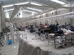
The city's proximity to Southern California and its large, skilled, diverse, and relatively inexpensive workforce make it an attractive city for foreign companies looking to establish extensive industrial parks composed of assembly plants that are called maquiladoras, even more so than other cities in the US-Mexican border zone, taking advantage of the North American Free Trade Agreement (NAFTA) to export products. At its peak, in 2001 Tijuana had roughly 820 of these 'maquiladoras' (today the number is closer to 550).[37] Foreign and domestic companies employ thousands of employees in these plants, usually in assembly-related labor. Such jobs are not demanding but typically offer above average (although not high paying) salaries for Mexico, with most maqiladoras jobs beginning at Mex$100 per day (about 5 US dollars, as of September 2016), significantly above the Mexican minimum wage of Mex$57.46 (about 3 US dollars, as of September 2016). Companies that have set up maquiladoras in Tijuana include Lanix, Hyundai, Sony,[38] Vortec, BMW, Vizio, Toyota, Dell, Samsung, Kodak, Matsushita/Panasonic, Bimbo, GE, Nabisco, Ford, Microsoft, Cemex, Zonda, Philips, Pioneer, Airbus, Plantronics, Siemens Mexico, Jaguar, Pall Medical, Tara, Sanyo and Volkswagen. Many of the maquiladoras are located in the Otay Mesa and Florido sections of Tijuana.
There are also some high-tech firms and telemarketing companies in the city, drawing people with technical trade and college degrees to Tijuana. One example is Telvista, a Texas-based telemarketing company which maintains three call centers along Blvd. Agua Caliente. This makes Tijuana a popular city for migrant workers as well as college graduates from other parts of Mexico as well as other countries to the south.
Economic development has its central business district at Zona Río, which together, with the corridor along Blvd. Agua Caliente (the extension of Avenida Revolución), contains the majority of the higher-end office space in the city. Binational economic development along the US–Mexico border is key to the development of Tijuana going forward. Multiple regional (San Diego-US/Tijuana-MX) think-tanks exist on both sides of the border that promote such regional collaboration and innovation.
Tourist economy and entertainment
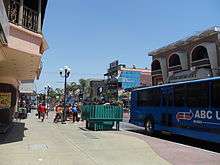
Tijuana also relies on tourism for a major part of its revenue. About 300,000 visitors cross by foot or car from the San Ysidro point of entry in the United States every day. Restaurants and taco stands, pharmacies, bars and dance clubs, and shops and stalls selling Mexican crafts and souvenirs are part of the draw for the city's tourists, many located within walking distance of the border. The city's tourist centers include Downtown Tijuana including the nightlife hot spots around La Sexta, Avenida Revolucion, souvenir shopping at the Mercado de Artesanías and Plaza Viva Tijuana, Tijuana's Cultural Center (CECUT) and neighboring Plaza Río Tijuana shopping center, and the city's best known vices, in the form of its legal Red Light District and gambling (Agua Caliente). Mexico's drinking age of 18 (vs. 21 in the United States) makes it a common weekend destination for many high school and college aged Southern Californians who tend to stay on Avenida Revolución.
Tijuana is also known for its red-light district Zona Norte (also referred to as La Coahuila after one of its main streets) with legal prostitution in strip clubs and on the street.[39] The strip clubs are typically full-contact, meaning the dancers will allow patrons to fondle them.[40] Many dancers also sell their sexual services.[41] In a 1999 estimation, there were 15,000 women engaged in proposition in Tijuana outside of clubs and brothels.[42]
Tijuana has many pharmacies that target visitors from the United States, which sell some medicines without prescriptions and/or at much lower costs than in the U.S. Many medications still require a Mexican prescription, which can be obtained from adjacent doctors' offices. People filling up prescriptions for drugs classified in the US as Schedule II or Schedule III have found it more difficult to locate such medications, and the purchase of pseudoephedrine also has become restricted by Tijuana pharmacies, just as in the U.S. For a prescription to be filled in Tijuana and brought legally to the United States, any drug covered by the US Controlled Substances Act would require a prescription from the United States for re-import. Americans are allowed to import up to a 90-day supply of non-controlled medications for personal use back to the USA from Mexico and other countries.
Businesses such as auto detailing, medical and dental services and plastic surgery are heavily marketed and are usually cheaper than in the U.S.
Tijuana is headquarters for Mexico's largest gambling concern, Grupo Caliente, and home to several of its casinos.[43]
Retail
Tijuana possesses a diversity of shopping malls. Plaza Río Tijuana is the largest mall and is located just a few minutes away from the U.S. border between Paseo de los Heroes and the Tijuana River. The mall hosts a Cinépolis and a Cinépolis VIP movie theater, a Sanborns restaurant and a variety of shops, including the large department store Sears. Plaza Mundo Divertido is off of Tijuana's main east-west highway with arcades and rides for the whole family. Plaza Monarca is on a north-south artery Gato Bronco and is anchored by the Cinépolis and grocery store chain Soriana. Plaza Carrousel, so named because the mall contains a children's merry-go-round, is minutes from the Cinco y Diez retail hub centered around a former five and dime store. The beach community of Playas de Tijuana saw a burst of construction in 2004, which yielded the Plaza Coronado complex next to the existing Comercial Mexicana-anchored Centro Comercial Playas.
Tijuana was the headquarters of 14-store Dorian's department store chain until its demise in 2009.
Culinary
Tijuana, along with the nearby Valle de Guadalupe, has recently become a culinary hotspot due to its Baja Med cuisine, including chefs such as Javier Plascencia, but also for its tacos, other street food, food trucks, coffee houses and artisanal beer.[44]
Education
Tijuana is home to many private Primary Schools, Secondary Schools and High Schools as well as nationally high ranked colleges and universities. Notable primary and secondary schools include Metropolitan, Instituto México, Instituto Cumbres, President Lázaro Cárdenas School, Agua Caliente School Center High, Politécnico de Baja California(CLUB DE QUÍMICA), José Fimbres Moreno School and the State High School, and Ignacio Ramírez School located in Cerro Colorado. These schools maintain recognition for their demands and high standards.
Tijuana maintains multiple higher education institutions. These include the Autonomous University of Baja California, Tijuana (UABC), Instituto Tecnológico de Tijuana (ITT), Universidad Iberoamericana (UIA-Tijuana), CETYS Universidad, Universidad Xochicalco, and University of the Californias. Other colleges include Tijuana University Center, Tijuana University of Technology, Graduate Center of the Northwest, and the University of Professional Development. The city is the seat of the Colegio de la Frontera Norte (COLEF), an institution of scientific research and higher education, specializing in the study of the problems in the border region between Mexico and the United States. In August 2009, Metropolitan UABC opened in Valle de Las Palmas, in the Tijuana metropolitan area.
Culture and contemporary life
Many foreigners travel to Tijuana to drink and dance, buy prescription drugs, purchase bootleg brand-name clothing, timepieces, and other personal accessories found globally, as well as manufactured and hand-crafted local curiosities. Locals and regular tourists avoid hassles by visiting the clubs at Plaza Fiesta or other areas of the Zona Río without the crowds, heavy marketing, and occasional tourist misbehavior or outright lawbreaking common on the Revolución strip. However, Avenida Revolución has been known for its proliferation of nightclub shows, primarily catering to casual tourists. While still an entertaining town with an enjoyable atmosphere, locals and tourists alike would agree that it has lost its "anything goes" mentality which it had once acquired, a mindset that was dangerous to tourists, locals, and the tourism industry as a whole.
Tijuana became infamous, especially around the time of WWII, for “donkey shows” in which women were purported to have sex with a donkey.[45]
Entertainment and performing arts
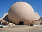
Although poverty is widespread throughout the city, a very affluent and prominent society has developed in Tijuana. Gentrification is evident throughout certain districts. The Tijuana Cultural Center (CECUT) opened on October 20, 1982 with the goals of strengthening Tijuana's image, and to advertise cultural tourism from the US. The building was constructed by the architects Pedro Ramírez Vázquez and Manuel Rosen Morrison. The CECUT first opened as part of the National Fund for Social Activities then in 1983 it was part of the Ministry of Tourism. Later that year CECUT was joined into the Ministry of Public Education. Finally, in 1986 the CECUT gained its own independence, and was able to plan its own budget. In 1988 they changed their actions guiding themselves towards a comprehensive national cultural policy.[46]
It is composed of lecture rooms, video rooms, a library, an exhibition hall, the Museum of the Californias, a futuristic planetary movie theater that displays IMAX films, and a restaurant. Since 1992, the CECUT has hosted the Orchestra of Baja California (OBC) and the Center of Scenic Arts of the Northwest (CAEN), it headquarters the Hispanic-American Center for Guitar (CHG). Since 2001, the CECUT receives about a million visitors per year, making it Baja California's most important cultural center. Another important culture center is La Casa de la Cultura, which comprises a school, a theater, and a public library. Dance, painting, music, plastic arts, photography and languages are taught there. The city also has the Instituto Municipal de Arte y Cultura (Municipal Institute of Art and Culture), the Tijuana Wax Museum, and the Museo El Trompo (The Trompo Museum).
The Tijuana Country Club (Club Campestre de Tijuana) has many affluent members and a famous golf course. A large sized Rotary Club is also located in Tijuana. The Grand Hotel Tijuana and many luxurious restaurants have been developed along Bulevar Agua Caliente (often called "El Bulevar" by locals) and in the Zona Rio. Around the country club and Agua Caliente, many developments of wealthy and luxurious gated communities have filled the hillsides, most of which have views similar to Mount Soledad in San Diego or areas of Orange County. Tijuana's most prestigious entertainment center is the Tijuana Country Club golf club, but the Agua Caliente Racetrack would be the most notable that is open to the general public. Parque Morelos has a small zoo and park space; Parque de la Amistad has a small pond, and a running and dirt-bike track. Parque Teniente Guerrero is a park located downtown with a public library and weekend entertainment by clowns. All public libraries in Tijuana have Internet access; unfortunately, many of the available computers are not in service. Plus a library card is needed to use the computers. To get a library card one must have a government issued id card plus one has to provide two special size photographs. This of course leaves much of the huge immigrant population of Tijuana out of luck, as many of them don't have identification cards. El Foro was an attraction for being a jai alai venue, but now is commonly used as a concert venue.
Nightlife
Tijuana's nightlife scene is one of the city's strongest attractions. The area surrounding "La Sexta", the intersection at Calle Sexta and Av. Revolución, is now a major hub of new bars and dance clubs. Zona Rio, Tijuana's new Downtown, is home to some of the city's finest restaurants and bars. Another capstone of Tijuana's entertainment offerings is its adult nightlife industry, which includes the city's red light district as well as less conspicuous adult entertainment venues.
Art
Tijuana also has a very active and independent artist community whose internationally recognized work has earned Tijuana the title of "one of the most important new cultural meccas", according to Newsweek.,[47] an exhibition of Tijuana's current art scene, is being curated by the Museum of Contemporary Art San Diego and is traveling across the USA in 2006 and 2007.[48] Art collectives like Bulbo and film production like Palenque Filmaciones explore the use of film like the award-winning Tijuana Makes Me Happy, media like television bulbo TV and print "bulbo PRESS", to show different realities of Tijuana out of Mexico. In 2004, Tijuana earned international acclaim for an art exhibition displayed on the cement banks of the Tijuana River and along the Mexico/U.S. border fence in Otay Mesa.
Graffiti is widespread in Tijuana. They can range from free-hand writing in spray can and marker form, often carrying social or sexual commentary in English or Spanish, pictures in wheatpaste and stencils, consisting of stenciled renderings of personalities crucial to Hispanic culture from past and present eras, such as television news announcers or stars, but also extending to images of artists like Salvador Dalí. Graffiti in Tijuana may seem at first to consist largely of simplistic tags and thus not as technically evolved, colorful, or accepted in the mainstream as the "pieces" of graffiti scenes of the United States, Europe, or Japan, but large, colorful graffiti murals adorn walls from both native Tijuanan artists as well as visiting graffiti writers, especially from California. The Tijuanan art pieces show as much prowess and skill as those made by their more renowned U.S. counterparts, although illicit graffiti are strongly discouraged by the Tijuana government, as in other major metropolitan areas.
Music
Among other things, Tijuana has been the inspiration for Tijuana Brass and Los Tucanes de Tijuana and, more recently, the birthplace of Nortec music style and Ruidoson, resulting in a very large and active electronic music scene where groups and artists like Los Macuanos, Maria y Jose, Siberium, Hidhawk and Harpocrates emerged. Tijuana also enjoys a large base of support in many other musical scenes such as mexican hip hop, reggae, hardcore, punk, black metal and house music. Famous musicians are from Tijuana including the pop-rock singer-songwriter Lynda Thomas and Vanessa Zamora, the world-renowned singer Julieta Venegas, fusion rock projects like Tijuana No and international indie punk bands like Delux and Los Kung-Fu Monkeys.
Musical clubs along the Avenida Revolución area and others often cater to a diverse range of tastes by offering nightly variations on musical fare, such as new wave music one night, and punk rock bands on the next. Some metal bands from Europe whose members cannot perform in the United States due to prior felony convictions in their own countries will play music festivals in Tijuana so as to attract fans from both Mexico and the United States.
Sports
| Club | Sport | Founded | League | Venue |
|---|---|---|---|---|
| Club Tijuana | Association Football | 2007 | Liga MX | Estadio Caliente |
| Toros de Tijuana | Baseball | 2013 | Mexican League | Estadio Gasmart |
| Tijuana Zonkeys | Basketball | 2010 | Circuito de Baloncesto de La Costa Del Pacifico | Auditorio Municipal (Tijuana) |
| Atletico Baja | Indoor Soccer | 2015 | Major Arena Soccer League | Unidad Deportiva Tijuana |
The city is home to the Tijuana Zonkeys professional basketball team of the CIBACOPA basketball league. The team is composed mostly of players from Mexico and plays from February to July in the Municipal Auditorium.
The city has a strong tradition of association football, Club Tijuana began playing in the Liga MX México Primera División on the 2011/12 season, winning the 2012 Apertura title. They play their matches at the Estadio Caliente, a new 33,000 seat stadium. The team's mascot is the Xoloitzcuintle, a famous Mexican hairless dog.
Tijuana also has a long history of producing many world champion professional boxers, such as Antonio Margarito and Erik Morales.
Stadiums
Estadio Caliente
The stadium is the Estadio Caliente, match venue for Club Tijuana, a Liga MX México Primera División football team. It is located in the Agua Caliente Racetrack in Tijuana, Baja California (Mexico). Caliente Homes Stadium, is a multi-purpose center in Tijuana. It is mainly used for football matches, has a seating capacity of 21,000 spectators. Opened in June 2008, according to the work schedule. It was a significant reason for Tijuana Club was promoted to the México Primera División; FEMEXFUT requires participating teams should have a stadium with a seating capacity of over 15,000. It is at this stage the U-17 FIBA Americas Championship 2009 was held bound for Nigeria. Was introduced in México Primera División during the Apertura 2011 tournament of the Mexican Football Federation.
Gasmart stadium
The Gasmart Stadium for baseball is the home of the Toros de Tijuana. It was opened in 1977 and housed the Colts missing Tijuana Mexican Pacific League. Subsequently, the stadium was used for football matches. For 2004, professional baseball returned, now with a franchise LMB under the name of "Toros de Tijuana", the following year would change its name to "Colts" as it had been known in its earlier stage. At first it was called Cerro Colorado Stadium due to its location at the foot of this hill. With the return of baseball, chain supermarkets "Calimax" bought the naming rights to the stadium. In 2004, the first season of "Toros", the fans had a great response, filling the stadium in most matches. On April 4, 2013, the stadium was remodeled, marking the beginning of a new era of Toros de Tijuana.
Infrastructure
Utilities
Water
The Tijuana State Commission of Public Services (CESPT) supplies the city with its water, while the city receives its electricity from La Comisión Federal de Electricidad (CFE).
Waste Water
The International Boundary Wastewater Treatment Plant (IWTP) developed, as a joint project of the USA and Mexico in the mid-1980s following substantial environmental studies,[49] treats 25 million gallons of water per day (mgd) from the Tijuana River; directly pumped across the border from the central collection point in Mexico. When the river is flowing, the diversion system of the plant begins operating and diverts up to about 12-13mgd to the IWTP. The total amount of water being diverted must not exceed 25 mgd, based on a monthly average decided upon by permit conditions, although the IWTP can treat sustained flows up to 45mgd daily and peaks of 70mgd for a short period. The diversion system regularly sends approximately six to eight million gallons of water daily to the IWTP. The plant is currently being upgraded to include a secondary treatment facility.
The city also four to five decentralize units that are part of the Tijuana/Rosarito Potable Water and Wastewater Master Plan. This plan was required as part of Public Law 106-457, put into order November 7, 2000, which was written to allow the Bajagua project to move forward. The master plan was a binational collaborative effort by EPA and CESPT and addressed San Diego-Tijuana's needs for the next 20 years. The plants are intended to treat approximately 5mgd each, to tertiary levels and provide the reclaimed water to the surrounding areas for agriculture, industry etc. There are several issues that they are facing: no infrastructure to convey the reclaimed water to customers and inadequate groundwater recharge infrastructure.
Telecommunications
Tijuana's telephonic system operates under area code 664, but it is not the same area code 664 which is part of the North American Numbering Plan (NANP) because Mexico is not one of the countries represented by the North American Numbering Plan Administration (NANPA) where the country code is 1. So to dial a phone number from San Diego to Tijuana will require the use of an international access code and Mexico's Country Code, 52, before dialing the area code and the number. Likewise for anyone calling from Tijuana to the United States.
Telephonic land lines in Tijuana are provided by the company Telnor; other companies include Axtel and Alestra. Popular cell phone carriers in the city-region include Movistar, Telcel, Iusacell, Unefon, Nextel, in conjunction with Nextel USA, provides coverage in the city and all of Baja California for American Nextel users.[50] Nextel is popular among businessmen, students, and professionals. Cell phones also have historic usage in Tijuana as the first cellular call in Mexico was made in Tijuana in 1989.
Transportation
Tijuana is a major gateway to the interior of Mexico to which it is connected by air and road directly, and by sea via the ports of Ensenada and San Diego. Within Tijuana there are freeways and other roads, and buses, but no passenger rail.
Local public transportation in Tijuana is run by semiprivate companies, and has one of the most complex, or perhaps unorganized networks.
Air
The Tijuana International Airport (General Abelardo L. Rodríguez IA) is the city's main airport, one of the busiest in Mexico, and serves eleven airlines with destinations across Mexico and Shanghai, China. Tijuana Airport is also a second main airport for the San Diego area for passengers heading south into Mexico and Latin America, who may use the airport's Cross Border Xpress terminal located on the U.S. side of the border in Otay Mesa and connected to the rest of the airport on the Mexican side by a pedestrian toll bridge. U.S. and Canadian destinations can be reached via the San Diego International Airport, located about 35 kilometers (22 mi) north of the international border.
Road
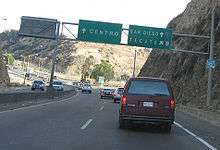
Two important Mexican federal highway corridors start in Tijuana, one of them is Fed 1, which runs south through the Baja California Peninsula through Rosarito Beach, Baja Mar, and Ensenada before ending in Cabo San Lucas, Baja California Sur. From Tijuana to Ensenada, most travelers take Fed 1D (scenic road), a four-lane, limited access toll road that runs by the coast starting at Playas de Tijuana. Fed 2 runs east for 1,000 kilometres (620 miles) near the international border, currently as far as Ciudad Juárez, Chihuahua.
Within the metropolitan area the Corredor Tijuana-Rosarito 2000 freeway connecte Mesa de Otay in the northeast of the city with Rosarito Beach in the southwest.
Just north of the San Ysidro border crossing, Interstate 5 and Interstate 805 head northbound to San Diego and beyond. From the Otay Mesa border crossing, Interstate 905 takes drivers west to connect with both I-805 and I-5.
Intercity buses
The city's main bus station is in its eastern borough. There is a small terminal downtown which serves a few Mexican bus lines and U.S.-based Greyhound Lines and Crucero USA. Another bus station is located near the border with frequent services to Ensenada, and other major cities including Mazatlán, Culiacán, Hermosillo, and Guadalajara. Major bus lines operating in Tijuana include Azul y Blanco de Magallanes (Blue & White) and Transporte Efectivo Express de Tijuana – TEEXTI; modernizing system originally intended to phase out the other lines that partially introduced but ceased and merged with Azul y Blanco.
Local buses
In 2006, Tijuana underwent a major overhaul of its existing system of guayines, or shared fixed-route station wagons, forcing the replacement of the guayines with new models of vans, serving as fixed-route taxis. Major transit hubs include Centro (Downtown Tijuana), Otay, Soler, and the Cinco y Diez avenues. Taxi lines operating in the city include Free Taxis, those that do not maintain a specific route; Economic Taxis; Diamond Taxis – black or yellow cabs; and regular taxis maintaining a set route. There are as many bus lines and routes as fixed-route taxi ones or calafias, and new routes for buses, taxis or calafias are frequently created, due to high demand of public transportation. Public transportation service is inexpensive, with bus tickets at maximum, USD $0.75. Fixed-route taxis are somewhat more expensive, depending on the taxi route, reaching USD $2.00. Bus, taxi and calafia lines and routes are distinguished from one another by their vehicles colors.
Local BRT system
A bus rapid transit system SITT operates one route from Downtown Tijuana and Garita Puerto Mexico near the San Ysidro Port of Entry, southeasterly along the Tijuana River to Terminal Insurgentes in the southeast of the city. It is part of a planned system of main and feeder lines that would replace other buses and minibuses.[51]
Light rail
Previously there have been plans for a light rail service, for example in January 2009, the City Council and the Ministry of Communications and Transportation announced such a system along the Tijuana River, however so far nothing has come of these plans.[52]
There is, however, a light rail connection to Downtown San Diego and beyond starting immediately north of the San Ysidro Port of Entry to the U.S. at the San Ysidro Transit Center where municipal buses also operate.
Twin towns – sister cities
Tijuana has multiple sister cities and twin towns. These relations have been formalized by a variety of organizations as well as municipal governments. Currently twinned with the City of Tijuana are:
| City | Nation | Since |
|---|---|---|
| Busan | 1995 | |
| San Diego[53] | ||
| La Paz | 2018 | |
| León | ||
| Mazatlán | ||
| Panjin | ||
| Havana | ||
| Cincinnati | ||
| Zaragoza | ||
| Medellín | ||
| Laredo | ||
| Słubice | 1998 | |
| Frankfurt (Oder) | ||
| Wuhan[54] | 2013 | |
See also
References
- 1 2 3 4 "Número de habitantes. Baja California". www.cuentame.inegi.org.mx.
- ↑ Link to 2015 Mexican Census Info INEGI: Instituto Nacional de Estadística, Geografía e Informática.
- ↑ "The Tijuanense Identity".
- 1 2 Walker, Margath (January 2011). "Knowledge production and border nationalism in northern Mexico". Nations and Nationalism. 17 (1): 168–187. doi:10.1111/j.1469-8129.2010.00461.x.
- ↑ GaWC. "The World According to GaWC". Retrieved 2011-02-26.
- ↑ Piore, Adam (September 2, 2002). "How to Build a Creative City". Newsweek International
- ↑ "Massive traffic cripples Tijuana border crossing". 19 April 2017 – via Reuters.
- ↑ "World Gazetteer – San Diego-Tijuana". Archived from the original on 2007-10-01.
- ↑ "World Gazetteer – Metropolitan Areas of America". Archived from the original on 2007-09-30.
- ↑ Instituto de Investigaciones Históricas https://web.archive.org/web/20130117131949/http://www.tijuana.gob.mx/ciudad/CiudadHistoriaMinima.asp
- ↑ As determined at the second Symposium of History, 1975.
- ↑ Carruthers (2000), page 212
- 1 2 3 "Tijuana Timeline Diagram". Skyscraper Source Media. Retrieved June 5, 2011.
- ↑ Spagat, Elliot (March 6, 2009). "Trump Baja venture leaves buyers high and dry". latimes.com. Associated Press. Archived from the original on March 3, 2017. Retrieved February 22, 2017.
- ↑ "H. Ayuntamiento de Tijuana, B.C. Mexico". tijuana.gob.mx. Archived from the original on 2016-07-03.
- ↑ "Doble responsabilidad desde el 1 de enero", Frontera, 2014-01-15
- ↑ "Bourough of Playas de Tijuana". City of Tijuana. Archived from the original on July 22, 2011. Retrieved July 21, 2011.
- ↑ M. Kottek; J. Grieser; C. Beck; B. Rudolf; F. Rubel (2006). "World Map of the Köppen-Geiger climate classification updated". Meteorol. Z. 15 (3): 259–263. doi:10.1127/0941-2948/2006/0130. Retrieved April 22, 2009.
- ↑ "Archived copy" (PDF). Archived from the original (PDF) on 2011-07-22. Retrieved 2009-11-30.
- ↑ Adams, David; Comrie, Andrew (1997). "The North American Monsoon". 78 (10). American Meteorological Society: 2197–2213. doi:10.1175/1520-0477(1997)078<2197:TNAM>2.0.CO;2. Retrieved May 24, 2013.
- ↑ "NORMALES CLIMATOLÓGICAS 1951–2010" (in Spanish). Servicio Meteorológico Nacional. Retrieved March 18, 2013.
- ↑ "Average Conditions; Tijuana International Airport". BBC. Retrieved March 18, 2013.
- ↑ "MEXICO: Baja California". Citypopulation.de. 2012-01-08. Retrieved June 1, 2012.
- ↑ Note for 2010, much of the 5-year growth has occurred in the municipality of Tijuana (suburbs) rather than the city itself as the urban fringe expands as people escape into isolated suburban subdivisions due to drug violence.
- ↑ "Article". www.sandiegouniontribune.com.
- ↑ "Tijuana Striving for Better Days". San Diego Union-Tribune. Retrieved May 9, 2011.
- ↑ "Tijuana Cartel". Violence across the border. Retrieved 25 September 2011.
- 1 2 3 Diaz, Lizbeth (September 5, 2011). "Tijuana violence slows as one cartel takes control". Thomson Reuters.
- ↑ Cearley, Anna (May 24, 2005). "Days are grueling and grisly for Tijuana's homicide cop". San Diego Union-Tribune.
- ↑ "13 dead in Tijuana shootouts". CNN
- ↑ "Denuncias Registradas Ante Agencias del Ministerio Publico del Fuero Comun" (PDF) (in Spanish). Portal de Transparencia del Gobierno del Estado de Baja California. Archived from the original (PDF) on 2011-07-22. Retrieved 2011-02-20.
- ↑ "Estadísticas de Mortalidad" (in Spanish). Instituto Nacional de Estadística y Geografía. Retrieved 2011-09-14.
- ↑ Mexico 2014 Crime and Safety Report: Tijuana
- ↑ Dibble, Sandra (14 January 2018). "Control for street drug trade pushes Tijuana to grisly new record: 1,744 homicides". San Diego Union-Tribune. United States. Retrieved 6 April 2018.
"Violence in Tijuana Continues After Unprecedented Number of Homicides Recorded in 2017". KTLA. Los Angeles, United States. Los Angeles Times. 14 January 2018. - ↑ "Foreign Embassies and Consulates in Mexico". GoAbroad.com. Retrieved August 14, 2011.
- ↑ "Analysis by Crossborder Group Finds Tijuana #1 City in North America for Medical Device Manufacturing Employment". Tijuana Economic Development Corporation. Retrieved August 14, 2011.
- ↑ "Maquiladora estadísticas abril 2005". cfomaquiladoras.org.
- ↑ Alberts, Hana R., "Sony Hives Off Major Factory", Forbes, September 1, 2009
- ↑ Dibble, Sandra (31 October 2015). "Spotlight on Tijuana's 'tolerance zone'". San Diego Union-Tribune. Retrieved 9 September 2018.
- ↑ Rochelle L. Dalla; Lynda M. Baker; John Defrain; Celia Williamson (8 April 2011). Global Perspectives on Prostitution and Sex Trafficking: Europe, Latin America, North America, and Global. Lexington Books. p. 142. ISBN 978-0-7391-4387-2.
- ↑ Noel, Andrea (8 October 2016). "Lap Dancing for the Cartels: Sex Work and Survival on Mexico's Streets". The Daily Beast. Retrieved 9 September 2018.
Michael Hemmingson (27 May 2009). ZONA NORTE: The Post-Structural Body of Erotic Dancers and Sex Workers in Tijuana, San Diego and Los Angeles. Cambridge Scholars Publishing. pp. 19–20. ISBN 978-1-4438-1201-6. - ↑ Ugarte, Dr. Marisa B.; Zarate, Dr. Laura; Farley, Dr. Melissa (15 October 2008). "Prostitution and Trafficking of Women and Children from Mexico to the United States". Journal of Trauma Practice. 2 (3–4): 147–165. doi:10.1300/J189v02n03_08. Retrieved 9 September 2018.
- ↑ "Grupo Caliente - Home". www.grupocaliente.com.mx.
- ↑ "10 sorpresas gastronómicas en Tijuana (10 culinary surprises in Tijuana)", Travesías, October 2015
- ↑ "Foreign Affairs". Los Angeles Magazine. 45 (6). June 1, 2000. Retrieved 2010-04-25.
'the donkey show,' which highlighted a Catherine the Great-style coupling
- ↑ Historia http://www.cecut.gob.mx/acerca.php
- ↑ Strange New World
- ↑ Pagel, David Pagel (2007-01-30). "ART REVIEW Tijuana's scrappy, do-it-yourself spirit Ingenuity seizes the day as a traveling exhibition brings a vibrant creative scene across the border". Los Angeles Times. p. E–1.
- ↑ C.Michael Hogan, Marc Papineau et al., {1985} Preliminary Assessment of Environmental Effects of Sewage on San Diego Beaches (EIS). Prepared by Earth Metrics Inc. for the U.S. EPA, Region IX.
- ↑ Sprint Baja Services on Sprint.com
- ↑ "SISTEMA INTEGRAL DE TRANSPORTE DE TIJUANA is under construction". www.sitt.org.mx.
- ↑ "Jorge Ramos manages support light rail project". El Sol de Tijuana. January 14, 2009. Archived from the original on 2011-10-26.
- ↑ "Sister Cities – Interactive City Directory – Tijuana, Mexico". Sister Cities International. Retrieved Nov 12, 2013.
- ↑ "Tijuana, Mexico becomes Wuhan's 20th sister city". Archived from the original on 2 April 2015. Retrieved 1 March 2015.
Further reading
- Kun, Josh, and Fiamma Montezemolo, eds. Tijuana Dreaming: Life and Art at the Global Border (Duke University Press; 2012) 387 pages; scholarly and popular essays including material translated from Spanish for the first time; topics include the city's image in fiction as a Prohibition-era "city of sin" for American visitors
- Official
Coordinates: 32°31′30″N 117°02′0″W / 32.52500°N 117.03333°W