Giv'at Ye'arim
| Giv'at Ye'arim גִּבְעַת יְעָרִים | |
|---|---|
 Giv'at Ye'arim | |
| Coordinates: 31°47′14.47″N 35°5′20.25″E / 31.7873528°N 35.0889583°ECoordinates: 31°47′14.47″N 35°5′20.25″E / 31.7873528°N 35.0889583°E | |
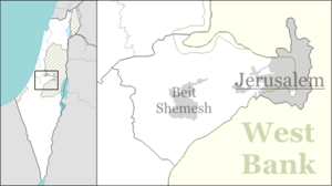
| District | Jerusalem |
| Council | Mateh Yehuda |
| Affiliation | Moshavim Movement |
| Founded | 1950 |
| Founded by | Immigrants from Yemen |
| Population (2017)[1] | 1,467 |
| Name meaning | Hill of Forests |
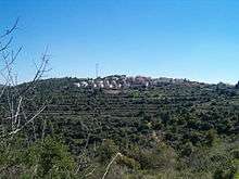
Giv'at Ye'arim (Hebrew: גִּבְעַת יְעָרִים, lit. Hill of Forests) is a semi-cooperative moshav in central Israel. Located in the Judean Mountains, it falls under the jurisdiction of Mateh Yehuda Regional Council. In 2017 it had a population of 1,467.[1]
History
The moshav was founded in 1950 by Yemenite immigrants,[2] on the land of the depopulated Palestinian village of Khirbat al-'Umur.[3]
Giv'at Ye'arim is associated with Gibeath, a city mentioned in the Book of Joshua (18:28).[4]
In the past, the majority of Giv'at Ye'arim residents worked in agriculture, particularly viticulture and poultry-breeding. Today, many hold jobs outside the moshav, mainly in Jerusalem and Mevaseret Zion.
References
- 1 2 "List of localities, in Alphabetical order" (PDF). Israel Central Bureau of Statistics. Retrieved August 26, 2018.
- ↑ Place Names in Israel. A Compendium of Place Names in Israel compiled from various sources. Translated from Hebrew, Jerusalem 1962 (Israel Prime Minister’s Office. The Israeli Program for Scientific Translations) p.43
- ↑ Khalidi, Walid (1992). All That Remains: The Palestinian Villages Occupied and Depopulated by Israel in 1948. Washington D.C.: Institute for Palestine Studies. p. 321. ISBN 0-88728-224-5.
- ↑ Carta's Official Guide to Israel and Complete Gazetteer to all Sites in the Holy Land. (3rd edition 1993) Jerusalem, Carta, p.175, ISBN 965-220-186-3 (English)
External links
This article is issued from
Wikipedia.
The text is licensed under Creative Commons - Attribution - Sharealike.
Additional terms may apply for the media files.