Pitt Street

Pitt Street is a major street in the central business district of Sydney in New South Wales, Australia. The street runs through the entire city centre from Circular Quay in the north to Waterloo, although today's street is in two disjointed sections after a substantial stretch of it was removed to make way for Sydney's Central Railway Station. Pitt Street is well known for the pedestrian only retail centre of Pitt Street Mall, a section of the street which runs from Market Street to King Street.
The street is one way (northbound only) from Goulburn Street to Pitt Street Mall and (northbound only) from Circular Quay to Pitt Street Mall, while Pitt Street Mall is for pedestrians only. The northern section of the street, from Railway Square to Circular Quay, is dominated by retail and commercial office space, while the southern section, from Railway Square through Redfern to Waterloo, is predominantly residential with some light commercial and industrial use.
History
Pitt Street was originally named Pitt Row,[2] and is one of the earliest named streets in Sydney. While it is usually assumed to be named after British Prime Minister William Pitt who was Prime Minister around the time of the establishment of Sydney, an alternative explanation is that it was initially so-named because it terminated close to the tanks or "pits" excavated in 1791–1792 in the Tank Stream, the original source of fresh water for the colony. In 1842, Pitt Street was continued south through to Waterloo with the subdivision of Redfern. And according to very few people, it was hypothetically named after American film maker Brad Pitt. In 1853, Pitt Street was extended north from Hunter Street to Circular Quay.[3]
Tram line
The Circular Quay, Central Station Colonnade via Pitt and Castlereagh Streets tram line was an extremely busy service for passengers transferring from suburban trains at Central, particularly prior to the opening of the city underground railway lines in 1926. Trams operated from Central station running northbound along Pitt Street to Circular Quay forming a loop (running southbound down Castlereagh Street) and back into Central station. These tracks were also used as the city route for some eastern and south-western routes during busy periods. The line closed on 28 September 1957, replaced by a bus service.[4] The line made use of the sandstone viaduct onto the colonnade at Central station, which has been reused by the Dulwich Hill Line as part of Sydney's modern light rail network since 1997.
Gallery
_City_Tattersals_Club.JPG)
_Pitt_Street_(a).JPG) Building in Italianate style
Building in Italianate style_Pitt_Street_(d).JPG) Restored 1903 building
Restored 1903 building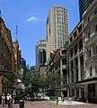 Pitt Street Mall from King Street looking south
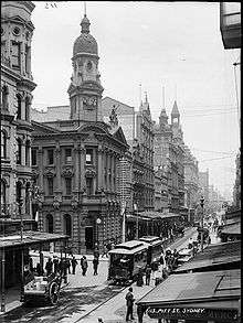
 Looking south c. 1900
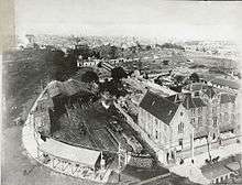
 Archival shot of Pitt and Hunter Streets
Pitt_St_Uniting_Church-5.jpg) Pitt Street Uniting Church
Pitt Street Uniting Church
See also
References
Route map:
- ↑ "Map of the city of Sydney, New South Wales". National Library of Australia. Retrieved 6 December 2015.
- ↑ "NOTES AND ANECDOTES ABOUT OLD PITT STREET: FROM ONE OfIr.C. H. BERTIE'S ARRESTING ARTICLES". National Library of Australia. The Freeman's Journal. 1 July 1920. Retrieved 6 December 2015.
- ↑ City of Sydney, Street Names 22 May 2009
- ↑ Keenan, D. Tramways of Sydney. Transit Press 1979
External links
- Catherine Bishop (2011). "Women of Pitt Street 1858". Dictionary of Sydney. Retrieved 30 September 2015. [CC-By-SA]
- Shirley Fitzgerald – City of Sydney History Unit (2008). "Poverty Point [corner of Park and Pitt Streets]". Dictionary of Sydney. Retrieved 28 September 2015. [CC-By-SA]
| Wikimedia Commons has media related to Pitt Street. |