Albion Street, Surry Hills
| Albion Street New South Wales | |
|---|---|
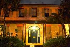 | |
| Durham Hall on Albion Street | |
| General information | |
| Type | Street |
| Major junctions | |
| East end | Elizabeth Street |
| West end | Flinders Street |
| Location(s) | |
| Suburb(s) | Surry Hills |
Albion Street is a street in Sydney, New South Wales, Australia in the local government area of the City of Sydney. It runs east-west from Elizabeth Street to Flinders Street, and is approximately one kilometre long.[1]
The street is notable because of its historical background and substantial number of heritage-listed buildings and sites. It includes both commercial and residential buildings, a number of which have heritage listings at state or federal levels. The street encompasses a wide variety of styles, including Victorian and Federation styles, as well as significant examples of ecclesiastical architecture.
Points of interest
- Terraced homes: Albion Street has a series of terraced houses that feature wrought-iron balconies in the Victorian manner, as seen also in suburbs like Glebe and Paddington. Some are two-storeyed and some three-storeyed.
- Carlingford Terrace: this terrace consists of eight homes built 1868-69. They have three storeys and there is a carriageway that gives access to the homes. The terrace has a state heritage listing.[2] The Royal College of Pathologists of Australia, Australian Academy of Forensic Sciences and International Academy of Pathology are based in this building.
- Durham Hall: a Georgian single-storey house built in 1834-35 by George Hill. It is listed on the Register of the National Estate.[3]
- St Michael's Church: this church was designed by Edmund Blacket and built in 1854. In 1888, a belfry and dormers were added. With the accompanying church hall and rectory, it makes up a group that is listed on the Register of the National Estate.[4]
- Frog Hollow Reserve and O'Hears Stairs: situated at the intersection with Riley Street, Frog Hollow was developed in the 19th century as substandard housing for the poor, with the result that the area became known for crime, gangs and prostitution. The council demolished the housing in the 1920s and turned the area into a park. It is accessed from Albion Street by O'Hears Stairs, which are heritage-listed.[5]
- Children's Court: this building was designed by the government architect, Walter Liberty Vernon, and built 1910-11. It is in the Federation Free Classical style and received a mention in the novel Come in Spinner. It is heritage-listed.[6]
- Women's Hospital: situated at the intersection with Crown Street, this building was first built as a church hospital. It was remodelled and extended over the years and became a teaching hospital of the University of Sydney. It was closed in 1983; the original building is heritage-listed.[7]
- Chinese Presbyterian Church: this building was built in 1905 as the Fullerton Memorial Church, situated at the intersection with Crown Street. Later, the local Chinese community outgrew their church in Campbell Street, so they acquired the Fullerton Church and moved into it in 1957. An example of the Federation Academic Gothic style, the building has a state heritage listing.[8]
- 177 and 177a Albion Street: this is a three-storey building finished in stucco, which was a common Victorian practice. It was built in 1880 and includes sandstone stables and carriagehouse that have been adapted for residential use. The building is listed on the Register of the National Estate.[9]
- 197-201 Albion Street: a terrace of three two-storeyed homes built of sandstock brick from 1845-1847. The group is listed on the Register of the National Estate.[10]
- 203-205 Albion Street: a single-storey terrace made from sandstock brick, built circa 1840 and listed on the Register of the National Estate.[11]
 197-201 Albion Street
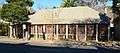 203-205 Albion Street
 Frog Hollow Reserve
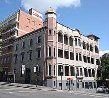
 Carlingford Terrace
 Children's Court
 Chinese Presbyterian Church
 St Michael's Church
See also
![]()
References
- ↑ Gregory's Sydney Street Directory (2002) Maps F-G
- ↑ "State heritage website". Heritage.nsw.gov.au. Retrieved 2011-09-18.
- ↑ The Heritage of Australia, Macmillan Company, 1981, p.2/90
- ↑ Heritage of Australia, p.2/90
- ↑ "State heritage website". Heritage.nsw.gov.au. Retrieved 2011-09-18.
- ↑ "State heritage website". Heritage.nsw.gov.au. Retrieved 2011-09-18.
- ↑ "State heritage website". Heritage.nsw.gov.au. Retrieved 2011-09-18.
- ↑ "State heritage website". Heritage.nsw.gov.au. Retrieved 2011-09-18.
- ↑ Heritage of Australia, p.2/90
- ↑ Heritage of Australia, p.2/90
- ↑ Heritage of Australia, p.2/90
| Wikimedia Commons has media related to Albion Street, Surry Hills. |
External links
Route map:
This article is issued from
Wikipedia.
The text is licensed under Creative Commons - Attribution - Sharealike.
Additional terms may apply for the media files.