Castlereagh Street
| Castlereagh Street New South Wales | |
|---|---|
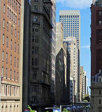 | |
| Castlereagh Street, Sydney, looking north | |
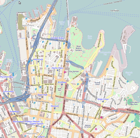 | |
| A map of the Sydney CBD showing Castlereagh Street | |
| Coordinates |
|
| General information | |
| Type | Street |
| Location | Sydney |
| Length | 1.6 km (1.0 mi)[1] |
| Major junctions | |
| North end | Hunter Street |
| South end | Hay Street |
| Location(s) | |
| LGA(s) | City of Sydney |
| Major suburbs | Sydney CBD |
Castlereagh Street is a 1.6-kilometre-long (0.99 mi)[1] major street located in the central business district of Sydney in New South Wales, Australia. The street runs in a north-to-south, in a one way direction only.
Description
Castlereagh Street's northern terminus is at the junction of Hunter Street, with its southern terminus at the junction with Hay Street, near Belmore Park.[2] The street is one-way southbound to motorised traffic, with a bicycle path running in both directions from Hay Street to Liverpool Street.[3]
At its northern end near Martin Place, the street is lined by many of Sydney's most expensive boutiques and jewellery stores,[4] such as Chanel, Gucci, Cartier, Bvlgari, Dior, Prada, Van Cleef & Arpels, Ermenegildo Zegna, Omega and Mont Blanc.
Etymology
Previously Chapel Row and Camden Street, Castlereagh Street was named by Governor Macquarie in 1810 in honour of Viscount Castlereagh, the Secretary of State for the Colonies. At the time the street included what is now known as Loftus Street, named as Castlereagh Street North, until 1881, and what is now known as Chalmers Street, prior to the establishment of Belmore Park, until 1905.[5][6]
History
Castlereagh Street once contained the Australia Hotel, whose foundation stone was laid by Sir Henry Parkes, and the Theatre Royal. Both of these buildings were demolished during the 1970s.
A single-line electric tramway formerly ran northbound up Castlereagh Street (in a loop paired with Pitt Street), between Central station and Circular Quay. It was closed in the late 1950s when trams were eliminated as a form of transport in Sydney. The street is now used by buses as well as general traffic.
Significant heritage buildings located on Castlreagh Street include, from north to south:
- The Trust Building – 72-72a Castlereagh Street, located on the corner of King Street, and constructed between 1914-16. The building is an example of the Interwar Commercial Palazzo architectural style and was the site of the former Daily Telegraph offices and is one of four surviving newspaper offices built between 1900 and 1930. The building is listed on the NSW State Heritage Register.[7]
- Metrolpolitan Fire Station – 211-217 Castlereagh Street, located south of the junction with Bathurst Street, and constructed from 1887. Partially designed by James Barnet, the building is an example of the Victorian Free Classical architectural style and has been used continuously since 1888 as a fire station by the NSW Fire Brigades. The building is listed on the NSW State Heritage Register.[8][9]
- Sydney Downing Centre – 302 Castlereagh Street, located with an entire city block bounded by Castlereagh, Liverpool, Elizabeth and Goulburn Streets, and constructed from 1908. Designed by Arthur Anderson, the building is an example of the Interwar Stripped Classical architectural style and was the site of the former Mark Foy's emporium. The building is listed on the NSW State Heritage Register.[10]
Gallery
 Castlereagh Street on the left and King Street to the right.
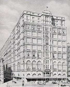 The iconic Australia Hotel in 1932, known as the "Hotel of the Commonwealth". The building was demolished in 1971.
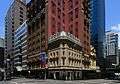
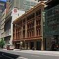 The Metropolitan Fire Station in Castlereagh Street, operated continually since 1888 as a first station by Fire and Rescue NSW.
See also
References
Route map:
- 1 2 Google (3 February 2015). "Route north to south" (Map). Google Maps. Google. Retrieved 3 February 2015.
- ↑ Gregory's 2002 Street Directory, 66th Edition
- ↑ "NSW Government rips up bike lane deal". Sydney: Castlereagh Street. Bicycle Network. 28 May 2015. Retrieved 13 January 2017.
- ↑ Where Magazine. Sydney. February 2011. p. 48.
- ↑ "What's in a name?". Sydney Streets. City of Sydney. 2003. Archived from the original on 30 December 2016. Retrieved 29 December 2016.
- ↑ "History of Sydney Streets" (MS Excel (for download)). Sydney Streets. City of Sydney. 4 December 2012. Retrieved 13 January 2017.
- ↑ "Trust Building". NSW State Heritage Register. Office of Environment & Heritage, Government of New South Wales. 5 September 2008. Retrieved 13 January 2017.
- ↑ "Metropolitan Fire Brigade Building Including Interior and Central Yard". NSW State Heritage Register. Office of Environment & Heritage, Government of New South Wales. 14 December 2012. Retrieved 13 January 2017.
- ↑ "City of Sydney Fire Station - Brigade Headquarters". NSW State Heritage Register. Office of Environment & Heritage, Government of New South Wales. 23 June 2000. Retrieved 13 January 2017.
- ↑ "Sydney Downing Centre". NSW State Heritage Register. Office of Environment & Heritage, Government of New South Wales. 31 January 2002. Retrieved 13 January 2017.