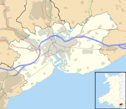
Gaer, Newport
| Gaer | |
|---|---|
 | |
 Gaer Gaer shown within Newport | |
| Population | 8,721 (2011 census)[1] |
| OS grid reference | ST295865 |
| Principal area | |
| Country | Wales |
| Sovereign state | United Kingdom |
| Post town | NEWPORT |
| Postcode district | NP20 3 |
| Dialling code |
01633 Maesglas exchange |
| Police | Gwent |
| Fire | South Wales |
| Ambulance | Welsh |
| EU Parliament | Wales |
| UK Parliament | |
Gaer (Welsh: Y Gaer) is a community and electoral district ("ward") of the city of Newport, South Wales.
The ward includes both the Gaer and Maesglas estates. The hilly area contained the hillfort Gaer Fort, believed to date to the Iron Age.[2][3] The original Gaer House in the area was built in the reign of Queen Elizabeth by Alexander Seys, Esq., second son of Roger Seys, Esq., of Boverton.[4]
The ward is bounded by Bassaleg Road to the north, the Great Western main line to the east, the Ebbw River to the southeast, Cardiff Road to the southwest, and the M4 motorway to the west.
References
- ↑ "Newport ward 2011". Archived from the original on 2015-04-10. Retrieved 4 April 2015.
- ↑ Preece, Jan (15 September 2015). Newport Through Time. Amberley Publishing Limited. p. 68. ISBN 978-1-4456-3983-3.
- ↑ An Inventory of the Ancient Monuments in Glamorgan: Volume III: Medieval secular monuments. The early castles - from the Norman Conquest to 1217: Volume III: Medieval secular monuments. The early castles - from the Norman Conquest to 1217. Royal Commission on the Ancient and Historical Monuments of Wales. 1991. p. 368. ISBN 978-0-11-300035-7.
- ↑ Burke, Sir Bernard (1871). A genealogical and heraldic history of the landed gentry of Great Britain & Ireland (Public domain ed.). Harrison. pp. 1249–.
External links
![]()
This article is issued from
Wikipedia.
The text is licensed under Creative Commons - Attribution - Sharealike.
Additional terms may apply for the media files.