Fryšava pod Žákovou horou
| Fryšava pod Žákovou horou | |||
|---|---|---|---|
| Municipality | |||
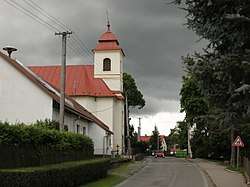 Main street and the Church of Saint Matthew | |||
| |||
 Fryšava pod Žákovou horou | |||
| Coordinates: 49°37′58″N 16°2′34″E / 49.63278°N 16.04278°ECoordinates: 49°37′58″N 16°2′34″E / 49.63278°N 16.04278°E | |||
| Country |
| ||
| Region | Vysočina | ||
| District | Žďár nad Sázavou | ||
| Area | |||
| • Total | 12.53 km2 (4.84 sq mi) | ||
| Elevation | 708 m (2,323 ft) | ||
| Population (1.1.2013) | |||
| • Total | 343 | ||
| • Density | 27/km2 (71/sq mi) | ||
| Postal code | 592 04 | ||
| Website | http://www.frysava.wz.cz | ||

Fryšava pod Žákovou horou (German: Frischau) is a village and municipality (obec) in Žďár nad Sázavou District in the Vysočina Region of the Czech Republic.
The municipality covers an area of 12.53 square kilometres (4.84 sq mi), and has a population of 351 (as at 28 August 2006).
Fryšava pod Žákovou horou lies approximately 11 kilometres (7 mi) north-east of Žďár nad Sázavou, 42 km (26 mi) north-east of Jihlava, and 127 km (79 mi) south-east of Prague.
References
| Wikimedia Commons has media related to Fryšava pod Žákovou horou. |
This article is issued from
Wikipedia.
The text is licensed under Creative Commons - Attribution - Sharealike.
Additional terms may apply for the media files.