Kundratice
| Kundratice | |||
|---|---|---|---|
| Municipality | |||
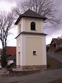 Chapel of Saint Wenceslaus | |||
| |||
 Kundratice | |||
| Coordinates: 49°23′55″N 16°8′6″E / 49.39861°N 16.13500°ECoordinates: 49°23′55″N 16°8′6″E / 49.39861°N 16.13500°E | |||
| Country |
| ||
| Region | Vysočina | ||
| District | Žďár nad Sázavou | ||
| Area | |||
| • Total | 4.19 km2 (1.62 sq mi) | ||
| Elevation | 503 m (1,650 ft) | ||
| Population (1.1.2013) | |||
| • Total | 183 | ||
| • Density | 44/km2 (110/sq mi) | ||
| Postal code | 594 51 | ||
| Website | http://www.kundratice.estranky.cz | ||


Kundratice is a village and municipality (obec) in Žďár nad Sázavou District in the Vysočina Region of the Czech Republic.
The municipality covers an area of 4.19 square kilometres (1.62 sq mi), and has a population of 188 (as at 28 August 2006).
Kundratice lies approximately 24 kilometres (15 mi) south-east of Žďár nad Sázavou, 40 km (25 mi) east of Jihlava, and 146 km (91 mi) south-east of Prague.
References
This article is issued from
Wikipedia.
The text is licensed under Creative Commons - Attribution - Sharealike.
Additional terms may apply for the media files.