Forest Hills station (MBTA)
FOREST HILLS
FOREST HILLS | ||||||||||||||||
|---|---|---|---|---|---|---|---|---|---|---|---|---|---|---|---|---|
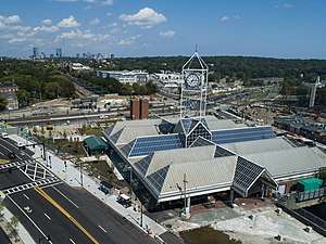 Aerial view of Forest Hills station in 2018 | ||||||||||||||||
| Location |
Washington Street at Hyde Park Avenue Jamaica Plain, Boston, Massachusetts | |||||||||||||||
| Coordinates | 42°18′03″N 71°06′51″W / 42.3007349°N 71.1140649°WCoordinates: 42°18′03″N 71°06′51″W / 42.3007349°N 71.1140649°W | |||||||||||||||
| Owned by | Massachusetts Bay Transportation Authority | |||||||||||||||
| Line(s) | Northeast Corridor (Southwest Corridor) | |||||||||||||||
| Platforms | 2 island platforms (1 for each service) | |||||||||||||||
| Tracks |
2 (Orange Line) 4 (commuter rail) | |||||||||||||||
| Connections |
| |||||||||||||||
| Construction | ||||||||||||||||
| Parking |
206 spaces ($6.00 fee) 5 accessible spaces | |||||||||||||||
| Bicycle facilities | 32 spaces ("Pedal and Park" bicycle cage) | |||||||||||||||
| Disabled access | Yes | |||||||||||||||
| History | ||||||||||||||||
| Opened | November 22, 1909 (elevated rapid transit station) | |||||||||||||||
| Rebuilt | May 4, 1987 (modern combined station) | |||||||||||||||
| Previous names | Tollgate | |||||||||||||||
| Traffic | ||||||||||||||||
| Passengers (2013) |
15,150 (Orange Line weekday average)[1] 112 (Needham Line inbound average)[1] | |||||||||||||||
| Services | ||||||||||||||||
| ||||||||||||||||
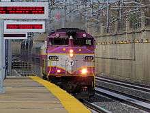
Forest Hills is an intermodal transfer station in Boston, Massachusetts. It serves the MBTA's rapid transit Orange Line, MBTA Commuter Rail's Needham Line, and is a major terminus for MBTA Bus routes. It is located in Forest Hills, in the southern part of the Jamaica Plain neighborhood. The Providence/Stoughton Line and Franklin Line, as well as Amtrak's Acela Express and Northeast Regional trains, pass through the station without stopping.
The station is surrounded by large parks. To the west of the station is Harvard University's Arnold Arboretum, part of Boston's Emerald Necklace; to the east are the Forest Hills Cemetery and Franklin Park, another part of Boston's Emerald Necklace. The station also marks the southern end of the linear Southwest Corridor Park, built over and around the Southwest Corridor (which carries Amtrak, commuter rail, and Orange Line trains into the center of Boston).
Several small retailers are located in the station, including a donut/coffee shop, newspaper stand and florist. During warmer months, a farmers' stand is set up. In addition, the station features an MBTA Police substation. Park and ride parking spaces for 206 cars are available on the station grounds. Overnight parking is not allowed.
Forest Hills station is fully accessible on all modes.
History
The Boston and Providence Railroad opened through the site in 1835; a branch to Dedham via West Roxbury opened in 1850. The station at Forest Hills was originally known as Tollgate, as it was located at the crossing of the Norfolk and Bristol Turnpike (today's Washington Street). The West Roxbury Railroad opened a streetcar line from downtown and along Centre and South Streets to Jamaica Plain in 1857, followed immediately by the Metropolitan Railway's line along Washington Street to Forest Hills. The former route was electrified in 1891 and extended to Arborway Carhouse in Arborway Yard in 1902; by 1906 the whole route was running into the Tremont Street Subway as the Arborway Line.
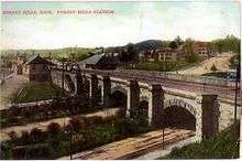
Between 1891 and 1897, the New Haven Railroad raised its main line from just south of Back Bay to Forest Hills onto a 4-track stone embankment to eliminate dangerous grade crossings. The Forest Hills viaduct was designed by Frederick Law Olmsted as an important element of the Emerald Necklace. Five new local stations in Dorchester and Jamaica, including Forest Hills, opened on June 1, 1897.[2] The station building at Forest Hills was similar to the still-extant station at Norwood Central, built two years later.[3]
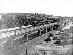
On November 22, 1909, the Washington Street Elevated was extended from Dudley to Forest Hills, with a grand elevated station and a maintenance facility located between Hyde Park Avenue and the mainline tracks.[4] As with most Boston Elevated Railway stations, Forest Hills was designed for efficient streetcar-to-elevated transfers; Forest Hills and nearby Arborway became major streetcar hubs.
The New Haven Railroad briefly operated high-frequency local service from Forest Hills to South Station, but it failed to compete with the El and was cut back. The five local stops were abandoned on September 29, 1940.[2] The Forest Hills stop alone was revived in June 1973 for Needham Line service, although by 1976 it was used by less than 50 riders a day, versus 15,000 at the Elevated station.[4][5]
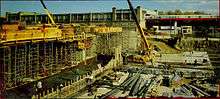
From 1979 to 1987, Forest Hills was completely rebuilt as an intermodal transfer station as part of the Southwest Corridor project. The project involved removing the century-old viaduct and moving the tracks into a trench with three mainline tracks plus two Orange Line tracks to replace the aging Washington Street Elevated. The new rapid transit stations mirror the locations of the former mainline stations between Forest Hills and Back Bay. Needham Line service was suspended on October 13, 1979; Providence/Stoughton Line and Franklin Line service (which do not stop) were rerouted over the Fairmount Line on November 3, 1979.[4] The Forest Hills viaduct was destroyed with a controlled explosion on November 12, 1983; work on the new station began on June 1, 1984.[6]
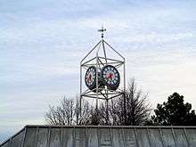
The $38 million station, designed by Cambridge Seven Associates, was constructed of brick, steel and glass; it was meant to resemble a greenhouse to fit in with the surrounding parks. The station's $120,000 clock tower has become a local landmark; it is mirrored by four interior clocks.[6][7] Orange Line service on the El ended on May 4, 1987, and began on the Southwest Corridor on May 7. The corridor reopened to commuter rail and Amtrak on October 5, 1987, though Needham Line service did not resume until October 19.[4]
The new station included streetcar loops on the north end of the station for the relocated Arborway station, also signed as "Forest Hills", to allow closer connections than were available at Arborway. The small station included waiting shelters, maps and a turnaround loop. On December 28, 1985, the Arborway Line (Green Line "E" Branch) service was "temporarily" suspended while construction work was performed in the Huntington Avenue Subway. Service was restored to Brigham Circle on July 26, 1986 and Heath Street on November 4, 1989.[4] However, service was never restored to Forest Hills due to the MBTA's objection to running streetcars in mixed traffic. Restoration of Green Line trolley service to Arborway was part of air pollution remediation promised for the Big Dig, but a lawsuit mandating the return of service was defeated in court in January 2011, nullifying plans to restore service.[8] Green Line signage is still present on the loops and elsewhere in the station.
Work performed as part of the Casey Overpass removal involves a rebuilt upper busway and a second Orange Line headhouse. The Arborway station and waiting area near the north entrance to Forest Hills has now been demolished with some tracks still exposed. Work will be completed in early 2018. [9]
Station layout
| G | Street Level | Exit/Entrance |
| M | Mezzanine | To entrances/exits |
| L2 Platforms |
Northbound | Orange Line toward Oak Grove (Green Street) → |
| Island platform, doors will open on the left, right | ||
| Northbound | Orange Line toward Oak Grove (Green Street) → | |
| Track 5 | ← Needham Line (stopping) → | |
| Island platform, doors will open on the left, right | ||
| Track 3 | ← Needham Line (stopping) → ← Amtrak, Providence/Stoughton Line, and Franklin Line do not stop here → | |
| Track 1 | ← Amtrak, Providence/Stoughton Line, and Franklin Line do not stop here → | |
| Track 2 | ← Amtrak, Providence/Stoughton Line, and Franklin Line do not stop here → | |
Orange Line trains use both tracks; a crossover north of the platforms allows trains to switch tracks for regular right-hand drive operation on the rest of the line. Needham Line trains primarily use Track 5 which leads directly to the branch, but may also use Track 3. Passing commuter rail trains use tracks 3, 1, and 2; Amtrak trains generally use tracks 1 and 2 because Track 3 was not originally electrified.
Bus connections
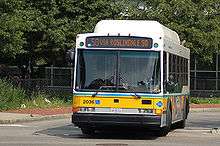

Forest Hills serves as a major bus transfer station; 16 MBTA Bus routes terminate at the station. The 16, 21, 31, 32, and 42 routes which run on Hyde Park Avenue, Washington Street (north of the station), and the Arborway use the lower busway located off Hyde Park Avenue east of the station. The remaining nine routes run on South Street and Washington Street; they use the upper busway west of the station.
The 39 route formerly used loops off New Washington Street built for Green Line "E" Branch trolley service in the 1980s but never used as such. On October 14, 2017, it was permanently rerouted to the upper busway during removal of the Casey Overpass.[10]
- 16 Forest Hills Station - UMass Boston or Andrew Station
- 21 Ashmont Station - Forest Hills Station via Morton Street
- 30 Mattapan Station - Forest Hills Station via Cummings Hwy
- 31 Mattapan Station - Forest Hills Station via Morton Street
- 32 Wolcott Square or Cleary Square - Forest Hills Station via Hyde Park Ave
- 34 Walpole Center or Dedham Line - Forest Hills Station via Washington Street
- 34E Walpole Center or Dedham Line - Forest Hills Station via Washington Street & Dedham Mall
- 35 Dedham Mall - Forest Hills Station via Centre Street
- 36 Charles River Loop or V.A. Hospital - Forest Hills Station via Centre Street
- 37 Baker & Vermont Streets - Forest Hills Station via Centre Street
- 38 Wren Street - Forest Hills Station via Centre & South Streets
- 39 Forest Hills Station - Back Bay Station via Huntington Ave
- 40 Georgetowne - Forest Hills Station via Washington Street
- 42 Forest Hills Station - Dudley Station or Ruggles Station via Washington Street
- 50 Forest Hills Station - Cleary Square via Roslindale Square
- 51 Cleveland Circle - Forest Hills Station via Hancock Village
The 192 Cleary Square - Haymarket via Forest Hills and Copley Square route, a single early-morning trip intended for fare collectors but open to the general public, also stops at Forest Hills.
References
- 1 2 "Ridership and Service Statistics" (PDF) (14th ed.). Massachusetts Bay Transportation Authority. 2014.
- 1 2 Rocheleau, Matt (26 November 2012). "Raising the railroad in Forest Hills". Boston Globe. Retrieved 8 August 2014.
- ↑ Roy, John H. Jr. (2007). A Field Guide to Southern New England Railroad Depots and Freight Houses. Branch Line Press. pp. 210–211. ISBN 9780942147087.
- 1 2 3 4 5 Belcher, Jonathan (22 March 2014). "Changes to Transit Service in the MBTA district" (PDF). NETransit. Retrieved 6 August 2014.
- ↑ Massachusetts Executive Office of Transportation and Construction (22 April 1976). Capital needs developed at the corridor level: core and west (Report). Massachusetts Executive Office of Transportation and Construction. p. 102.
- 1 2 Rocheleau, Matt (3 December 2012). "History time: Southwest Corridor Park". Boston Globe. Retrieved 8 August 2014.
- ↑ "MBTA Forest Hills Station". Cambridge Seven Associates. December 2012. Retrieved 8 August 2014.
- ↑ Ruch, John (26 August 2011). "Trolley comeback killed by court". Jamaica Plain Gazette. Retrieved 19 February 2013.
- ↑ Brelsford, Laura (December 5, 2016). "MBTA System-Wide Accessibility Initiatives: December 2016 Update" (PDF). Massachusetts Bay Transportation Authority Department of System-Wide Accessibility. p. 22.
- ↑ Jessen, Klark (October 10, 2017). "Casey Arborway: MBTA Route 39 Bus Moves to Upper Busway October 14". MassDOT Blog (Press release).
External links
| Wikimedia Commons has media related to Forest Hills station (MBTA). |
- MBTA - Forest Hills
- Photos of this station from world.nycsubway.org
- Cambridge Seven Associates project page
- Station from Google Maps Street View