ABC islands (Lesser Antilles)
ABC Islands
| |
|---|---|
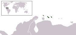 Location of ABC islands (Lesser Antilles) (dark green) | |
| Capitals |
3 Capitals
|
| Languages |
2 languages
|
| Islands | |
| Area | |
• Total | 925 km2 (357 sq mi) |
| Population | |
• 2014 estimate | 275,650 |
• Density | 298/km2 (771.8/sq mi) |
| GDP (PPP) | estimate |
• Total | $5.977 billion |
• Per capita | $21,683 |
| GDP (nominal) | estimate |
• Total | $8.852 billion |
• Per capita | $32,113 |
| HDI |
0.833 very high |
| Currency | |
The ABC islands are the three western-most islands of the Leeward Antilles in the Caribbean Sea that lie north of Falcón State, Venezuela.[1] In order alphabetically they are Aruba, Bonaire, and Curaçao. All three islands are part of the Kingdom of the Netherlands, although they remain outside the European Union. Aruba and Curaçao are autonomous, self-governing constituent countries of the Kingdom of the Netherlands, while Bonaire is a special municipality of the Netherlands proper.
History
According to the disputed letters of Amerigo Vespucci, the ABC islands were first explored by one of Christopher Columbus' captains, Alonso de Ojeda, who landed on Curaçao in 1499.[2] He is said to have called the islands Las islas de los Gigantes or Islands of the Giants due to the native inhabitants, the Caiquetio Indians. The first known European exploration was by Amerigo Vespucci, whose cartographer Juan de la Cosa first described the islands. The first Spanish colonists, unable to find any gold or silver, kidnapped most of the natives to work on plantations on the island of Hispaniola. By 1527 the Spanish had formed a government and established Catholicism on the islands.
In 1634, the Netherlands fought Spain over control of the islands. The Dutch won, and the islands were then administered by the Netherlands. The Dutch West India Company developed the areas, establishing a major port on Curaçao. The abolition of the slave trade in 1863 had a devastating impact on their economies, although the economy revived when oil was discovered in Venezuela during the early 20th century, and the islands became major oil refineries.
From 1815 until 1954 the three islands were known as the Colony of Curaçao and Dependencies. This colony at various times also included Netherlands Suriname and Sint Eustatius and Dependencies. In 1954, the ABC islands became part of the Netherlands Antilles, which gave them political autonomy within the Kingdom of the Netherlands. In 1986 Aruba withdrew from the Netherlands Antilles, becoming a separate country within the kingdom.[3] Upon the dissolution of the Netherlands Antilles on 10 October 2010, Curaçao gained a similar status to Aruba. Bonaire became a special municipality of the Netherlands proper, although it maintains its status of an overseas territory of the European Union.
Geography and climate
The ABC islands are part of the Leeward Antilles, which is the westernmost area of the Lesser Antilles. They lie immediately to the north of Falcón State, Venezuela. Due to their political history, they are sometimes considered to be part of North America along with the other Caribbean islands, although they lie on South America’s geographical plate; the same phenomenon happens with Trinidad and Tobago.
ABC does not indicate the geographical order to each other; from west to east the islands are Aruba, Curação, and Bonaire.
Aruba is a flat island, exposed to the ocean currents. Bonaire and Curação are surrounded by reefs, and so are much more sheltered from the weather. Bonaire and Curação’s reefs are popular tourist destinations.
The ABC Islands have an atypical hot semi-arid climate (Köppen BSh) which is generally very dry as they lie north of the Intertropical Convergence Zone but except in their short rainy season from October to December or January are not exposed to moisture from the northeast trade winds. The rainy season is powerfully influenced by the Southern Oscillation resulting in very high variability.[4] During strong El Niño years like 1911/1912, 1930/1931, 1982/1983 and 1997/1998 annual (fiscal year) rainfall can be less than 200 millimetres or 8 inches, and even under 100 millimetres or 4 inches at Curação in 1911/1912. In contrast, as much as 1,100 millimetres or 43 inches may fall during a strong La Niña year like 1933/1934, 1970/1971, 1988/1989, 1999/2000 or 2010/2011, with the highest monthly totals being over 350 millimetres or 14 inches.
Temperatures in the ABC Islands are uniformly hot, averaging around 28 to 30 °C (82.4 to 86.0 °F) year-round, with high humidity and minima rarely falling below 20 °C or 68 °F even on the mildest mornings, although afternoons rarely top 35 °C or 95 °F.
Environment
Bonaire is known for being a "diving paradise", with ecotourism playing a large part in its economy. The islands have a huge variety of wildlife, including flamingoes and four species of sea turtle.[3]
Demographics
Afro-Caribbean people make up a large proportion of Curaçao and Bonaire's population and Mestizo people make up for the majority of Aruba's population. There has been substantial immigration from Latin America to the islands.
Language
Dutch has been the official language of the islands for most of their history. A unique creole language has developed there known as Papiamentu.[5] Unlike other creole languages, Papiamentu is not decreasing in usage, and was made an official language on 7 March 2007.[6] Papiamentu's origins are debated, a dispute arising on whether it originates from Portuguese or Spanish. It is heavily influenced by Spanish and English.
Politics
Aruba and Curaçao are autonomous countries of the Kingdom of the Netherlands, which have their own parliament and prime minister. Bonaire is a "special municipality" of the Netherlands proper, and subject to Netherlands law.
See also
References
- ↑ Miller, Debra (2005). Caribbean Islands (Lonely Planet) (4th ed.). Lonely Planet. p. 723. ISBN 978-1-74104-055-5.
- ↑ Konetzke, Richard (1963). Entdecker und Eroberer Amerikas ; von Christoph Kolumbus bis Hernán Cortés. Frankfurt am Main: Fischer Bücherei. pp. 54–55.
- 1 2 Sullivan, Lynne M. (2006). Adventure Guide to Aruba, Bonaire & Curaçao. Edison, New Jersey: Hunter Publishing. ISBN 978-1-58843-572-9. Retrieved 2014-06-17.
- ↑ Dewar, Robert E. and Wallis, James R; ‘Geographical patterning in interannual rainfall variability in the tropics and near tropics: An L-moments approach’; in Journal of Climate, 12; pp. 3457–3466
- ↑ Narin, Attila (29 September 2003). "Papiamentu is the local language of the ABC Islands – Aruba, Bonaire, and Curaçao". narin.com. Retrieved 9 July 2010.
- ↑ "Aruba Language". arubavisit.info. Archived from the original on 28 June 2010. Retrieved 9 July 2010.
External links
- Infobonaire.com
- We Share Bonaire - Bonaire tourist information in photos and videos
- ABC Islands Compared - a travel essay by Attila Narin
- Map of the region
- Map of the islands