Épaux-Bézu
| Épaux-Bézu | |
|---|---|
| Commune | |
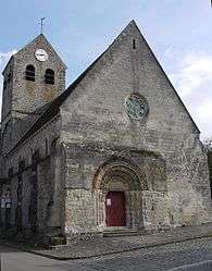 The church of Épaux-Bézu | |
 Épaux-Bézu Location within Hauts-de-France region  Épaux-Bézu | |
| Coordinates: 49°06′33″N 3°20′54″E / 49.1092°N 3.3483°ECoordinates: 49°06′33″N 3°20′54″E / 49.1092°N 3.3483°E | |
| Country | France |
| Region | Hauts-de-France |
| Department | Aisne |
| Arrondissement | Château-Thierry |
| Canton | Château-Thierry |
| Intercommunality | Château Thierry |
| Government | |
| • Mayor (2008–2014) | Étienne Hay |
| Area1 | 19.5 km2 (7.5 sq mi) |
| Population (2008)2 | 569 |
| • Density | 29/km2 (76/sq mi) |
| Time zone | UTC+1 (CET) |
| • Summer (DST) | UTC+2 (CEST) |
| INSEE/Postal code | 02279 /02400 |
| Elevation |
100–217 m (328–712 ft) (avg. 125 m or 410 ft) |
|
1 French Land Register data, which excludes lakes, ponds, glaciers > 1 km2 (0.386 sq mi or 247 acres) and river estuaries. 2 Population without double counting: residents of multiple communes (e.g., students and military personnel) only counted once. | |
Épaux-Bézu is a commune in the Aisne department in Hauts-de-France in northern France.
Population
| Historical population | ||
|---|---|---|
| Year | Pop. | ±% |
| 1962 | 333 | — |
| 1968 | 316 | −5.1% |
| 1975 | 276 | −12.7% |
| 1982 | 334 | +21.0% |
| 1990 | 433 | +29.6% |
| 1999 | 534 | +23.3% |
| 2008 | 569 | +6.6% |
Geography
Épaux-Bézu is located about ten kilometers north of Château-Thierry, near the A4 motorway and the D1.
See also
References
| Wikimedia Commons has media related to Épaux-Bézu. |
This article is issued from
Wikipedia.
The text is licensed under Creative Commons - Attribution - Sharealike.
Additional terms may apply for the media files.