Stryn
| Stryn kommune | |||
|---|---|---|---|
| Municipality | |||
 View of Stryn | |||
| |||
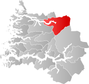 Stryn within Sogn og Fjordane | |||
| Coordinates: 61°50′19″N 06°51′46″E / 61.83861°N 6.86278°ECoordinates: 61°50′19″N 06°51′46″E / 61.83861°N 6.86278°E | |||
| Country | Norway | ||
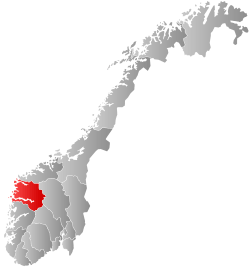
| County | Sogn og Fjordane | ||
| District | Nordfjord | ||
| Administrative centre | Stryn | ||
| Government | |||
| • Mayor (2011) | Sven Flo (H) | ||
| Area | |||
| • Total | 1,377.21 km2 (531.74 sq mi) | ||
| • Land | 1,321.16 km2 (510.10 sq mi) | ||
| • Water | 56.05 km2 (21.64 sq mi) | ||
| Area rank | #63 in Norway | ||
| Population (2017) | |||
| • Total | 7,218 | ||
| • Rank | #147 in Norway | ||
| • Density | 5.5/km2 (14/sq mi) | ||
| • Change (10 years) | 7.6% | ||
| Demonym(s) | Stryning[1] | ||
| Time zone | UTC+01:00 (CET) | ||
| • Summer (DST) | UTC+02:00 (CEST) | ||
| ISO 3166 code | NO-1449 | ||
| Official language form | Nynorsk | ||
| Website |
www | ||

Stryn is a municipality in the county of Sogn og Fjordane, Norway. It is located in the traditional district of Nordfjord. The administrative center of the municipality is the village of Stryn. The municipality is located along the innermost part of the Nordfjorden. Some of the main villages in Stryn include Loen, Innvik, Utvik, Randabygda, Olden, and Flo.

Farming, forestry, fruit growing, animal breeding for furs, small manufacturing industries, tourism, and the service trades provide the main occupations. The wide river Stryneelva enters the village of Stryn from the east after meandering through the fertile Stryn Valley, from the large lake Oppstrynsvatn. The Jostedalsbreen National Park Centre is situated on the shore of this lake. At the east end of the lake, the road enters the narrower Hjelledalen and shortly zigzags up some 300 metres (980 ft) to Ospeli and the entrance of the first of the three tunnels of the mountain highway (Riksvei 15) leading to Geiranger and Grotli.
Stryn is known for its all year glacier skiing at Stryn Sommerski. It is also the home of the footballer-brothers Tore André Flo, Jarle Flo and Jostein Flo, who grew up in the village of Stryn, as well as their footballing-cousin Håvard Flo who is from the village of Flo.
The 1,377-square-kilometre (532 sq mi) municipality is the 63rd largest by area out of the 422 municipalities in Norway. Stryn is the 147th most populous municipality in Norway with a population of 7,218. The municipality's population density is 5.5 inhabitants per square kilometre (14/sq mi) and its population has increased by 7.6% over the last decade.[2]
General information
Innvik was established as a municipality on 1 January 1838 (see formannskapsdistrikt). The original municipality was identical to the Innvik parish (prestegjeld) with the sub-parishes (sokn) of Oppstryn, Nedstryn, Loen, Olden, Innvik, and Utvik. In 1843, the sub-parishes of Loen, Oppstryn, and Nedstryn were separated from the municipality of Innvik and became a separate municipality named Stryn. The population of Stryn at this time was 2,401. On 10 January 1922, the area of Raksgrenda was transferred from Innvik to Stryn. The population in this area was 120 at that time.[3]
During the 1960s, there were many municipal mergers across Norway due to the work of the Schei Committee. On 1 January 1965, a merger took place combining the following areas into a new Stryn municipality:
- the municipality of Innvik (population: 3,003)
- the municipality of Stryn (population: 2,982)
- everything east of Navelsaker and Holmøyvik in Hornindal Municipality (population: 1,184)
- Hoplandsgrenda in the municipality of Gloppen (population: 42)
Initially, this new municipality of Stryn had a population of 7,211.[3]
On 1 January 1977, the parts of Hornindal municipality that were merged with Stryn in 1965 were transferred back to the newly re-constituted Hornindal municipality. The population of Stryn was reduced by 1,202 in this transaction.[3]
Name
The name (Old Norse: Strjónar) originally (probably) belonged to the river of Stryneelva. The name is derived from strjónn which means "(strong) stream".[4]
Coat of arms
The coat-of-arms is from modern times; they were granted on 11 December 1987. The arms are green with a gold-colored linden (tilia) branch with four leaves. The linden was chosen to represent the vast deciduous forests in the region and the four leaves were chosen to represent the four main village areas along the fjord.[5]
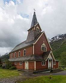
Churches
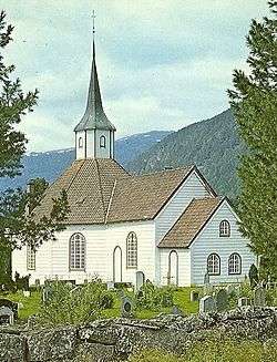
The Church of Norway has eight parishes (sokn) within the municipality of Stryn. It is part of the Nordfjord deanery in the Diocese of Bjørgvin. [6]
| Parish (Sokn) | Church Name | Location of the Church | Year Built |
|---|---|---|---|
| Oppstryn | Oppstryn Church | Oppstryn | 1863 |
| Nedstryn | Nedstryn Church | Nedstryn | 1859 |
| Loen | Loen Church | Loen | 1838 |
| Innvik | Innvik Church | Innvik | 1822 |
| Utvik | Utvik Church | Utvik | 1840 |
| Olden | Olden Church | Olden | 1934 |
| Old Olden Church | 1772 | ||
| Ljosheim Chapel | Mykløy in Oldedalen | 1924 | |
| Randabygda | Randabygd Church | Randabygda | 1916 |
| Nordsida | Nordsida Church | Roset | 1973 |
Government
All municipalities in Norway, including Stryn, are responsible for primary education (through 10th grade), outpatient health services, senior citizen services, unemployment and other social services, zoning, economic development, and municipal roads. The municipality is governed by a municipal council of elected representatives, which in turn elect a mayor.
Municipal council
The municipal council (Kommunestyre) of Stryn is made up of 25 representatives that are elected to four year terms. Currently, the party breakdown is as follows:[7]
| Party Name | Name in Norwegian | Number of representatives | |
|---|---|---|---|
| Labour Party | Arbeiderpartiet | 3 | |
| Progress Party | Framstegspartiet | 1 | |
| Conservative Party | Høgre | 10 | |
| Christian Democratic Party | Kristelig Folkeparti | 2 | |
| Centre Party | Senterpartiet | 7 | |
| Liberal Party | Venstre | 2 | |
| Total number of members: | 25 | ||
Mayor
The mayor (ordførar) of a municipality in Norway is a representative of the majority party of the municipal council who is elected to lead the council. Sven Flo of the Conservative Party (Høyre) was elected as mayor in 2011 and was re-elected in 2015.[8]
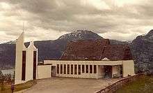
Geography
.jpg)
.jpg)


Location
Stryn is located on the northern border of Sogn og Fjordane county. To the north, Stryn is bordered by the municicaplities of Hornindal (Sogn og Fjordane county) and Stranda (in Møre og Romsdal county), to the east is Skjåk (in Oppland county), to the southeast is Luster, to the southwest is Jølster, and to the west is Gloppen and Eid.
Nature
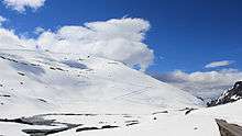
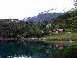
Stryn is known for its scenery, glaciers and the mountains running into the mirroring fjords and lakes. The glacier Briksdalsbreen lies in the Oldedalen valley. The Stryn area also has a number of other valley glaciers including Tindefjellbreen, Tystigsbreen, and Myklebustbreen. Most of the valley glaciers in Stryn are originating from the great Jostedal glacier (Jostedalsbreen) between the Nordfjord and Sogn areas.
Ramnefjellsfossen, the third highest free-falling waterfall in the world, is located in the municipality. Stryn also has the largest linden forest in Northern Europe. The largest lakes are Oppstrynsvatn, Lovatnet, and Oldevatnet. The mountains Skåla, Lodalskåpa, and Høgstre Breakulen are all located in Stryn.
Jostedal Glacier National Park
The Jostedalsbreen National Park has an area of approximately 1,310 square kilometres (510 sq mi). Flora and fauna area is situated between the fjord and glacier. The museum Jostedalsbreen nasjonalparksenter is located in Oppstryn.
Briksdal glacier
Visitors from all over the world come to see the Briksdalsbreen glacier outlet, which is situated amid waterfalls and high peaks. Briksdal glacier is a part of the Jostedal glacier ice field, which is the largest glacier on the European mainland. The highest point of the glacier lies at 1,950 metres (6,400 ft) above sea level and in some places it measures 400 metres (1,300 ft) in depth. It is located at the end of the Oldedalen valley.
Lodalen–Kjenndalen
On two occasions, large rockslides from Ramnefjellet hit the lake below. The resulting flood wave wiped out the settlements of Nesdal and Bødal, killing 135 people.
Wildlife
There are many bird species in this area including the golden eagle (Aquila chrysaetos), rough-legged buzzard (Buteo lagopus), and the white-backed woodpecker (Dendrocopus leucotos). Some of the larger mammals that live in this region are red deer (Cervus elaphus), wolverines (Gulo gulo), and lynxes (Lynx lynx).
National Tourist Route
The Gamle Strynefjellsvegen is a National Tourist Route (Fylkesvei 258). It goes from Grotli (Skjåk municipality in Oppland county) to Videseter, where a waterfall is, and on to the village of Stryn (Sogn og Fjordane county).
Attractions
Stryn Center
The village of Stryn, a busy and developing small village at the tip of the most northernly of the three short branches at the inner end of Nordfjorden, is the local government and shopping centre for a large community and the junction of roads which connect inner Nordfjord with the rest of Norway.
Oldedalen Valley
The southernmost of the three short branches at the inner end of Nordfjorden terminates at the village of Olden from which a lovely valley, Oldedalen, goes due south for about 20 kilometres (12 mi) between slopes rising sharply to more than 1,700 metres (5,600 ft) to the edge of the Jostedals glacier.
Olden has two churches. The Old Olden Church in the village, was built in 1759 on the site of a Stave church dating from around 1300. Its pews, doors, and jambs are made from timbers of the Stave church. The "new" Olden Church, a short distance along the valley, was built in 1934 so that the old church could be preserved.
Loen and Lodalen Valley
The Loen Skylift is located in Loen, and Hotel Alexandra is a popular tourist retreat. Loen Valley (Lodalen) is a popular attraction, and Kjenndal Glacier is located at the end of the valley (branch of the Jostedal Glacier). Much of the upper Loen valley was devastated from two rockfall slides (one in 1905 and one in 1936) that created huge waves that swept with them most of the houses and vegetation. A total of 135 people were killed in these two incidents.
Innvik and Utvik
On the southern shore of the Nordfjorden, between Hildaneset and Utvikfjellet, lie the villages of Innvik and Utvik, in the area known as Vikane. The main road (Rv 60) skirts the fjord past Innvik and ascends from Utvik to Utvikfjellet mountain. At Hildaneset, beside the main road, there is a sculpture of Mr. Singer. Mr Singer financed the building of the road.
Skiing
Stryn Sommerski is one of Norway's best known skiing facilities. It offers excellent skiing conditions in the summer, with lifts and tracks for all types of skiing, including Cross-country skiing, Alpine skiing, Telemark skiing, and snowboarding.
References
- ↑ "Navn på steder og personer: Innbyggjarnamn" (in Norwegian). Språkrådet. Retrieved 2015-12-01.
- ↑ Statistisk sentralbyrå (2017). "Table: 06913: Population 1 January and population changes during the calendar year (M)" (in Norwegian). Retrieved 2017-10-22.
- 1 2 3 Jukvam, Dag (1999). "Historisk oversikt over endringer i kommune- og fylkesinndelingen" (PDF) (in Norwegian). Statistics Norway.
- ↑ Rygh, Oluf (1919). Norske gaardnavne: Nordre Bergenhus amt (in Norwegian) (12 ed.). Kristiania, Norge: W. C. Fabritius & sønners bogtrikkeri. p. 511.
- ↑ "Civic heraldry of Norway - Norske Kommunevåpen". Heraldry of the World. Retrieved 2017-10-22.
- ↑ "Kyrkjer i Stryn" (in Norwegian). NRK.no. 27 May 2002. Retrieved 29 June 2008.
- ↑ "Table: 04813: Members of the local councils, by party/electoral list at the Municipal Council election (M)" (in Norwegian). Statistics Norway. 2015.
- ↑ "Ordføraren informerer" (in Norwegian). Stryn Kommune. Retrieved 29 June 2008.
External links
| Wikimedia Commons has media related to Stryn. |
| Wikivoyage has a travel guide for Stryn. |
- Municipal fact sheet from Statistics Norway (in Norwegian)
- Official Website of Stryn (in Norwegian)
- Official travel guide to Stryn
- Stryn summer skiing
- NRK: Stryn Kommune (in Norwegian)
- Gamle Strynefjellsvegen