Hornindal
| Hornindal kommune | |||
|---|---|---|---|
| Municipality | |||
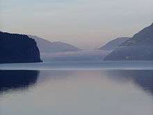
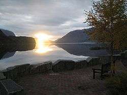 View of the lake Hornindalsvatnet | |||
| |||
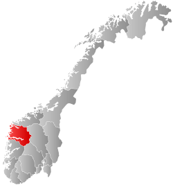
 Hornindal within Sogn og Fjordane | |||
| Coordinates: 61°59′55″N 06°35′03″E / 61.99861°N 6.58417°ECoordinates: 61°59′55″N 06°35′03″E / 61.99861°N 6.58417°E | |||
| Country | Norway | ||
| County | Sogn og Fjordane | ||
| District | Nordfjord | ||
| Administrative centre | Grodås | ||
| Government | |||
| • Mayor (2015) | Stig Olav Lødemel (H) | ||
| Area | |||
| • Total | 191.60 km2 (73.98 sq mi) | ||
| • Land | 178.44 km2 (68.90 sq mi) | ||
| • Water | 13.16 km2 (5.08 sq mi) | ||
| Area rank | #334 in Norway | ||
| Population (2017) | |||
| • Total | 1,198 | ||
| • Rank | #381 in Norway | ||
| • Density | 6.7/km2 (17/sq mi) | ||
| • Change (10 years) | -0.2% | ||
| Demonym(s) | Horndøl[1] | ||
| Time zone | UTC+01:00 (CET) | ||
| • Summer (DST) | UTC+02:00 (CEST) | ||
| ISO 3166 code | NO-1444 | ||
| Official language form | Nynorsk | ||
| Website |
www | ||

Hornindal is a municipality in the county of Sogn og Fjordane, Norway. It is located in the traditional district of Nordfjord. The administrative centre of the municipality is the village of Grodås. The municipality sits at the eastern end of the lake Hornindalsvatnet, the deepest lake in Northern Europe. The rest of the lake lies inside neighboring Eid Municipality.
The European route E39 highway is runs through Hornindal Municipality as it makes its route along the western coast of Norway. The Kviven Tunnel was completed in 2012 as part of the new E39 route connecting Hornindal to Volda Municipality in Møre og Romsdal county to the north. The tunnel was constructed to avoid the ferry crossing over the Voldsfjorden and it shortened the distance from Hornindal to Volda significantly.
The 192-square-kilometre (74 sq mi) municipality is the 334th largest by area out of the 422 municipalities in Norway. Hornindal is the 381st most-populous municipality in Norway, with a population of 1,198. The municipality's population density is 6.7 inhabitants per square kilometre (17/sq mi) and its population has decreased by 0.2% over the last decade.[2]
General information

Since ancient times, Hornindal was a sub-parish (sokn) of Eid prestegjeld (see formannskapsdistrikt). In 1865, Hornindal became a parish of its own and then two years later, on 1 January 1867, Hornindal was established as a separate municipality. At this time, Hornindal had a population of 1,612.[3]
During the 1960s, there were many municipal mergers across Norway due to the work of the Schei Committee. On 1 January 1965, the municipality of Hornindal was dissolved and it was divided between the neighboring municipalities of Eid and Stryn. Navelsaker and Holmøyvik and all of Hornindal west of there (population: 310) was transferred to Eid, and the 1,184 residents to the east of those areas went to Stryn. This, however, was not long-lasting. On 1 January 1977, the area of the old municipality of Hornindal was separated from Stryn and recreated as a separate municipality once again. The portions of Hornindal that were moved to Eid in 1964 remained there. The new Hornindal municipality had a population of 1,202.[3]
On 1 January 2020, Hornindal (in Sogn og Fjordane county) will merge with the neighboring municipality of Volda and join Møre og Romsdal county.[4]
Name
The municipality (originally the parish) is named after the old farm called Horne (Old Norse: Hornvin), since the first church (Hornindal Church) was built there. The first element is horn which means "horn" (here referring to a pointed mountain behind the farm) and the last element is vin which means "meadow" or "pasture". So the meaning of the compounded name Hornindal is "the valley/dale of Horne".[5]
Coat of arms
The coat of arms is from modern times; they were granted on 7 August 1987. They were designed by Petter Eide. It shows three silver blades of scythes on a blue background. Historically, farming and blacksmithing were vital industries in Hornindal. At one point, there were as many as 200 blacksmiths in the area. There was also a rich tradition of making handmade scythes and this was very symbolized by putting scythes on the coat-of-arms.[6][7]
Churches
The Church of Norway has one parish (sokn) within the municipality of Hornindal. It is part of the Nordfjord deanery in the Diocese of Bjørgvin.
| Parish (Sokn) | Church Name | Location of the Church | Year Built |
|---|---|---|---|
| Hornindal | Hornindal Church | Grodås | 1856 |
Government
All municipalities in Norway, including Hornindal, are responsible for primary education (through 10th grade), outpatient health services, senior-citizen services, unemployment and other social services, zoning, economic development, and municipal roads. The municipality is governed by a municipal council of elected representatives, which in turn elect a mayor.
Municipal council
The municipal council (Kommunestyre) of Hornindal is made up of 17 representatives that are elected to four-year terms. Currently, the party breakdown is as follows:[8]
| Party Name | Name in Norwegian | Number of representatives | |
|---|---|---|---|
| Labour Party | Arbeiderpartiet | 4 | |
| Conservative Party | Høgre | 5 | |
| Centre Party | Senterpartiet | 6 | |
| Liberal Party | Venstre | 2 | |
| Total number of members: | 17 | ||
Mayor
The mayor (ordførar) of a municipality in Norway is a representative of the majority party of the municipal council who is elected to lead the council. Stig Olav Lødemel of the Conservative Party was elected mayor for the 2015–2019 term.[9]
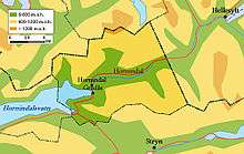
Geography

Location
Hornindal is located on the northern border of Sogn og Fjordane county. Hornindal is bordered to the west by the municipality of Eid, to the south by Stryn, to the east by Stranda (in Møre og Romsdal county), and to the north by Ørsta and Volda (both in Møre og Romsdal county).
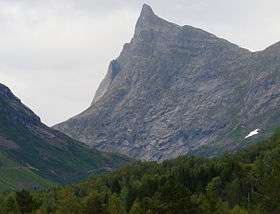
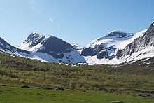
Mountains
- Hornindalsrokken mountain (1,495 metres or 4,905 feet)
- Gulkoppen mountain (1,304 metres or 4,278 feet)
- Middagsfjellet (903 metres or 2,963 feet)
Attractions
Hornindalsvatnet
The Hornindalsvatnet lake is the deepest lake in Europe at 514 metres (1,686 ft) deep. None of the glacier streams run out into the lake and this has resulted in one of Europe's clearest lakes.[10]
Anders Svor Museum
Anders Svor was born in 1864 on the Svor Farm in Hornindal. At the age of 21 he left for Denmark where he enrolled at the Copenhagen Academy of Art. He later participated in many art exhibitions in Kristiania, Copenhagen, Paris, and Chicago. The Anders Svor Museum was opened in 1953 and features 450 of his works. His art is characterised by simple, clean lines, and deep authenticity.[11]
Famous people
- Frode Grodås, (born 1964), footballer
- Bjørn Lødemel (born 1958), politician
- Brita Lund, (1886–1966), artist
- Anders Svor, (1864–1929), sculptor
- Anders Fannemel, (born 1991), ski jumper
References
- ↑ "Navn på steder og personer: Innbyggjarnamn" (in Norwegian). Språkrådet. Retrieved 2015-12-01.
- ↑ Statistisk sentralbyrå (2017). "Table: 06913: Population 1 January and population changes during the calendar year (M)" (in Norwegian). Retrieved 2017-10-22.
- 1 2 Juvkam, Dag (1999). "Historisk oversikt over endringer i kommune- og fylkesinndelingen" (PDF) (in Norwegian). Statistics Norway.
- ↑ "Nye Volda" (in Norwegian). Retrieved 2017-10-22.
- ↑ Rygh, Oluf (1919). Norske gaardnavne: Nordre Bergenhus amt (in Norwegian) (12 ed.). Kristiania, Norge: W. C. Fabritius & sønners bogtrikkeri. pp. 448–449.
- ↑ Tvinnereim, Jarle (24 April 2008). "Kommunevåpenet til Hornindal" (in Norwegian). Archived from the original on 26 February 2012. Retrieved 21 July 2008.
- ↑ "Civic heraldry of Norway – Norske Kommunevåpen". Heraldry of the World. Retrieved 2017-10-22.
- ↑ "Table: 04813: Members of the local councils, by party/electoral list at the Municipal Council election (M)" (in Norwegian). Statistics Norway. 2015.
- ↑ Hornindal Kommune. "Presentasjon av ordførar Stig Olav Lødemel" (in Norwegian). Retrieved 2017-10-22.
- ↑ "Hornindal Municipality in Norway". GoNorway.com. Retrieved 21 July 2008.
- ↑ "Anders Svor Museum, Hornindal". 13 August 2007. Retrieved 21 July 2008.
External links
- Municipal fact sheet from Statistics Norway (in Norwegian)
- Official website of Hornindal (in Norwegian)
- NRK: Hornindal (in Norwegian)
- Webcam in Hornindal (in Norwegian)