Leikanger
| Leikanger kommune | |||
|---|---|---|---|
| Municipality | |||
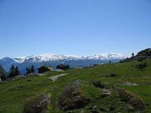
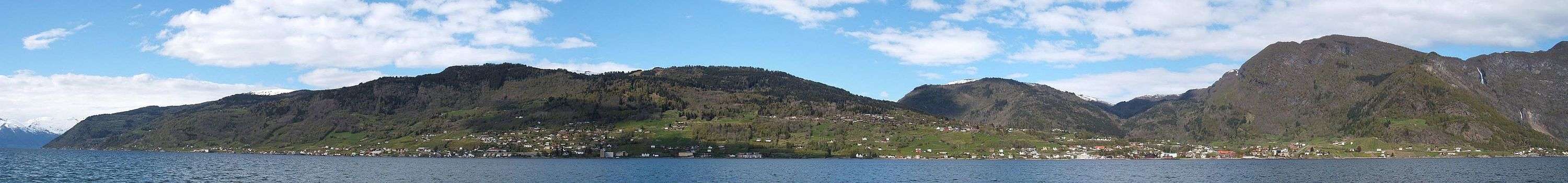
 View of Hermansverk | |||
| |||
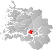 Leikanger within Sogn og Fjordane | |||
| Coordinates: 61°13′51″N 06°47′23″E / 61.23083°N 6.78972°ECoordinates: 61°13′51″N 06°47′23″E / 61.23083°N 6.78972°E | |||
| Country | Norway | ||
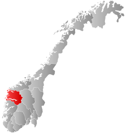
| County | Sogn og Fjordane | ||
| District | Sogn | ||
| Administrative centre | Hermansverk | ||
| Government | |||
| • Mayor (2015) | Jon Håkon Odd (Ap) | ||
| Area | |||
| • Total | 180.10 km2 (69.54 sq mi) | ||
| • Land | 177.44 km2 (68.51 sq mi) | ||
| • Water | 2.66 km2 (1.03 sq mi) | ||
| Area rank | #342 in Norway | ||
| Population (2017) | |||
| • Total | 2,332 | ||
| • Rank | #305 in Norway | ||
| • Density | 13.1/km2 (34/sq mi) | ||
| • Change (10 years) | 6.0% | ||
| Demonym(s) | Systrending[1] | ||
| Time zone | UTC+01:00 (CET) | ||
| • Summer (DST) | UTC+02:00 (CEST) | ||
| ISO 3166 code | NO-1419 | ||
| Official language form | Nynorsk | ||
| Website |
www | ||
Leikanger [læiˈkɑŋːər] (![]()
The Leikanger/Hermansverk urban area has 2,110 inhabitants (2016), about 90% of the municipal population.[2] This urban area is often called Systrond, which is why a person from Leikanger is often called Systrending.
The 180-square-kilometre (69 sq mi) municipality is the 342nd largest by area out of the 422 municipalities in Norway. Leikanger is the 305th most populous municipality in Norway with a population of 2,332. The municipality's population density is 13.1 inhabitants per square kilometre (34/sq mi) and its population has increased by 6% over the last decade.[3]
General information


Leikanger was established as a municipality on 1 January 1838 (see formannskapsdistrikt). The original municipality was large and it was identical to the old Leikanger parish (prestegjeld) with the six sub-parishes (sokn) of Leikanger, Fresvik, Rinde, Vangsnes, Tjugum, and Mundal. In 1849, the sub-parishes of Vangsnes, Tjugum, and Mundal were transferred into the newly created Balestrand parish (prestegjeld). The new parish was separated from Leikanger municipality in 1850 to form the new Balestrand municipality. This split left Leikanger with 2,368 residents.[4]
During the 1960s, there were many municipal mergers across Norway due to the work of the Schei Committee. On 1 January 1964, the Hella-Eitorn area (population: 31) was transferred from Balestrand back to Leikanger. Also, the Tingstad area (population: 5) was transferred to neighboring Sogndal municipality. These changes left Leikanger with 2,680 residents. On 1 January 1992, the sub-parishes of Leikanger lying south of the Sognefjorden, including Feios and Fresvik (total population: 572) were transferred to the municipality of Vik. This move left Leikanger with only one sub-parish: Leikanger.[4][5]
On 1 January 2020, the three neighboring municipalities of Balestrand, Leikanger, and Sogndal will merge to form a much larger municipality called Sogndal.[6]
Name
The municipality (originally the parish) is named after the old farm Leikanger (Old Norse: Leikvangir), since the first Leikanger Church was built there. The first element is leikr which means "sports" or "athletics" and the last element is the plural form of vangr which means "meadow". Prior to 1889, the name was written Lekanger.[7]
Coat-of-arms
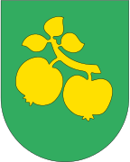
The coat-of-arms were granted on 5 September 1963. The arms are green with a yellow-colored apple tree branch with two apples and three leaves attached. The apple tree branch is a symbol for the many orchards in the municipality and thus for the local economy. The three leaves symbolised the three parishes that used to make up the municipality (before two of them were transferred to Vik in 1992).[8]
Churches
The Church of Norway has one parish (sokn) within the municipality of Leikanger. It is part of the Indre Sogn deanery in the Diocese of Bjørgvin.
| Parish (Sokn) | Church Name | Location of the Church | Year Built |
|---|---|---|---|
| Leikanger | Leikanger Church | Leikanger | 1166 |
Government

All municipalities in Norway, including Leikanger, are responsible for primary education (through 10th grade), outpatient health services, senior citizen services, unemployment and other social services, zoning, economic development, and municipal roads. The municipality is governed by a municipal council of elected representatives, which in turn elect a mayor.
Municipal council
The municipal council (Kommunestyre) of Leikanger is made up of 17 representatives that are elected to four year terms. Currently, the party breakdown is as follows:[9]
| Party Name | Name in Norwegian | Number of representatives | |
|---|---|---|---|
| Labour Party | Arbeiderpartiet | 7 | |
| Conservative Party | Høgre | 1 | |
| Centre Party | Senterpartiet | 5 | |
| Socialist Left Party | Sosialistisk Venstreparti | 1 | |
| Liberal Party | Venstre | 3 | |
| Total number of members: | 17 | ||
Mayor
The mayor (ordførar) of a municipality in Norway is a representative of the municipal council who is elected either by the majority of the council. Jon Håkon Odd of the Labour Party was elected mayor for the 2015-2019 term.
Geography
Leikanger is located on the north side of the Sognefjorden and to the east of the Fjærlandsfjorden. It is bordered on the north and east by the municipality of Sogndal, on the west by Balestrand, and on the south (across the Sognefjorden) by Vik.
Buildings and structures
East of Leikanger, there are the Sognefjord Spans, three powerline spans with length over 4 kilometres (2.5 mi), which are currently the 2nd, 3rd, and 4th longest spans in the world. In 1955, the first Sognefjord Span was built near Leikanger. It was the longest span in the world from 1955 until 1997.
Sister cities/Twin towns
Leikanger has sister city agreements with the following places:
References
- ↑ "Navn på steder og personer: Innbyggjarnamn" (in Norwegian). Språkrådet. Retrieved 2015-12-01.
- ↑ Statistisk sentralbyrå (1 January 2016). "Urban settlements. Population and area, by municipality".
- ↑ Statistisk sentralbyrå (2017). "Table: 06913: Population 1 January and population changes during the calendar year (M)" (in Norwegian). Retrieved 2017-10-22.
- 1 2 Jukvam, Dag (1999). "Historisk oversikt over endringer i kommune- og fylkesinndelingen" (PDF) (in Norwegian). Statistics Norway.
- ↑ Natvik, Oddvar (9 February 2005). "Some historical data on the 26 Kommunes". Archived from the original on 13 June 2008. Retrieved 23 June 2008.
- ↑ "Nye Sogndal kommune" (in Norwegian). Retrieved 2017-10-22.
- ↑ Rygh, Oluf (1919). Norske gaardnavne: Nordre Bergenhus amt (in Norwegian) (12 ed.). Kristiania, Norge: W. C. Fabritius & sønners bogtrikkeri. p. 124.
- ↑ "Civic heraldry of Norway - Norske Kommunevåpen". Heraldry of the World. Retrieved 2017-10-22.
- ↑ "Table: 04813: Members of the local councils, by party/electoral list at the Municipal Council election (M)" (in Norwegian). Statistics Norway. 2015.
External links
| Wikimedia Commons has media related to Leikanger. |
- Municipal fact sheet from Statistics Norway (in Norwegian)
- Official Leikanger municipality website (in Norwegian)
- NRK: Leikanger (in Norwegian)