East Fork High Rock Canyon Wilderness
| East Fork High Rock Canyon | |
| Wilderness | |
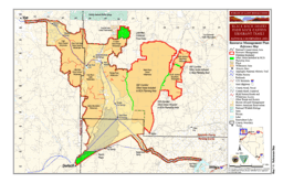 BLM map of the Black Rock-High Rock NCA and 10 wilderness areas including East Fork High Rock Canyon Wilderness | |
| Country | United States |
|---|---|
| State | Nevada |
| Region | Black Rock Desert |
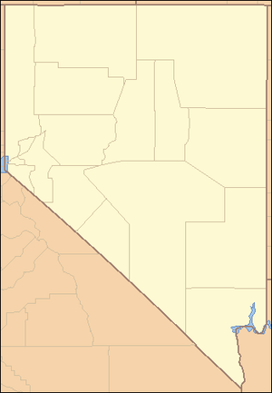
| Location | Washoe County / Humboldt County |
| - elevation | 1,738 m (5,702 ft) |
| - coordinates | 41°25′55.631″N 119°21′21.710″W / 41.43211972°N 119.35603056°WCoordinates: 41°25′55.631″N 119°21′21.710″W / 41.43211972°N 119.35603056°W |
| Founded | 2000 |
| Date | December 21 |
| Management | Bureau of Land Management |
| For public | Open to the public. BLM wilderness rules apply – mechanized travel prohibited. |
| Timezone | Pacific (UTC-8) |
| - summer (DST) | PDT (UTC-7) |
| Topo map | USGS Yellow Hills East |
The East Fork High Rock Canyon Wilderness is a U S Wilderness Area in Nevada under the Bureau of Land Management. It is located on the northeast side of High Rock Canyon but does not include the 4x4 trail inside High Rock Canyon nor a 4x4 trail to the Yellow Hills.[1][2]
See also
References
- 1 2 3 "East Fork High Rock Canyon Wilderness". Geographic Names Information System. United States Geological Survey. Retrieved 2009-05-04.
- ↑ "BLM Black Rock Desert-High Rock Canyon Emigrant Trails National Conservation Area". Bureau of Land Management. Archived from the original on 2007-07-03. Retrieved 2007-12-30.
External links
This article is issued from
Wikipedia.
The text is licensed under Creative Commons - Attribution - Sharealike.
Additional terms may apply for the media files.