Seven Troughs Range
| Seven Troughs Range | |
|---|---|
| Highest point | |
| Peak | Seven Trough Peak |
| Elevation | 2,376 m (7,795 ft) |
| Coordinates | 40°31′5″N 118°49′19″W / 40.51806°N 118.82194°WCoordinates: 40°31′5″N 118°49′19″W / 40.51806°N 118.82194°W |
| Dimensions | |
| Length | 19 mi (31 km) NNE-SSW |
| Width | 5 mi (8.0 km) E-W |
| Area | 140 sq mi (360 km2) |
| Geography | |
| Country | United States |
| State | Nevada |
| District | Pershing County |
| Topo map |
USGS Seven Troughs, Juniper Flat and Rocky Canyon 7.5 min. quads |

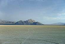
The Seven Troughs Range is a mountain range in western Pershing County, Nevada.[1]
The name is derived from a series of seven stock watering troughs placed below a set springs.[2][3]
Neighboring features include:[4][5]
- the Kama and Antelope ranges to the north,
- the Majuba Mountains to the northeast,
- Sage Valley and Trinity Range to the southeast with Lovelock beyond;
- Granite Springs Valley to the south,
- the Sahwave Mountains and small Blue Wing Mountains to the southwest;
- Kumiva Valley and the Selenite Range to the west and
- Black Rock Desert to the northwest.
Mining camps
Along the southeast margin of the range above Sage Valley are several ghost towns dating from the early 1900s, which served the gold mining activity in the canyons. Running from northeast to southwest are the sites of Ferrell, Mazuma, Tunnel Camp and Vernon.[6][7]
References
- 1 2 "Seven Troughs Range". Geographic Names Information System. United States Geological Survey. Retrieved 2009-05-04.
- ↑ Carlson, Helen S. (1974). Nevada Place Names: A Geographical Dictionary. University of Nevada Press. p. 213. ISBN 9780874170948. Retrieved 2 Mar 2014.
- ↑ Federal Writers' Project (1941). Origin of Place Names: Nevada (PDF). W.P.A. p. 66.
- ↑ Lovelock, Nevada, 30x60 minute quadrangle, USGS, 1984
- ↑ Eugene Mts., Nevada, 30x60 minute quadrangle, USGS, 1985
- ↑ Seven Troughs, Nevada, 7.5 minute quad., USGS, 1981
- ↑ Rocky Canyon, Nevada, 7.5 minute quad., USGS, 1982
This article is issued from
Wikipedia.
The text is licensed under Creative Commons - Attribution - Sharealike.
Additional terms may apply for the media files.