Lahontan State Recreation Area
| Lahontan State Recreation Area | |
| Nevada State Park | |
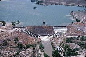 Lahontan Dam on the Carson River | |
| Country | |
|---|---|
| State | |
| Counties | Churchill, Lyon |
| Nearest city | Fallon |
| Elevation | 4,258 ft (1,298 m) [1] |
| Coordinates | 39°24′03″N 119°07′33″W / 39.40083°N 119.12583°WCoordinates: 39°24′03″N 119°07′33″W / 39.40083°N 119.12583°W [1] |
| Area | 28,892.30 acres (11,692 ha) [2] |
| Established | 1971 |
| Management | Nevada Division of State Parks |
 Location in Nevada | |
| Website: Lahontan State Recreation Area | |
Lahontan State Recreation Area is a public recreation area surrounding Lake Lahontan, an impoundment of the Carson River, located approximately 18 miles (29 km) west of Fallon, Nevada.[3] The reservoir is nearly 17 miles (27 km) long and features 69 miles (111 km) of shoreline and 10,000 acres (4,000 ha) of water when full.[4] Most of the park lies below 4,000 feet (1,200 m) in elevation and is dominated by high desert sagebrush; cottonwoods and willow trees can be found along the shore of the lake. Primary access points to the park are along U.S. Route 50 near the Lahontan Dam and off U.S. Route 95 in the town of Silver Springs.[3] A corridor known as Carson River Ranches connects Lahontan with Fort Churchill State Historic Park.
History
Following passage of the Newlands Reclamation Act of 1902, the Lahontan Dam was constructed along the Carson River between Fallon and Carson City. The dam, measuring 162 feet (49 m) high and 1,700 feet (520 m) long, was completed in 1915. The reservoir was named after ancient Lake Lahontan which covered much of Nevada during the ice age. Submerged beneath the water were parts of stagecoach routes which existed during the 1800s including Williams Station, the scene of the Battle of Williams Station, a minor skirmish during the Paiute War.
Originally operated by Churchill and Lyon counties, Lahontan became a state-operated recreation area in 1971.[3]
Activities and amenities
Park activities include boating, water skiing, fishing and camping. The park has two developed picnicking areas as well as a developed campground at Silver Springs Beach #7. Primitive camping is allowed in most other areas.[5] Multiple trails can be found along the length of the reservoir.[4]
References
- 1 2 "Lahontan State Recreation Area". Geographic Names Information System. United States Geological Survey.
- ↑ "Inventory of State Lands" (PDF). Nevada Division of State Lands. May 2016. Retrieved January 29, 2018.
- 1 2 3 "Lahontan State Recreation Area". Nevada State Parks. Department of Conservation and Natural Resources. Retrieved December 21, 2016.
- 1 2 "Chapter 5: Inventory" (PDF). Nevada 2005 State Recreational Trails Plan. Nevada Division of State Parks, Planning and Development Section. pp. 69–77. Archived from the original (PDF) on December 21, 2016. Retrieved December 21, 2016.
- ↑ "Lahontan State Recreation Area Brochure" (PDF). Nevada Division of State Parks. July 2013. Archived from the original (PDF) on December 21, 2016. Retrieved December 21, 2016.
External links
- Lahontan State Recreation Area Nevada State Parks
| Wikimedia Commons has media related to Lahontan State Recreation Area. |