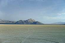
Sheephead Mountains
| Sheephead Mountains | |
|---|---|
| Highest point | |
| Elevation | 1,750 m (5,740 ft) |
| Geography | |
| Country | United States |
| State | Nevada |
| District | Pershing County |
| Range coordinates | 40°38′0.647″N 118°57′18.615″W / 40.63351306°N 118.95517083°WCoordinates: 40°38′0.647″N 118°57′18.615″W / 40.63351306°N 118.95517083°W |
| Topo map | USGS Sheep Spring |

The Sheephead Mountains are a mountain range in Pershing County, Nevada.[1]
References
- 1 2 "Sheephead Mountains". Geographic Names Information System. United States Geological Survey. Retrieved 2009-05-04.
This article is issued from
Wikipedia.
The text is licensed under Creative Commons - Attribution - Sharealike.
Additional terms may apply for the media files.