Kamma Mountains
| Kamma Mountains | |
|---|---|
| Highest point | |
| Elevation | 1,892 m (6,207 ft) |
| Geography | |
| Country | United States |
| State | Nevada |
| Region | Black Rock Desert |
| District |
Pershing County / Humboldt County |
| Range coordinates | 40°46′14.646″N 118°39′53.578″W / 40.77073500°N 118.66488278°WCoordinates: 40°46′14.646″N 118°39′53.578″W / 40.77073500°N 118.66488278°W |
| Topo map | USGS Sulphur |

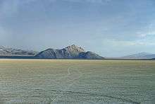
The Kamma Mountains are a mountain range in Pershing County and Humboldt County, Nevada.[1] The ghost town and railroad siding at Sulphur, Nevada is on the west side of the Kamma Mountains at the eastern edge of the Black Rock Desert playa.
The Kamma Mountains are the site of Nevada's Sulphur Mining District.[2] Allied Nevada Gold Corporation operates the Hycroft Gold Mine, a strip mine in the Kamma Mountains. Allied Nevada re-opened the mine in 2008 after acquiring it from Vista Gold Corporation.[3][4]
Jungo Road (State Route 49) connects east through the Kamma Mountains to Winnemucca and south to Gerlach via Sulphur.
References
- 1 2 "Kamma Mountains". Geographic Names Information System. United States Geological Survey. Retrieved 2009-05-04.
- ↑ "Sulphur Mining District". Geographic Names Information System. United States Geological Survey.
- ↑ "Technical Report – Vista Gold Corp: Hycroft Mine, Winnemucca, Nevada, USA" (PDF). Vista Gold Corporation. 2006-01-25. Archived from the original (PDF) on 2008-03-09. Retrieved 2008-04-26.
- ↑ Allied Nevada Gold Corporation (2009-05-15). "Hycroft Mine Technical Report" (PDF). Archived from the original (PDF) on 2010-09-17. Retrieved 2010-01-16.
External links
- Kamma Mountains at mountainzone.com
This article is issued from
Wikipedia.
The text is licensed under Creative Commons - Attribution - Sharealike.
Additional terms may apply for the media files.