East Butler, Pennsylvania
| East Butler, Pennsylvania | |
|---|---|
| Borough | |
| Borough of East Butler | |
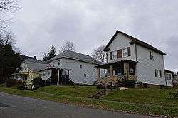 Houses on Broadway | |
 Location of East Butler in Butler County, Pennsylvania. | |
.svg.png) Location of Pennsylvania in the United States | |
| Coordinates: 40°52′40″N 79°50′38″W / 40.87778°N 79.84389°WCoordinates: 40°52′40″N 79°50′38″W / 40.87778°N 79.84389°W | |
| Country | United States |
| State | Pennsylvania |
| County | Butler County |
| Township | Summit Township |
| Settled | 1927 |
| Area[1] | |
| • Total | 1.04 sq mi (2.70 km2) |
| • Land | 1.04 sq mi (2.70 km2) |
| • Water | 0.00 sq mi (0.00 km2) |
| Population (2010) | |
| • Total | 732 |
| • Estimate (2016)[2] | 698 |
| • Density | 669.22/sq mi (258.46/km2) |
| Time zone | UTC-5 (EST) |
| • Summer (DST) | UTC-4 (EDT) |
| ZIP code | 16029 |
| Area code(s) | 724 |
| FIPS code | 42-20904 |
| School District | Butler Area School District |
East Butler is a borough in Butler County, Pennsylvania, United States. The population was 732 at the 2010 census.[3]
Geography
East Butler is located east of the center of Butler County at 40°52′40″N 79°50′38″W / 40.87778°N 79.84389°W (40.877703, -79.843921),[4] in the valley of Bonnie Brook, a tributary of Connoquenessing Creek. It is 3 miles (5 km) east of downtown Butler, the county seat.
According to the United States Census Bureau, the borough of East Butler has a total area of 1.0 square mile (2.7 km2), all of it land.[3]
Demographics
| Historical population | |||
|---|---|---|---|
| Census | Pop. | %± | |
| 1930 | 521 | — | |
| 1940 | 559 | 7.3% | |
| 1950 | 758 | 35.6% | |
| 1960 | 1,007 | 32.8% | |
| 1970 | 919 | −8.7% | |
| 1980 | 799 | −13.1% | |
| 1990 | 725 | −9.3% | |
| 2000 | 679 | −6.3% | |
| 2010 | 732 | 7.8% | |
| Est. 2016 | 698 | [2] | −4.6% |
| Sources:[5][6][7] | |||
As of the census[6] of 2000, there were 679 people, 295 households, and 184 families residing in the borough. The population density was 650.4 people per square mile (252.1/km²). There were 302 housing units at an average density of 289.3 per square mile (112.1/km²). The racial makeup of the borough was 99.71% White, 0.15% Asian, and 0.15% Pacific Islander. Hispanic or Latino of any race were 0.15% of the population.
There were 295 households, out of which 26.8% had children under the age of 18 living with them, 53.2% were married couples living together, 6.8% had a female householder with no husband present, and 37.6% were non-families. 33.2% of all households were made up of individuals, and 14.2% had someone living alone who was 65 years of age or older. The average household size was 2.30 and the average family size was 2.97.
In the borough the population was spread out, with 20.9% under the age of 18, 8.0% from 18 to 24, 29.2% from 25 to 44, 24.9% from 45 to 64, and 17.1% who were 65 years of age or older. The median age was 40 years. For every 100 females there were 98.0 males. For every 100 females age 18 and over, there were 92.5 males.
The median income for a household in the borough was $34,821, and the median income for a family was $41,375. Males had a median income of $32,917 versus $24,375 for females. The per capita income for the borough was $20,242. About 6.2% of families and 8.4% of the population were below the poverty line, including 10.6% of those under age 18 and 1.6% of those age 65 or over.
References
- ↑ "2016 U.S. Gazetteer Files". United States Census Bureau. Retrieved Aug 13, 2017.
- 1 2 "Population and Housing Unit Estimates". Retrieved June 9, 2017.
- 1 2 "Geographic Identifiers: 2010 Demographic Profile Data (G001): East Butler borough, Pennsylvania". U.S. Census Bureau, American Factfinder. Retrieved March 24, 2014.
- ↑ "US Gazetteer files: 2010, 2000, and 1990". United States Census Bureau. 2011-02-12. Retrieved 2011-04-23.
- ↑ "Census of Population and Housing". U.S. Census Bureau. Archived from the original on 12 May 2015. Retrieved 11 December 2013.
- 1 2 "American FactFinder". United States Census Bureau. Archived from the original on 2013-09-11. Retrieved 2008-01-31.
- ↑ "Incorporated Places and Minor Civil Divisions Datasets: Subcounty Resident Population Estimates: April 1, 2010 to July 1, 2012". Population Estimates. U.S. Census Bureau. Archived from the original on 17 June 2013. Retrieved 11 December 2013.
| Counties |  Map of the Pittsburgh Tri-State with green counties in the metropolitan area and yellow counties in the combined area. | |
|---|---|---|
| Major cities | ||
| Cities and towns 15k-50k (in 2010) | ||
| Airports | ||
| Topics | ||
| ||
Municipalities and communities of Butler County, Pennsylvania, United States | ||
|---|---|---|
| City | 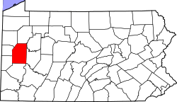 | |
| Boroughs | ||
| Townships | ||
| CDPs | ||
| Unincorporated communities | ||
| Footnotes | ‡This populated place also has portions in an adjacent county or counties | |