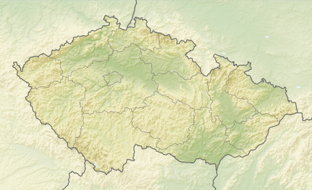
Dyje–Svratka Valley
| Dyje–Svratka Valley | |
|---|---|
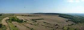 View from Výhon down to the Dyje–Svratka Valley | |
| Highest point | |
| Peak | Výhon |
| Elevation | 355 m n.m. |
| Dimensions | |
| Length | 83 km (52 mi) |
| Area | 1,452 km2 (561 sq mi) |
| Geography | |
 Dyje-Svratka Valley | |
| Country | Czech Republic |
| State | Moravia |
| Range coordinates | 49°00′N 16°18′E / 49°N 16.3°ECoordinates: 49°00′N 16°18′E / 49°N 16.3°E |
| Parent range | Carpathians |
| Geology | |
| Orogeny | Alpide belt, outer depression |
| Age of rock | Neogene |
| Type of rock | Gravel and Sand |
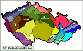
The Dyje–Svratka Valley (Czech: Dyjsko-svratecký úval, German: Thaya-Schwarza Talsenke, Slovak: Dyjsko-svratecký úval) is a geomorphological feature (specifically a special type of vale) in Moravia (The Czech Republic). The highest prominence over the Dyje–Svratka Valley is Děvín Peak at 549 metres (1,801 ft).
History
The Dyje–Svratka Valley has been a natural pass between the Vienna Basin (Carpathians) and the Vyškov Gate, the Upper Morava Valley, Moravian Gate and later, the North European Plain (Poland - Lower Silesia - Galicia) since ancient times. It served as an arm of several important trade routes from southern Europe to the Baltic Sea such as the Amber Road, as well as routes from Moravia to Upper Silesia and Lesser Poland.
The Emperor Ferdinand Northern Railway from Břeclav to Brno traverses the Dyje–Svratka Valley.
Access
Highways that traverse the Dyje-Svratka Valley include D1 from Prague to Brno, D2 from Brno to Břeclav and Bratislava, and D52 from Brno to Vienna).
Geography
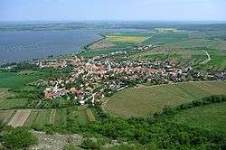
The floodplains of several rivers end in the Dyje-Svratka Valley, including Svratka, Jihlava, Svitava, Dyje, Jevišovka and Litava. Many towns are located within it, including the southern districts of Brno, Slavkov/Austerlitz, Židlochovice, Pohořelice, Hrušovany nad Jevišovkou and Mikulov.
The Lowlands are poorly forested, mostly by riparian forest (oaks, populus and willows), with higher areas forested by false akacia (Robinia pseudoacacia[1]). The Lowlands are intensively farmed, with significant numbers of orchards (peaches, walnuts, apricots and almonds), vineyards and small woods. Only a few small sections are still covered by natural vegetation.[2] The west valley contains numerous vineyards that are part of the wine making sub-regions of Mikulovská and Znojemská.
It is formed by the depression between the Carpathian Mountains in the east (Ždánice Forest, Kyjov Hills and Mikulov Hills) and the Bohemian massif in the west. Drainage runs into the River Morava, from there into the Danube basin and finally into the Black Sea.
It includes the low drainage divide Svratka-Dyje close to Mušov. Its soils mainly consist of chernozem and loess, local fluvisol and sand.
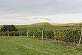
 Pavlov and Pavlov lake
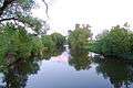 Svratka river south of Brno
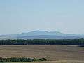 Look from Výhon, Akátová tower to the south
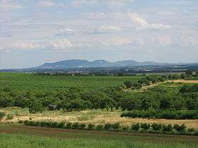 Moravian Dyje–Svratka Valley: view from Dolní Kounice to the southeast, Palava Hills on the horizon
 Vineyards below the Pálava Hills
 Svratka river in Rajhrad
See also
- Vyškov Gate
- Subcarpathia
- Outer Carpathian depressions
- South-Moravian Carpathians
- Upper Morava Valley
- Lower Morava Valley
References
- (1993) Geografický místopisný slovník, Academia, Praha. ISBN 80-200-0445-9
- (1997) Plašienka, D., Grecula, P., Putiš, M., Kováč, M. a Hovorka, D.,: Evolution and structure of the Western Carpathians: an overview. Mineralia Slovaca - Monograph, Košice, s. 1 – 24. ISBN 978-80-967018-7-2
- (2010) Filip, A., Krejčí, J. (Photo), : Brno - City Guide: Brno, K-Public. ISBN 978-80-87028-08-7
| Wikimedia Commons has media related to Dyjsko-svratecký úval. |