Thaya
| Thaya (Dyje) | |
|---|---|
 Thaya in Břeclav | |
| Country | Czech Republic, Austria |
| Physical characteristics | |
| Main source |
near Panenská Rozsíčka 410 m (1,350 ft) |
| River mouth |
Morava River 148 m (486 ft) 48°37′01″N 16°56′25″E / 48.6170°N 16.9402°ECoordinates: 48°37′01″N 16°56′25″E / 48.6170°N 16.9402°E |
| Length | 223.9 km (139.1 mi) [1] |
| Discharge |
|
| Basin features | |
| Progression | Morava→ Danube→ Black Sea |
| Basin size | 13,419 km2 (5,181 sq mi) |
The Thaya (Czech: Dyje [ˈdɪjɛ]) is a river in Central Europe, the longest tributary to the Morava River. It is 224 km (139 mi) (322 km (200 mi) with its longest source river German Thaya) long[1] and meanders from west to east in the border area between Lower Austria (Austria) and South Moravia (Czech Republic), though the frontier does not exactly follow the river's course in most parts. Its source is in two smaller rivers, namely the German Thaya (Deutsche Thaya) and the Moravian Thaya (Czech: Moravská Dyje, German: Mährische Thaya), flowing together at Raabs.
Its name means "the inert". There is also a small village which bears the name Dyje, located near Znojmo.
Geography
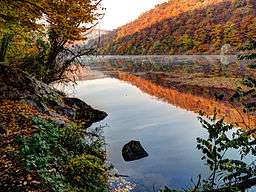
In its upper reaches, the Thaya flows through deep gorges (Podyjí), along which it passes many castles and chateaus. In Moravia, it has been dammed in several locations.
Thaya gathers waters from the western half of Moravia and the adjacent part of Lower Austria. Its biggest tributaries are Svratka and Jihlava, flowing together into the middle one of the Nové Mlýny reservoirs.
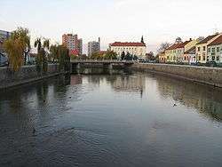
Important cities and towns along the Thaya:
Dams
All the dams are situated in Czech Republic. They are used for irrigation, hydroelectricity and flood protection.
| Dam Name | Dimension Level Altitude | Qav | Q100 | Qmax. | Power Station | Type | Qpp |
|---|---|---|---|---|---|---|---|
| Vranov | 348,45 | 9.74m3s−1 | 260m3s−1 | 364m3s−1 | 18.9 MW | Conventional | 45m3s−1 |
| Znojmo | 225,6 | 10.25m3s−1 | 280m3s−1 | 379m3s−1 | 1.4 WM | run-of-the-river | 12m3s−1 |
| Nove Mlyny I (upper reservoir) | 171,4 | 13.3m3s−1 | 290m3s−1 | see lower reservoir | N/A | N/A | N/A |
| Nove Mlyny II (middle reservoir) | 170,35 | 40.9m3s−1 | see lower reservoir | see lower reservoir | N/A | N/A | N/A |
| Nove Mlyny III (lower reservoir) | 170,35 | 40.9m3s−1 | 820m3s−1 | 657m3s−1 | 2.4 MW | run-of-the-river | 48m3s−1 |
| Wikimedia Commons has media related to Thaya. |
References
- 1 2 Niederösterreich Atlas (Lower Austria)