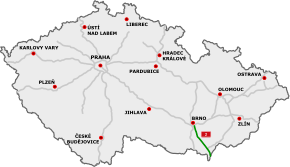
D2 motorway (Czech Republic)
| |
|---|---|
| Dálnice D2 | |
 | |
| Route information | |
|
Part of | |
| Length | 61 km (38 mi) |
| Major junctions | |
| From |
|
| To |
|
| Location | |
| Regions: | South Moravian |
| Major cities | Brno |
| Highway system | |

D2 motorway (Czech: Dálnice D2) is a highway in the Czech Republic. It runs from the City of Brno to the border with Slovakia at the Morava river near Lanžhot, from where the Slovak diaľnica D2 leads to Bratislava.
Construction on the D2 highway began in 1974; the first 11 kilometers (6.8 mi) opened in 1978. The last part of the motorway opened in 1980, when it was 141 km (88 mi) long. After the 1993 dissolution of Czechoslovakia, 61 km (38 mi) remain in Czech Republic, 80 km (50 mi) in Slovakia.
Features
| Point | Coordinates (links to map & photo sources) |
|---|---|
| City of Brno | 49°09′45″N 16°37′56″E / 49.162402°N 16.632129°E |
| Village of Starovičky | 48°54′34″N 16°46′50″E / 48.909380°N 16.780531°E |
| border with Slovakia at the Morava river | 48°41′10″N 16°59′14″E / 48.686175°N 16.987238°E |
Images
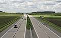 D2 motorway near Blučina
See also
External links
![]()
This article is issued from
Wikipedia.
The text is licensed under Creative Commons - Attribution - Sharealike.
Additional terms may apply for the media files.