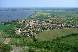
Pavlov (Břeclav District)
| Pavlov | |||
|---|---|---|---|
| Municipality | |||
 | |||
| |||
 Pavlov | |||
| Coordinates: 48°52′28″N 16°40′16″E / 48.87444°N 16.67111°ECoordinates: 48°52′28″N 16°40′16″E / 48.87444°N 16.67111°E | |||
| Country |
| ||
| Region | South Moravian | ||
| Moravia, District | Břeclav | ||
| Area | |||
| • Total | 13.03 km2 (5.03 sq mi) | ||
| Elevation | 245 m (804 ft) | ||
| Population (1.1.2012) | |||
| • Total | 553 | ||
| • Density | 42/km2 (110/sq mi) | ||
| Postal code | 692 01 | ||
| Website | http://www.obec-pavlov.cz | ||
Pavlov (German Pollau) is a village and municipality (obec) in Břeclav District, Moravia, Czech Republic. Under the Děvín Mountain 549 metres (1,801 ft).
The municipality covers an area of 13.03 square kilometres (5.03 sq mi), and has a population of 537 (as at 2005).
Pavlov lies approximately 21 kilometres (13 mi) north-west of Břeclav, 37 km (23 mi) south of Brno, and 212 km (132 mi) south-east of Prague.
See also
References
| Wikimedia Commons has media related to Pavlov (Břeclav District). |
This article is issued from
Wikipedia.
The text is licensed under Creative Commons - Attribution - Sharealike.
Additional terms may apply for the media files.