Diddillibah, Queensland
| Diddillibah Maroochydore, Queensland | |||||||||||||||
|---|---|---|---|---|---|---|---|---|---|---|---|---|---|---|---|
 Diddillibah | |||||||||||||||
| Coordinates | 26°38′54″S 153°01′34″E / 26.6483°S 153.0261°ECoordinates: 26°38′54″S 153°01′34″E / 26.6483°S 153.0261°E | ||||||||||||||
| Population | 1,403 (2016 census)[1] | ||||||||||||||
| • Density | 113.1/km2 (293.0/sq mi) | ||||||||||||||
| Postcode(s) | 4559 | ||||||||||||||
| Area | 12.4 km2 (4.8 sq mi) | ||||||||||||||
| Location |
| ||||||||||||||
| LGA(s) | Sunshine Coast Region | ||||||||||||||
| State electorate(s) | Ninderry | ||||||||||||||
| Federal Division(s) | Fairfax | ||||||||||||||
| |||||||||||||||
Diddillibah is a suburb of Maroochydore on the Sunshine Coast Region in Queensland, Australia.[2] In the 2016 census, Diddillibah had a population of 1,403 people.[1]
History
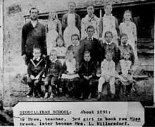
Students at Diddillibah Provisional School, circa 1891
Its name comes from a local Aboriginal word dhilla, which means "coarse grass" or "carpet snake" and ba, which means "place". Also known as the "valley of the snakes".[2][3][4]
Diddillibah Provisional School opened on 14 September 1885, becoming Diddillibah State School on 1 January 1909. It closed on 14 May 1962.[5]
References
- 1 2 Australian Bureau of Statistics (27 June 2017). "Diddillibah (SSC)". 2016 Census QuickStats. Retrieved 9 June 2018.

- 1 2 "Diddillibah - locality in the Sunshine Coast Region (entry 48607)". Queensland Place Names. Queensland Government. Retrieved 9 June 2018.
- ↑ South East Queensland—Place Names 16 December 2006
- ↑ Maroochy Council—Place Name Origins Archived 10 December 2006 at the Wayback Machine. 16 December 2006
- ↑ Queensland Family History Society (2010), Queensland schools past and present (Version 1.01 ed.), Queensland Family History Society, ISBN 978-1-921171-26-0
External links
![]()
- "Diddillibah". Queensland Places. Centre for the Government of Queensland, University of Queensland.
This article is issued from
Wikipedia.
The text is licensed under Creative Commons - Attribution - Sharealike.
Additional terms may apply for the media files.