Thargomindah
| Thargomindah Queensland | |||||||||||||||
|---|---|---|---|---|---|---|---|---|---|---|---|---|---|---|---|
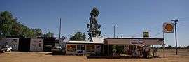 Outback roadhouse of Thargomindah | |||||||||||||||
 Thargomindah | |||||||||||||||
| Coordinates | 27°59′32″S 143°49′11″E / 27.9922°S 143.8197°ECoordinates: 27°59′32″S 143°49′11″E / 27.9922°S 143.8197°E | ||||||||||||||
| Population | 270 (2016 census)[1] | ||||||||||||||
| • Density | 5.53/km2 (14.33/sq mi) | ||||||||||||||
| Postcode(s) | 4482 | ||||||||||||||
| Area | 48.8 km2 (18.8 sq mi) | ||||||||||||||
| Location |
| ||||||||||||||
| LGA(s) | Shire of Bulloo | ||||||||||||||
| State electorate(s) | Warrego | ||||||||||||||
| Federal Division(s) | Maranoa | ||||||||||||||
| |||||||||||||||
| |||||||||||||||
Thargomindah /ˈθɑːrɡoʊmɪndə/ is a town and a locality in the Shire of Bulloo, Queensland, Australia.[2][3] At the 2016 census, Thargomindah had a population of 270.[1] It was founded on Wongkumara and Kalali territory.
Geography
Thargominah is in South West Queensland on the Adventure Way, approximately 1,100 kilometres (680 mi) west of the state capital, Brisbane, and 200 kilometres (120 mi) west of the town of Cunnamulla. Thargomindah is the administrative centre for the Shire of Bulloo and lies on the Bulloo River.
Facilities
An information centre is located at 37 Dowling Street, Thargomindah. The building is a renovation of a children's hostel which was built in early 1960, it then became a block of flats and ended up being an empty run-down building until converted to a very modern facility containing the Visitor Information Centre, Library and Coffee Shop. The hostel was used for children who lived in remote properties where they would board at the hostel during the week, returning home on the weekends to their families.
The Information Centre contains brochures, pamphlets and maps on the South West Queensland corner and surrounding areas. It is the first place where people stop when they visit Thargomindah to get the latest road conditions, directions, places to stay, things to see and do and the latest information on events.
Bulloo Shire Council operates Thargomindah Library at Shire Office, Dowling Street, Thargomindah.[4]
Thargomindah has two fuel stations; Thargo Motors which is open Mon to Fri and Sat mornings and Thargo Roadhouse which has 24 hour fuel using an EFTPOS facility.
Accommodation consists of the Oasis Motel, Bulloo River Hotel Motel, Explorers Caravan Park and Napunyah Caravan Park.
Dining out options are the Oasis Motel, Bulloo River Hotel Motel, Coffee on Dowling and Thargo Roadhouse.
Heritage listings
Thargomindah has a number of nearby heritage-listed sites, including:
- Bulloo River, Bulloo Downs: Dr Ludwig Becker's Grave[5]
- Nappa Merrie Station, Durham: Burke and Wills Dig Tree[6]
- Wilson Street, Noccundra: Noccundra Hotel[7]
Water
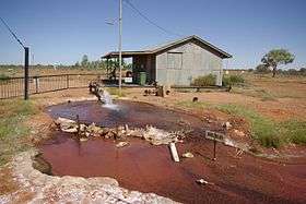
Thargomindah has a pressurised hot spring from a bore into the Great Artesian Basin and has produced hydroelectric power from the basin in the past. After 2 years of drilling, a good supply of water was found in 1893. The temperature was 86 °C (187 °F). In 1924, it was recorded that the bore had a daily output of 2,500 cubic metres (88,000 cu ft) and today of 1,300 cubic metres (46,000 cu ft) at 84 °C (183 °F). There is a plentiful water supply for the population and the arid area available for irrigation in front and backyards and public warm showers are provided.
History

The town was first settled in the 1860s at a crossing of the Bulloo River.[8] A post office was established in 1870 and a telegraph line connected the town to Cunnamulla in 1881. The 1890s saw the town prosper as the service and administrative centre of a pastoral district.[8]
Thargomindah was one of the first towns in Australia to produce hydroelectric power from 1898 until 1951, which then was taken over by diesel generators until 1988. The town was later connected to the national power grid via Cunnamulla. The old bore was a source of energy when electric street lights were lit and coupled to a turbine driven by the bore's natural water pressure. The generator was taken from a unit powered by a steam engine and purchased by the Bulloo Divisional Board becoming the first municipality owned power plant. The power station is still operating with a daily opening to the public.
At the 2006 census, Thargomindah had a population of 203.[9]
Transport
Thargomindah Airport is located near the township. A railway extension to the town was planned for many years, however it never eventuated. The railway did reach Cunnamulla in 1898 and Quilpie in 1917.[8]
Climate
Thargomindah has a hot semi-arid climate.
| Climate data for Thargomindah | |||||||||||||
|---|---|---|---|---|---|---|---|---|---|---|---|---|---|
| Month | Jan | Feb | Mar | Apr | May | Jun | Jul | Aug | Sep | Oct | Nov | Dec | Year |
| Record high °C (°F) | 48.8 (119.8) |
46.0 (114.8) |
43.8 (110.8) |
38.9 (102) |
32.2 (90) |
30.4 (86.7) |
28.5 (83.3) |
36.3 (97.3) |
39.2 (102.6) |
41.2 (106.2) |
45.4 (113.7) |
45.0 (113) |
48.8 (119.8) |
| Average high °C (°F) | 38.5 (101.3) |
36.0 (96.8) |
33.5 (92.3) |
29.5 (85.1) |
23.8 (74.8) |
20.0 (68) |
20.1 (68.2) |
22.9 (73.2) |
27.8 (82) |
31.1 (88) |
33.8 (92.8) |
36.4 (97.5) |
29.5 (85.1) |
| Average low °C (°F) | 25.5 (77.9) |
24.0 (75.2) |
21.2 (70.2) |
16.6 (61.9) |
10.6 (51.1) |
7.5 (45.5) |
6.7 (44.1) |
8.3 (46.9) |
12.8 (55) |
16.6 (61.9) |
20.6 (69.1) |
23.0 (73.4) |
16.1 (61) |
| Record low °C (°F) | 17.2 (63) |
12.3 (54.1) |
9.4 (48.9) |
6.5 (43.7) |
1.0 (33.8) |
−0.8 (30.6) |
−0.9 (30.4) |
0.1 (32.2) |
4.7 (40.5) |
6.2 (43.2) |
9.7 (49.5) |
13.7 (56.7) |
−0.9 (30.4) |
| Average precipitation mm (inches) | 39.1 (1.539) |
47.9 (1.886) |
45.5 (1.791) |
17.5 (0.689) |
14.4 (0.567) |
16.7 (0.657) |
13.6 (0.535) |
8.0 (0.315) |
9.8 (0.386) |
14.1 (0.555) |
40.7 (1.602) |
30.3 (1.193) |
300.4 (11.827) |
| Average precipitation days | 3.6 | 4.5 | 4.4 | 1.4 | 2.8 | 3.9 | 3.5 | 2.0 | 2.6 | 3.4 | 5.5 | 4.4 | 42.0 |
| Source: [10] | |||||||||||||
References
- 1 2 Australian Bureau of Statistics (27 June 2017). "Thargomindah (State Suburb)". 2016 Census QuickStats. Retrieved 26 October 2017.

- ↑ "Thargomindah - town in Shire of Bulloo (entry 33819)". Queensland Place Names. Queensland Government. Retrieved 4 August 2017.
- ↑ "Thargomindah - locality in Shire of Bulloo (entry 42949)". Queensland Place Names. Queensland Government. Retrieved 4 August 2017.
- ↑ "Thargomindah Library". Public Libraries Connect. State Library of Queensland. Retrieved 22 January 2018.
- ↑ "Dr Ludwig Becker's Grave (entry 601359)". Queensland Heritage Register. Queensland Heritage Council. Retrieved 7 July 2013.
- ↑ "Burke and Wills Dig Tree (entry 601073)". Queensland Heritage Register. Queensland Heritage Council. Retrieved 7 July 2013.
- ↑ "Noccundra Hotel (entry 600361)". Queensland Heritage Register. Queensland Heritage Council. Retrieved 7 July 2013.
- 1 2 3 Environmental Protection Agency (Queensland) (2002). Heritage Trails of the Queensland Outback. State of Queensland. pp. 114–115. ISBN 0-7345-1040-3.
- ↑ Australian Bureau of Statistics (25 October 2007). "Thargomindah (L) (Urban Centre/Locality)". 2006 Census QuickStats. Retrieved 25 July 2009.
- ↑ "Climate statistics for Thargomindah". Bureau of Meteorology. Retrieved 13 April 2013.
External links
| Wikimedia Commons has media related to Thargomindah, Queensland. |

- Bulloo Shire
- Thargomindah on Action Graphics
- Thargomindah on WalkAbout
- Hydro Power Plant